Maps of Bjugn

1522-1 Botngård
1 : 50000 Statens kartverk
1522-1 Jössund
1 : 50000 Norges Geografiske Oppmåling
1522-1 Bjugn
1 : 50000 Statens kartverk
1522-1 Bjugn
1 : 50000 Norges Geografiske Oppmåling
1522-1 Bjugn
1 : 50000 Statens kartverk
49B 9; 49B 10; 49D 1; 49D 2
1 : 50000 Wilhelm Sørensen
49B 2; 49B 6
1 : 50000 Hans Gjestvang
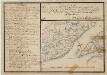
Museumskart 126: Kaart over endeel af den Norske Søe-Kyst udi Trondhiems Stift
1 : 75000 Carl Frederik Grove
49B Stjørna
1 : 100000 C. Pedersen | Johan Ferdinand Nordmann
49B Stjørna
1 : 100000
49B Stjørna
1 : 100000
49B Skjørn
1 : 100000 Johan Ferdinand Nordmann
49B Stjørna
1 : 100000
Geologiske kart 2 Den geologiske Undersøgelse, Skjørn
1 : 100000 M. Bugge | Theodor Kjerulf | Normann | K. M. Hauan Norges geologiske undersøkelse
Museumskart 125: Kaart over endeel af den Norske Søe-Kyst udi Trondhiems Stift
1 : 75000 Carl Frederik Grove
49B 11; 49D 3
1 : 50000 Hans Gjestvang | Fredrik Wille
49A 4; 49A 8; 49B 1; 49B 5
1 : 50000 Oluf Holm
49D 5
1 : 50000 Thomas Hans Knoff
1522-2 Rissa
1 : 50000 Statens kartverk
1523-2 Stokksund
1 : 50000 Norges Geografiske Oppmåling
1522-2 Rissa
1 : 50000 Statens kartverk
1522-2 Rissa
1 : 50000 Statens kartverk
1522-2 Rissa
1 : 50000 Norges Geografiske Oppmåling
1522-2 Stjörna
1 : 50000 Norges Geografiske Oppmåling
Kartblad 96: Situations-Cart over det Redsenske Compagnie
Johan Christian Throne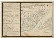
Kartblad 77-2: Situations Chart over det Frostensche Compagnie; versjon 2
Ebbe Carsten Hendrich Coldevin
Kartblad 98: Situations-Cart over det Biørnørsche Compagnie District
Grønn
Trigonometrisk grunnlag, Squelet-Cart 65-16

Trigonometrisk grunnlag, Squelet-Cart 37: Trigonometrisk Kart for 1828
1 : 400000 Vibe