Maps of Lesja

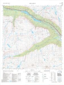
1419-3 Lesjaskog
1 : 50000 Statens kartverk
1419-3 Lesjaskog
1 : 50000 Statens kartverk
1419-3 Lesjaskog
1 : 50000 Statens kartverk
1419-3 Lesjaskog
1 : 50000 Norges Geografiske Oppmåling
36B 6; 36B 7; 36B 10; 36D 1; 36D 2; 36C 4
1 : 100000
Kroki i 100000 over terrenget Snenuten Vassdalseggen
1 : 100000 Finn Qvale
E29-8, E29-9
1 : 50000 Gunvald Hagene | Gustav Adolf Tajet
Spesielle kart 103-2: Flötningskart over Glommens Vassdrag
1 : 1000 Einar Sigurd Ween
36D 3; 36D 4; 36D 7; 36D 8; 36D 11; 36D 12; 36B 8; 36B 11; 36B 12; 37A 5; 37A 9; 37C 1; 37C 5; 37C 9
1 : 100000 Schilling
36B 8; 36B 11; 36B 12; 36D 3; 36D 4; 36D 7; 36D 8; 36D 11; 36D 12; 37A 5; 37A 9; 37C 1; 37C 5; 37C 9
1 : 100000 Schilling
36D 5; 36D 6; 36D 9; 36D 10; 36D 11; 36C 8; 41B 2; 41B 3
1 : 100000
Kart i 100000 over terrenget om Aura`s nedslagsfelt
1 : 100000 Finn Qvale | Marius Widerøe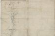
Kartblad 53 nord: Militair Vej-Cart over det Læssøeske Compagnie District; nordre del
P. T. Coucheron
Kart over trakten om Aursjøen - Eikisdalen - Litledalen
1 : 100000
1419-4 Aursjöen
1 : 50000 Statens kartverk
1419-4 Aursjöen
1 : 50000 Norges Geografiske Oppmåling
D29-12; E29-7
1 : 50000 Gunvald Hagene
[Romsdals Amt]
1 : 200000 Norsko Norges geografiske Opmaling
Norge 55-9: Accurat landcaart over Norges Rige anden Part
1 : 300000 G. Bordin
Trigonometrisk grunnlag, Squelet-Cart 36: Skelet-kart over de trigonometrisk bestemte Punkter Sommeren 1827
Th. Broch
Geologisk kart over det Söndenfjeldske Norge
1 : 400000 Nordwest-Blatt Kjerulf, Theodor ; Dahll, Tellef Carl Schwenzens
Bl. XI Molde
1 : 300000
Spesielle kart: Tyngdeanomalikart, Ã...lesund
1 : 250000 NGO
Midt-Jotunheimen
1 : 50000 Norsko Norges geografiske Opmaling
XI
1 : 400000 N. Franck
Spesielle kart 122-6: Postkart over Norge
1 : 400000 Toralf à ̃yen
XI
1 : 400000 N. Franck
Statistikk 38-6: Bosettingskart over Møre og Romsdal, Sogn og Fjordane og Oppland. Blad 6
1 : 400000 Statistisk Sentralbyrå
Spesielle kart nr 44: Sell - Opdal - Støren og Opdal - Sundal - Molde
1 : 400000