Maps of Lesja

1419-2 Dombås
1 : 50000 Norges Geografiske Oppmåling
Fra Ruste til Hardbakken og fra Holom via Dombås over Hundyrju
1 : 20000 J. H. Reichborn
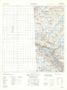
1419-2 Dombås
1 : 50000 Statens kartverk
1419-2 Dombås
1 : 50000 Statens kartverk
1419-2 Dombås
1 : 50000 Norges Geografiske Oppmåling
1419-2 Dombås
1 : 50000 Statens kartverk
37C 1; 37C 2; 37C 5; 37C 6
1 : 50000 Niels Sire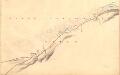
Fra Fokkstugu til Vålåsjøen
1 : 20000 J. H. Reichborn
37C Dovrefjell
1 : 100000
37C Dovrefjell
1 : 100000
37C Dovrefjell
1 : 100000
37C Dovrefjell
1 : 100000
36D 3; 36D 4; 36D 7; 36D 8; 36D 11; 36D 12; 36B 8; 36B 11; 36B 12; 37A 5; 37A 9; 37C 1; 37C 5; 37C 9
1 : 100000 Schilling
36B 8; 36B 11; 36B 12; 36D 3; 36D 4; 36D 7; 36D 8; 36D 11; 36D 12; 37A 5; 37A 9; 37C 1; 37C 5; 37C 9
1 : 100000 Schilling
37A 5; 37A 9; 37A 10
1 : 50000 Adler Gleditsch
37A 10
1 : 50000 Berthold Dahl
37A Dovre
1 : 100000
37A Dovre
1 : 100000
37A Dovre
1 : 100000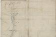
Kartblad 53 nord: Militair Vej-Cart over det Læssøeske Compagnie District; nordre del
P. T. Coucheron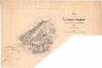
Kart over Fjeldstuen Fokstuen
1 : 25000 Haffner
37C 5; 37C 9
1 : 50000
1419-1 Storskrymten
1 : 50000 Statens kartverk
1419-1 Storskrymten
1 : 50000 Statens kartverk
Kartblad nr 10: Kaart over Postveien fra Korsødegaarden til Trondhjem igjennom Gulbrandsdalen over Dovrefjeld
1 : 20000 J. H. Reichborn
37C 6; 37C 10; 37C 11
1 : 50000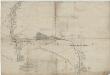
Kartblad 53 sør: Militair Vej-Cart over det Læssøeske Compagnie District; søndre del
P. T. Coucheron
Spesielle kart 103-3: Flötningskart over Glommens vassdrag
1 : 1000 Einar Sigurd Ween
Spesielle kart 103-13: Flötningskart over Glommens vassdrag
1 : 1000 Einar Sigurd Ween