Maps of Eidfjord

1415-4 Eidfjord
1 : 50000 Norges Geografiske Oppmåling
1415-4 Eidfjord
1 : 50000 Norges Geografiske Oppmåling
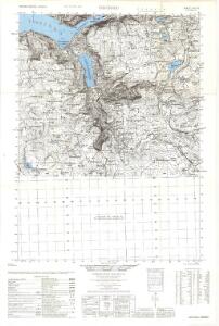
1415-4 Eidfjord
1 : 50000 Statens kartverk
1415-4 Eidfjord
1 : 50000 Statens kartverk
1415-4 Eidfjord
1 : 50000 Statens kartverk
Geologisk kart 111d: Hardangervidda - Blockbild
P. U. Thomsen | K. Schipull Hamburger Geographische Studien
C33-6
1 : 50000 Carl Gustav Fleischer
17D 6; 17D 7; 17D 10; 17D 11
1 : 100000 Carl Christophersen
Portefølje nr 28
1 : 100000 F. Sejersted | E. Lund
Geologisk kart 111a: Hardangervidda - Höhenschichten
1 : 200000 K. Schipull | P. U. Thomsen Hamburger Geographische Studien
C33 aust Ulvik
1 : 100000
C33 aust Ulvik
1 : 100000
D33-1; D33-2
1 : 50000 Gunvald Hagene | Kaare Kvisgaard
C33 aust Ulvik
1 : 100000
C33 aust Ulvik
1 : 100000
17D 8; 17D 12
1 : 100000 Lowzow
1415-3 Hårteigen
1 : 50000 Statens kartverk
C33-4; C33-5; C34-10; C34-11
1 : 100000 Johannes Oliver Smith
Kroki over en del av Haringvidda
1 : 100000 Finn Qvale
Museumskart 217-42: Specialkart over Hardangerfjorden. Østre del.
1 : 100000 M. T. Kingo | R. M. Petersen | H. N. Bergh Den Geografiske Opmaaling
Geologisk kart 111b: Hardangervidda - Flacheliefs
1 : 200000 P. U. Thomsen | K. Schipull Hamburger Geographische Studien
C34 nø/4
1 : 100000 Hjalmar Skaar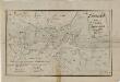
Kartblad 136: Situations-Cart over det Nordre Hardangerske Compagnie District
Lauritz Brix Grøn
Statistikk 40- Oversiktskart over Hardangeviddas beiteforhold

Hardangervidda
1 : 200000
Hardangervidda
1 : 200000
Hardangervidda

D34-1; D34-2; D34-7; D34-8
1 : 100000 Thorolv Ingar Ween
Museumskart 82: Hardangerfjorden
1 : 100000