Maps of Ullensvang herad

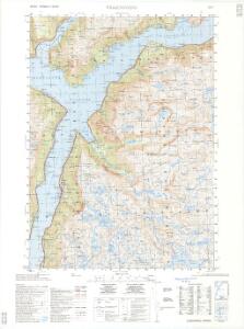
1315-1 Ullensvang
1 : 50000 Norges Geografiske Oppmåling
1315-1 Kinsarvik
1 : 50000 Statens kartverk
1315-1 Ullensvang
1 : 50000 Statens kartverk
1315-1 Ullensvang
1 : 50000 Statens kartverk
1315-1 Ullensvang
1 : 50000 Norges Geografiske Oppmåling
17D 5; 17D 9
1 : 50000 Christoffer Fredrik von Lowzow
C33-3; C33-4
1 : 50000 Oscar Thue
17D 9
1 : 50000 Christoffer Fredrik von Lowzow
C34-9; C34-10
1 : 50000 Thorolv Ingar Ween | Gustav Adolf Tajet
C33-4; C33-5; C34-10; C34-11
1 : 100000 Johannes Oliver Smith
Kartblad 137- Weie-Cort over det Søndre Hardangerske Compagnie District; a
Niels Henrich Bredal
C34-8; C34-9
1 : 50000 Axel P. Printz | Toralf Øyen
C33 aust Ulvik
1 : 100000
C33 aust Ulvik
1 : 100000
C33 vest Voss
1 : 100000
C33 vest Voss
1 : 100000
C33 aust Ulvik
1 : 100000
C33 aust Ulvik
1 : 100000
17C 7; 17C 8; 17C 11; 17C 12
1 : 50000 E. Lund
C33-3; C33-4; C33-5; C33-6; C33-6; C33-9; C33-10; C33-11; C33-12
1 : 50000 Oscar Thue
Kartblad 134-5: Cart over Wossiske Compagnie District; blad 5
Christopher Stenersen Collin
17C 3; 17C 4
1 : 50000 Carl Christophersen
C33-2; C33-3; C34-8; C34-9
1 : 50000 Thorolf Ingar Ween
C33-9; C33-10
1 : 50000 Gunvald Hagene
23B 1
1 : 50000 H. Lassen
Museumskart 217-42: Specialkart over Hardangerfjorden. Østre del.
1 : 100000 M. T. Kingo | R. M. Petersen | H. N. Bergh Den Geografiske Opmaaling
C34 nø/4
1 : 100000 Hjalmar Skaar
Museumskart 82: Hardangerfjorden
1 : 100000
Kartblad 136: Situations-Cart over det Nordre Hardangerske Compagnie District
Lauritz Brix Grøn