Maps of Odda

1314-1 Röldal
1 : 50000 Norges Geografiske Oppmåling
1314-1 Røldal
1 : 50000 Statens kartverk
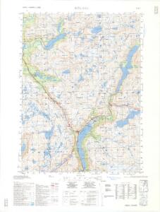
1314-1 Røldal
1 : 50000 Statens kartverk
1314-1 Røldal
1 : 50000 Statens kartverk
Kroki i 100000 over terrænget om Reinsaas
1 : 100000 H. K. Hertzberg
C35-9
1 : 50000 Alf Hattestad | N. Houge
12D 5; 12D 6; 12D 9; 12D 10
1 : 50000 Hedvard Carl Scharffenberg
C35-8; C35-9
1 : 50000 N. Houge
12C 8; 12C 12
1 : 50000 Hedvard Carl Scharffenberg
C35-4; C35-5; C35-6; C35-10; C35-11; C35-12
1 : 50000 Peter Vold
C35-4; C35-5; C35-6; C35-10; C35-11; C35-12
1 : 50000 Peter Vold
C35-2; C35-3
1 : 50000 Hjalmar Skaar
12C 4; 12C 8; 12C 12; 12D 1; 12D 2; 12D 3; 12D 5; 12D 6; 12D 9; 12D 10
1 : 100000 W. Næser
Kroki i 100000 over terrænet omkring Valdalen
1 : 100000 J. Rieck
Kroki over terrænet mellem Breifonn og Blyvardenuten
1 : 100000 Usmund Seim | Olaf Knutsen Garteig | Finn Qvale
Sammensetning av deler av følgende kart utgitt av Norges geografiske oppmåling
1 : 100000
Kroki i 100000 over terrænet mellem Breifonn og Blyvardenuten
1 : 100000 Finn Qvale | Usmund Seim | Olaf Knutsen Garteig
Kroki i 100000 over terrenget Snenuten Vassdalseggen
1 : 100000 Finn Qvale
Portefølje nr 19
1 : 100000 E. Lund
Kroki i 100000 over terrænet øst Sørfjordseggen med Tysso`s nedslagsfelt m. m.
1 : 100000 Finn Qvale
Portefølje nr 20
1 : 100000 F. Staib
17B 1; 17B 2; 17B 5; 17B 6; 17B 9; 17B 10; 17B 11; 17D 1; 17D 2; 17D 3
1 : 100000 H. Schauffenberg
17A 6; 17A 7; 17A 10; 17A 11
1 : 100000 Fougner
17A 2; 17A 3; 17A 4; 17A 8; 17A 12
1 : 100000 Fr. Sejersted
17A 2; 17A 3; 17A 4; 17A 8; 17A 12 (geometrisk hovednet)
1 : 100000 Fr. Sejersted
C35 vest Fjæra
1 : 50000
C34-2; C34-3; C34-4
1 : 50000 Axel P. Printz | Hjalmar Skaar
1315-2 Ringedalsvatnet
1 : 50000 Norges Geografiske Oppmåling
C34-2; C34-3; C34-4
1 : 50000 Hjalmar Skaar | Axel P. Printz