Maps of Stordal

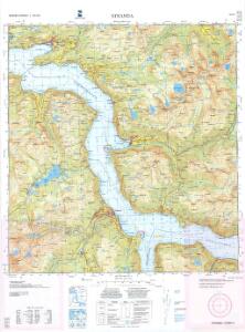
1219-1 Stranda
1 : 50000 Statens kartverk
1219-1 Stranda
1 : 50000 Norges Geografiske Oppmåling
1219-1 Stranda
1 : 50000 Statens kartverk
35D 11; 35D 12; 40B 3
1 : 50000 Aksel Magnus
40B 4; 40B 7; 40B 8
1 : 50000 Solem
40B 8 del
1 : 50000 Solem
Spesielle kart 113-1: Oversigtskart over de forskjellige Grænsealternativer mellem Trondhjems Stift og Hamar og Bergens Stifter
1 : 100000 J. Sejersted
Museumskart 99: Speciel Kaart over en Deel af den Norske Kyst indbefattende den Nordre Deel av Søndmøers Fogderie
1 : 75000 Carl Frederik Grove
Museumskart 98: Speciel Kaart over en Deel af den Norske Kyst. Storfjord til Haram
1 : 75000 Carl Frederik Grove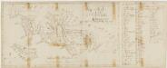
Kartblad 114: Wey-Cart over det Wæsneske Compagnie District

1220-2 Vestnes
1 : 50000 Norges Geografiske Oppmåling
Ålesund med omegn
1 : 50000 Ragnvald Hansen Alb. Gjørtz
35D 9; 35D 10; 40B 1; 40B 2
1 : 50000 Aksel Magnus
36C 9; 36C 10; 41A 1; 41A 2
1 : 50000 Erik Andreas Colban
K63 Molde
1 : 300000 Oberkommando des Heeres/Generalstab des Heeres
Trigonometrisk grunnlag, vedlegg 68-12
1 : 250000
Museumskart 217-68: Kart over Havbankerne Langs den Norske Kyst fra Stadt til Smølen
1 : 200000 M. Lyng Den Geografiske Opmaaling
Spesielle kart: Tyngdeanomalikart, Ã...lesund
1 : 250000 NGO
Kartblad 107: Situations Cart over det 2det Trondhiemske Regiments District
J. C. R.
Spesielle kart 122-6: Postkart over Norge
1 : 400000 Toralf à ̃yen
XI
1 : 400000 N. Franck
X
1 : 400000 N. Franck
Statistikk 38-6: Bosettingskart over Møre og Romsdal, Sogn og Fjordane og Oppland. Blad 6
1 : 400000 Statistisk Sentralbyrå
Norge 32e: Cituations Carte over en vis Bestreckning nemblig fra Trundhiem og til Opdalen
1 : 300000
DIOECESIS | TRVNDHEMIENSIS | PARS AVSTRALIS.
[Amsterdam : Joan Blaeu]
Norge 32a: Cituations Carte over en vis Bestreckning nemblig fra Trundhiem og til Opdalen
1 : 300000 G. M. D.
Kartblad 123-2: Carte over det Første Bergenhuusiske Regiments District; versjon 2

Spesielle kart nr 44: Sell - Opdal - Støren og Opdal - Sundal - Molde
1 : 400000
Dioecesis Trundhemiensis Pars Australis. [Karte], in: Novus atlas absolutissimus, Bd. 1, S. 36.
1 Karte aus Atlas Janssonius Offizin