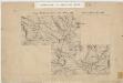
Maps of Nore og Uvdal

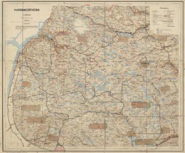
Hardangervidda
1 : 200000
Hardangervidda
1 : 200000
Hardangervidda

Statistikk 40-2: Oversiktskart over Hardangeviddas beiteforhold

Statistikk 40- Oversiktskart over Hardangeviddas beiteforhold

Trigonometrisk grunnlag, Squelet-Cart 4 Kart over de Sommeren 1846 trigonometrisk bestemte Punkter
C. Bassøe
Geologisk kart 111b: Hardangervidda - Flacheliefs
1 : 200000 P. U. Thomsen | K. Schipull Hamburger Geographische Studien
C34 nø/4
1 : 100000 Hjalmar Skaar
Kroki over en del av Haringvidda
1 : 100000 Finn Qvale
D34-1; D34-2; D34-7; D34-8
1 : 100000 Thorolv Ingar Ween
D34-3; D34-4; D34-8; D34-9; D34-10
1 : 100000 Thorolv Ingar Ween
Portefølje nr 28
1 : 100000 F. Sejersted | E. Lund
Museumskart 217-42: Specialkart over Hardangerfjorden. Østre del.
1 : 100000 M. T. Kingo | R. M. Petersen | H. N. Bergh Den Geografiske Opmaaling
Kroki over terrænet mellem Breifonn og Blyvardenuten
1 : 100000 Usmund Seim | Olaf Knutsen Garteig | Finn Qvale
Geologisk kart 111a: Hardangervidda - Höhenschichten
1 : 200000 K. Schipull | P. U. Thomsen Hamburger Geographische Studien
Portefølje nr 29
1 : 100000 W. Næser
Portefølje nr 29
1 : 100000 W. Næser
C33-4; C33-5; C34-10; C34-11
1 : 100000 Johannes Oliver Smith
D35
1 : 100000 Toralf Øyen
Spesielle kart 123-2: Kart over Drammensvassdraget
1 : 100000 Toralf à ̃yen
Kroki i 100000 over terrænet omkring Valdalen
1 : 100000 J. Rieck
17B 1; 17B 2; 17B 5; 17B 6; 17B 9; 17B 10; 17B 11; 17D 1; 17D 2; 17D 3
1 : 100000 H. Schauffenberg
17D 6; 17D 7; 17D 10; 17D 11
1 : 100000 Carl Christophersen
Trakten Litlos - Hansbu - Mogen
1 : 100000 Finn Qvale
D33 aust Hallingskarvet
1 : 100000
Sammensetning av deler av følgende kart utgitt av Norges geografiske oppmåling
1 : 100000
18A 2; 18A 3; 18A 4; 18A 6; 18A 7; 18A 8; 18A 11; 18A 12
1 : 100000 Magnus Engelschiøn
C33 aust Ulvik
1 : 100000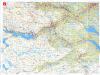
Turkart over Geilo
1 : 50000 Den norske turistforening | Ugland IT group