Maps of Nordkapp

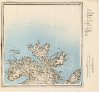
W1 Nordkap
1 : 100000 Ole Engh | Torgrim Lundtvedt
W1 Nordkap
1 : 100000
W1 Nordkap
1 : 100000 Ole Engh | Torgrim Lundtvedt
W1 Nordkap
1 : 100000 Ole Engh | Torgrim Lundtvedt
W1 Nordkap
1 : 100000 Ole Engh | Torgrim Lundtvedt
2137-3 Skarsvåg
1 : 50000 Statens kartverk
2037-2 Nordkapp
1 : 50000 Statens kartverk
2037-2 Nordkapp
1 : 50000 Statens kartverk
2037-2 Nordkapp
1 : 50000 Norges Geografiske Oppmåling
2037-2 Nordkapp
1 : 50000 Statens kartverk
2137-3 Kamöyfjorden
1 : 50000 Norges Geografiske Oppmåling
2137-3 Skarsvåg
1 : 50000 Statens kartverk
2037-2 Nordkapp
1 : 50000 Norges Geografiske Oppmåling
2137-3 Kamøyvær
1 : 50000 Statens kartverk
2137-3 Skarsvåg
1 : 50000 Norges Geografiske Oppmåling
W1 sørøstre del
1 : 50000 David Ebbesen | Finn Qvale
W1 sørvestre del
1 : 50000 Carl Ludvig Soelberg | David Ebbesen
V1 Hjelmsøy
1 : 100000 Ole Bernhard Tolstad | Carl Christian P. Olberg
W2 nordøstre del
1 : 50000 Georg Otto Lorange
Finmarkens amt 54b(2): Kart over Loppens Præstegd. eller Loppens og Hasvigs Sogne
1 : 200000 Gerhard Munthe, Fredrik Rode
Geologiske kart 121-V Kart med magnetisk totalfelt. Nordkapp
1 : 250000 Norges geologiske undersøkelse
Museumskart 217-18: Kart over Den Norske Kyst fra Nordkap til Tanahorn
1 : 50000 G. L. Fehr | Due | Hagerup | Rynning | Vibe | Klouman Opmaalings Directionen
Museumskart 19 kart over den Norske kyst fra Nordkapp til Tanahorn
1 : 200000 Vibe
Statistikk 36-2 nord: Ethnigrafisk Kart over Finmarkens Amt No 2
1 : 200000 Jens Andreas Friis
V1 Hjelmsø
1 : 100000 Ole Bernhard Tolstad | Carl Christian P. Olberg
V1 Hjelmsø
1 : 100000 Ole Bernhard Tolstad | Carl Christian P. Olberg
W2 Honningsvåg
1 : 100000 Johan Gulbrandsen Natrud | Ellef Nilsen
W2 Honningsvåg
1 : 100000
W2 Honningsvåg
1 : 100000