Maps of Sørfold

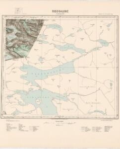
M12 Riddoalgge
1 : 100000
M12 Linnajavrre
1 : 100000
Geologisk kart 84: Geologisk kart: Linnajavrre
1 : 100000 Steinar Foslie Norges geologiske undersøkelse
M12 Linnajavrre
1 : 100000
2230-3 Linnajavrre
1 : 50000 Norges Geografiske Oppmåling
M12 nv
1 : 50000 Sigurd Sandvik
2230-3 Linájávri
1 : 50000 Statens kartverk
2230-3 Linnajávrre
1 : 50000 Statens kartverk
2229-4 Skagmadalen
1 : 50000 Statens kartverk
2229-4 Skagmadalen
1 : 50000 Statens kartverk
2229-4 Skagmadalen
1 : 50000 Statens kartverk
2230-3 Linájávri
1 : 50000 Statens kartverk
NRA GA 17
Thodal | Marelius | Mackuer | Krogh | Holm | Wetterstedt
2229-4 Skagmadal
1 : 50000 Norges Geografiske Oppmåling
Sulitjelma
1 : 250000 Bernh. Tolstad | O. Engh
Statistikk 43-22- Bosettingskart over Sulitjelma. Blad 22
1 : 250000 Statistisk Sentralbyrå
Geologiske kart 121-L: Kart med magnetisk totalfelt. Sulitjelma
1 : 250000 Norges geologiske undersøkelse
M11 Hellemobotn
1 : 100000 Torgrim Lundtvedt | Ole Engh
L12 nm
1 : 50000 William Steffens
M11 Hellemobotn
1 : 100000 Ole Engh | Torgrim Lundtvedt
2130-2 Gjerdalen
1 : 50000 Statens kartverk
2130-2 Gjerdal
1 : 50000 Norges Geografiske Oppmåling
2130-2 Mørsvikbotn
1 : 50000 Statens kartverk
L12 nm
1 : 50000 Sigurd Sandvik
Statistikk 43-22-2: Bosettingskart over Sulitjelma. Blad 22
1 : 250000 Statistisk Sentralbyrå
Spesielle kart 122-11: Postkart over Norge
1 : 400000 Toralf à ̃yen
Finmarkens amt nr 60: Charta öfver Twislige Riksskilnaden millan Sverige och Norje
1 : 20000 Laurent Lundgren, Per Tang
Statistikk 38-1 Bosettingskart over Troms og Norland. Blad 11
1 : 400000 Statistisk Sentralbyrå
Karta öfver Luleå Lappmark med en del af Norbottens Län
1 : 500000 författad af Franz von Schéele stentrijck af C. v. Schéele [S.l.] : C.M. af Robson