Maps of Porsanki

V3 nordøstre del
1 : 50000 Leif Broch
2036-3 Garddevarre
1 : 50000 Norges Geografiske Oppmåling
2036-3 Kokelv
1 : 50000 Statens kartverk
2036-3 Kokelv
1 : 50000 Norges Geografiske Oppmåling
2036-3 Kokelv
1 : 50000 Statens kartverk
2036-3 Kokelv
1 : 50000 Statens kartverk
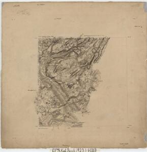
V3 nordøstre del
1 : 50000 Kaare Kvisgaard
V3 Repparfjord
1 : 100000
V3 Repparfjord
1 : 100000
V3 Repparfjord
1 : 100000
V3 Repparfjord
1 : 100000
V2
1 : 100000 Axel P. Printz | Alf Hattestad
V2
1 : 100000 Axel P. Printz
W3 Kistrand
1 : 100000
V3 nordvestre del
1 : 50000 Gunvald Hagene | Johannes Oliver Smith
V3 sørøstre del
1 : 50000 Ørnulf Bredo
Statistikk 36-2 nord: Ethnigrafisk Kart over Finmarkens Amt No 2
1 : 200000 Jens Andreas Friis
Statistikk 43-31-2: Bosettingskart over Honningsvåg. Blad 31
1 : 250000 Statistisk Sentralbyrå
Statistikk 43-31- Bosettingskart over Honningsvåg. Blad 31
1 : 250000 Statistisk Sentralbyrå
Museumskart 144: Kart over Den Norske Kyst fra Sørøen til Nordkap
1 : 200000 Klouman | Hagerup | Due | Vibe | Rynning
Finmarkens amt 54b(2): Kart over Loppens Præstegd. eller Loppens og Hasvigs Sogne
1 : 200000 Gerhard Munthe, Fredrik Rode
Museumskart 217-17: Kart over Den Norske Kyst fra Sørøen til Nordkap
1 : 50000 Due | Hagerup | Rynning | Vibe | Klouman | G. L. Fehr Opmaalings Directionen
Museumskart 190: Kart ovèr den norske kyst fra söröen til nordkap
1 : 200000 Vibe
Finmarkens amt 54e(3): kart over Alten-Talvigs Sogne
1 : 200000 Gerhard Munthe, Fredrik Rode
Finmarkens amt nr 58: Plan des environs de la colonne no 363 ou de Jakobsvig
1 : 8400 Mathias Andersen Ween
Statistikk 36-2 sør: Ethnigrafisk Kart over Finmarkens Amt No 2
1 : 200000 Jens Andreas Friis
Statistikk 38-14: Bosettingskart over Finnmark og Troms. Blad 14
1 : 400000 Statistisk Sentralbyrå
Spesielle kart 122-14: Postkart over Norge
1 : 400000 Toralf à ̃yen
Spesielle kart 122-15: Postkart over Norge
1 : 400000 Toralf à ̃yen