Maps of Rana

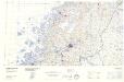
J15; sørvestre del
1 : 50000 Olav Herman Paulsen
1927-4 Sjona
1 : 50000 Norges Geografiske Oppmåling
1927-4 Sjona
1 : 50000 Statens kartverk
1927-4 Sjona
1 : 50000 Statens kartverk
1927-4 Sjona
1 : 50000 Statens kartverk
J15 Svartisen
1 : 100000 Torgrim Lundtvedt | Ole Engh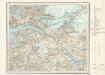
J15 Svartisen
1 : 100000
J15 Svartisen
1 : 100000 Torgrim Lundtvedt | Ole Engh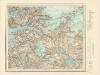
J15 Svartisen
1 : 100000
J15 Svartisen
1 : 100000
J15 Svartisen
1 : 100000 Torgrim Lundtvedt | Ole Engh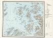
I15 Lurøy
1 : 100000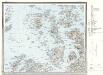
I15 Lurøy
1 : 100000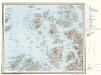
I15 Lurøy
1 : 100000
1928-3 Melfjorden
1 : 50000 Statens kartverk
1928-3 Melfjord
1 : 50000 Norges Geografiske Oppmåling
J16 nordvestre del; versjon 1
1 : 50000 Georg Peter L. Mamen
63A 11
1 : 50000 Johan Ferdinand Normann
J15 nordvestre del
1 : 50000 Harald Ingvar Johannessen
J15 sørøstre del
1 : 50000 Olav Herman Paulsen
Rana
1 : 250000 Bernh. Tolstad | O. Engh
Geologiske kart 121-S: Kart med magnetisk totalfelt. Mo i Rana
1 : 250000 Norges geologiske undersøkelse
Rana
1 : 250000 Bernh. Tolstad | O. Engh
Rana
1 : 250000 Bernh. Tolstad | O. Engh
Rana
1 : 250000 Bernh. Tolstad | O. Engh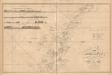
Museumskart 217-12: Kart over den Norske Kyst fra Dønnæsøe til Fleina og Sandhornet
1 : 50000 H. Paludan | Hagerup | G. L. Fehr | Vibe Opmaalings Directionen
Geologisk kart 54: Geologisk Generalkart; Træna
1 : 250000 J. Rekstad Norges geologiske undersøkelse
Museumskart 136: Kart over Den Norske Kyst fra Dønnæsøe til Fleina og Sandhornet
1 : 200000 H. Paludan | Hagerup | Vibe
Statistikk 43-20- Bosettingskart over Mo i Rana. Blad 20
1 : 250000 Statistisk Sentralbyrå