Maps of Løten

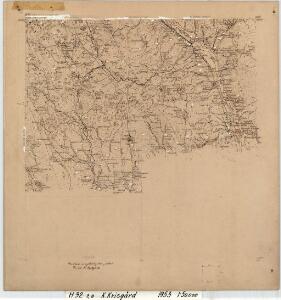
H32-7; H32-8
1 : 50000 Kaare Kvisgaard
H32-7; H32-8
1 : 50000 Kaare Kvisgaard
1916-1 Löten
1 : 50000 Statens kartverk
1916-1 Løten
1 : 50000 Statens kartverk
1916-1 Løten
1 : 50000 Statens kartverk
1916-1 Löten
1 : 50000 Norges Geografiske Oppmåling
1916-1 Løten
1 : 50000 Statens kartverk
H32-1; H32-7
1 : 25000 Erik Christensen
Ekserserplasskart; Terningmoen-nv
Per Hovdn
26C 4
1 : 50000 Johannes Solem
26C 3
1 : 50000 Johannes Solem
26A 11
1 : 50000 Grimsoth
26C 3
1 : 50000 Johannes Solem
26C 4
1 : 50000 Johannes Solem
26A 11
1 : 20000 Jørgen Scielderup Grimseth
26A 12
1 : 50000 Frithjof Jacobsen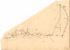
Fra Smedbakken via Terningen til Foss
1 : 20000 J. H. Reichborn
H32-1; H32-7
1 : 25000 Kaare Kvisgaard
Kartblad VI: Vei-kaart over den trondhjemske Kongevei fra Christiania til Røraas gjennom Eidsvold, Rommedal, Levthen og Østerdalen
1 : 20000 J. H. Reichborn
H32-1; H32-7
1 : 25000 Kaare Kvisgaard
Fra Grundset til Johannesstua
1 : 20000 J. H. Reichborn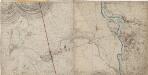
26A 12 øst
1 : 10000 Heide | Johan Friderich Næser | Dorph
26A 12 vest
1 : 10000 Heide | Johan Friderich Næser | Dorph
26A 12 sør
1 : 10000 Johan Friderich Næser | Dorph | Heide
26A 12 nord
1 : 10000 Dorph | Johan Friderich Næser | Heide
26C 4 vest
1 : 10000
Mil nr 173
1 : 10000 Johan Henrich Ramm | Hans Lemmich Juell
Mil nr 183
1 : 10000 Johan Henrich Ramm | Eilert Woldemar Preben Ramm
26C 4 øst
1 : 10000