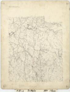
Maps of Løten

H32-1; H32-2
1 : 50000 Andreas Theodor Walle
H32-1; H32-2
1 : 50000 Andreas Theodor Walle
26A 7 n
1 : 50000
26A 7
1 : 50000 Grimsoth
26A 7
1 : 20000 Jørgen Scielderup Grimseth
Fra Harstad til Frønset
1 : 20000 J. H. Reichborn
Kartblad V: Vei-kaart over den trondhjemske Kongevei fra Christiania til Røraas gjennom Eidsvold, Rommedal, Levthen og Østerdalen
1 : 20000 J. H. Reichborn
Fra Kollovangen til Løken
1 : 20000 J. H. Reichborn
26A 8 vest
1 : 10000 Narenst | Lund
26A 8 nv
1 : 10000
26A 8 sv
1 : 10000
Ekserserplasskart; Terningmoen-sv
Per Hovdn
26A 3
1 : 20000 Jørgen Scielderup Grimseth
H32-1; H32-7
1 : 25000 Kaare Kvisgaard
H32-1; H32-7
1 : 25000 Kaare Kvisgaard
Hedemarkens amt nr 59b: Kart over Stange St. med omgivelser
1 : 2000 Nicolai Solner Krum
Hedemarkens amt nr 59a: Kart over LÃ ̧iten St. med omgivelser
1 : 2000 Nicolai Solner Krum
Geologiske kart 26: Den geologiske Undersøgelse, Hamar
1 : 100000 M. Irgens | P. Krohn | Alfred Getz | F. Jacobsen | J. Vogt | Theodor Kjerulf Norges geologiske undersøkelse
26A Hamar
1 : 100000 F. Jacobsen | C. Pedersen
26A Hamar
1 : 100000
26A Hamar
1 : 100000 Ole Engh | F. Jacobsen
26A Hamar
1 : 100000 F. Jacobsen | Ole Engh
26A Hamar
1 : 100000 Ole Engh | F. Jacobsen
26A Hamar
1 : 100000 F. Jacobsen | Ole Engh
26A Hamar
1 : 100000
26A Hamar
1 : 100000 F. Jacobsen
1916-1 Löten
1 : 50000 Norges Geografiske Oppmåling
Kartblad 49b: Geographisk Charte over Conturen af det Leuthenske mig Allernaadigst anbetroede Compagnie
Rick
1916-2 Tangen
1 : 50000 Norges Geografiske Oppmåling