Maps of Øyer

G31-7
1 : 50000 Alf Hattestad
Fra Jørstad til Einstad
J. H. Reichborn
Kartblad nr 5: Kaart over Postveien fra Korsødegaarden til Trondhjem igjennom Gulbrandsdalen over Dovrefjeld
1 : 20000 J. H. Reichborn
Fra Skardsmoen til Mågåli
1 : 20000 J. H. Reichborn
Kartblad 6: Kart over Veien fra Eidsvold til Gausdal og til Skydsstationen Holmen i Øyer
J. H. Reichborn
31B 2
1 : 50000 Hans Christian Smith Due
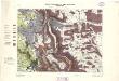
Kart over de Mærkesatte Slaatter i Øiers Statsalmenning
1 : 10000 Fr. Matzow
G31-7; G31-8
1 : 50000 A. H.
Kartblad 62: Charte over det Faabergske Compagnie District

31B 2; 31B 3; 31B 6; 31B 7
1 : 100000
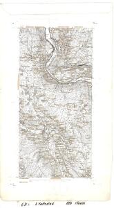
1817-4 Fåvang
1 : 50000 Statens kartverk
31B 3
1 : 50000 Johan Lauritz Bull
G31-1
1 : 40000 Alf Hattestad
25D 10
1 : 50000 Ramm
25D 10
1 : 50000 Johan Ferdinand Normann
F31-12
1 : 50000 Berthold Dahl
Fra Einsby til Gillebu
1 : 20000 J. H. Reichborn
Kartblad nr 4: Kaart over Postveien fra Korsødegaarden til Trondhjem igjennom Gulbrandsdalen over Dovrefjeld
1 : 20000 J. H. Reichborn
25D 10
1 : 50000 Johan Ferdinand Normann
31B 6
1 : 50000 Johan Lauritz Bull
25D 11
1 : 50000 Øvergaard | Hans Christian Smith Due | Johan Ferdinand Normann
25D 11
1 : 50000
F31-12
1 : 50000 Hans Knagenhjelm Hertzberg
31B 7
1 : 50000 Johan Lauritz Bull
Kartblad 52: Militært Cart over det Gusdalske Compagnies District
Keilhau
Portefølje nr 47
1 : 100000 Duncker | Munthe
Portefølje nr 47
1 : 100000 Duncker | Munthe
5527 Lillehammer
1 : 100000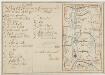
Kartblad 58: Carte over det Ringeboiske Compagnie District
Jens Bull | Kraft