Maps of Krødsherad

F34-8
1 : 50000 Ole Saastad
F34-8
1 : 50000 Fredrik Sophus Ringe
F34-9, F34-10
1 : 50000 Einar C. I. N. Michelsen | Ingvald M. E. Smith-Kjelland
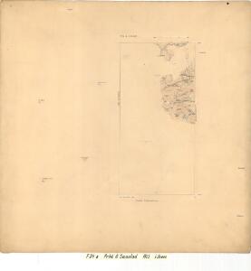
1715-4 Flå
1 : 50000 Statens kartverk
1715-4 Flå
1 : 50000 Norges Geografiske Oppmåling
19C 2; 19C 3
1 : 50000 Lund
19A 10; 19A 11
1 : 50000 Lund
F34-7, F34-8
1 : 50000 Berthold Dahl | Leif Broch
F34-7, F34-8
1 : 50000 Berthold Dahl
F34-9
1 : 50000 Einar C. I. N. Michelsen
F34-7
1 : 50000 Leif Broch
1715-4 Fla
1 : 50000 Norges Geografiske Oppmåling
1715-4 Flå
1 : 50000 Statens kartverk
1715-4 Flå
1 : 50000 Statens kartverk
F34 vest Sigdal
1 : 100000
F34 vest Sigdal
1 : 100000
F34 Krøderen
1 : 100000 Ole Tolstad | Ellef Nilsen
F34 vest Sigdal
1 : 100000
Portefølje nr 30
1 : 100000 J. C. Richter
Portefølje nr 30
1 : 100000 Gedde
Spesielle kart 58-2: Kart over Drammenselvens Flødningsdistrikt
1 : 100000 Thurmann | Seip
Spesielle kart 123-5: Kart over Drammensvassdraget
1 : 100000 Toralf à ̃yen
Kartblad 32: Vej-Cart over det Nummedahlske Compagnie District
V. Dietrichs | Bruenech
Kartblad 31-2: Chart over det Numedahlsche Compagnie District
S. Selboe
Spesielle kart 23: Vestbanerne, Christiania-Drammen-Randsfjord-Kongsberg-Krøderen og Drammen-Laurvik-Skien
1 : 400000 Albert Cammermeyer Forlag
Kartblad 63 øst: Det yttere Hallingdahlske Infanterie Compagnie District

Spesielle kart 3: Kart over Drammen-Randsfjordjernbanen og de projecterede Linier til Kongseberg og Krøderen med Profil over Banens Stigningsforholde
1 : 200000 Harald Lyches Forlag
Spesielle kart 23-2: Vestbanerne, Christiania-Drammen-Randsfjord-Kongsberg
1 : 400000 Albert Cammermeyer Forlag
Hallingdal
1 : 250000