Maps of Melhus

F25-12-mø/6, G25-7
1 : 25000 Alf Hattestad
F25-12-nø/6
1 : 25000 Gustav Adolf Tajet
Trondheim omegn
1 : 25000 NGO
Fra Kvål til Nordre Jaktøya
1 : 20000 J. H. Reichborn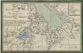
Kartblad 178: Kart over Konge- Post- og Alfar-Weiene igiennom det Byenæsiske Compagnie under det Trondhiemske Dragonregiment
1 : 60000
Kartblad 94: Wey-Carte over det Melhusiske Compagnie District

G25-7-nv/6
1 : 25000 Thorleif Dagfinn Unneberg
G25-7-mø/6
1 : 25000 Alf Hattestad
G25-7-nø/6
1 : 25000 Erling Bjørstad
Kartblad 177: Kort over Konge- Post- og Alfar-Weiene igjennem det Melhusske Compagnie under det Trondhiemske Dragonregiment
1 : 60000
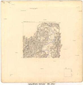
Melhus med omegn
1 : 25000 Reinhold Ziegler
46B Melhus
1 : 100000 Arnt Magnus Andreassen Øgaard | C. Pedersen
46B Melhus
1 : 100000
46B Melhus
1 : 100000 C. Pedersen | Arnt Magnus Andreassen Øgaard
46B Melhus
1 : 100000 C. Pedersen | Arnt Magnus Andreassen Øgaard
46B Melhus
1 : 100000 C. Pedersen | Arnt Magnus Andreassen Øgaard
46B Melhus
1 : 100000
46B Melhus
1 : 100000 C. Pedersen | Arnt Magnus Andreassen Øgaard
46B Melhus
1 : 100000 C. Pedersen | Arnt Magnus Andreassen Øgaard
46B Melhus
1 : 100000
Kartblad 103: Carte over det Budwigske Compagnie District
Ræder
Kartblad 95: Det Stadsbøidiske Compagnie District

46B 1; 46B 2; 46B 3; 46B 4; 46B 5; 46B 6; 46B 7; 46B 8
1 : 50000 Fredrik Christian Sejersted
Geologiske kart 15: Den geologiske Undersøgelse, Melhus
1 : 100000 Theodor Kjerulf | J. Vogt | H. T. Bjørnstad | M. Bugge | C. Schultz Norges geologiske undersøkelse
Spesielle kart 22-1: Rognæs - Trondheim
1 : 400000 Albert Cammermeyer Forlag
Kartblad 10 Situations Cart over det Børsensche Compagnies Destrichte
Casper Fridrich von Brodtkorb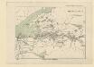
Spesielle kart 25: Merakerbanen
1 : 400000 Albert Cammermeyer Forlag
Trigonometrisk grunnlag, Squelet-Cart 56: kart over de i Sommeren 1859 bestemte Punkter
A. Heiberg
Trigonometrisk grunnlag, Squelet-Cart 65-16