Maps of Seljord

E36-8, E36-9
1 : 50000 Adler Gleditsch
E36 vest Kviteseid
1 : 100000
E36 vest Kviteseid
1 : 100000
Geologisk kart 84: Geologisk kart, Kviteseid
1 : 100000 Henrich Neumann | Johannes A. Dons Norges geologiske undersøkelse
E36 vest Kviteseid
1 : 100000
Kartblad 21 vest- Geographisk Kart over det Hjerdalske Compagnie District; vestre del versjon 1
Mathias Andreas Rye
1614-3 Hjartdal
1 : 50000 Statens kartverk
1614-3 Hjartdal
1 : 50000 Norges Geografiske Oppmåling
1614-3 Flatdal
1 : 50000 Norges Geografiske Oppmåling
1614-3 Hjartdal
1 : 50000 Statens kartverk
1614-3 Hjartdal
1 : 50000 Statens kartverk
13B 9; 13D 1
1 : 50000 J. H. Aas
Kartblad 21-2: Geographisk Kart over det Hjerdalske Compagnie District; versjon 2
Mathias Andreas Rye
Kartblad 20: Det Bøherredske Compagnie District
Hans M. Grønvold
Geologiske kart 45: Geologisk kart over Østtelemarken
1 : 300000 Kjerulf | W. Werenskiold | Tellef Dahll
Portefølje nr 21
1 : 100000 H. Lassen
Portefølje nr 21
1 : 100000 H. Lassen
Kartblad 21 øst-2: Geographisk Kart over det Hjerdalske Compagnie District; østre del versjon 1
Mathias Andreas Rye
Kartblad 145 øst: Cart over det 2det Westfieldske øwre Tellemarkske Compagnie District; østre del
Koss
1514-2 Åmotsdal
1 : 50000 Norges Geografiske Oppmåling
1514-2 Åmotsdal
1 : 50000 Statens kartverk
E36 aust Lifjell
1 : 100000
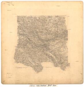
E36-4 n/2; E36-10 s/2
1 : 50000 Hjalmar Skaar
E36-10, E36-11
1 : 50000 Adler Gleditsch
Lifjell
1 : 50000 Statens Kartverk
13A 4; 13A 8; 13B 1; 13B 5
1 : 50000 Paul Hansen Birch Brun
13B 10; 13B 11; 13D 2; 13D 3
1 : 50000 Ludvig Andreas Riis
1514-2 Åmotsdal
1 : 50000 Statens kartverk
1514-2 Åmotsdal
1 : 50000 Norges Geografiske Oppmåling