Maps of Etne

C35-7; C35-8
1 : 50000 N. Houge
1314-4 Fjæra
1 : 50000 Statens kartverk
1314-4 Fjæra
1 : 50000 Norges Geografiske Oppmåling
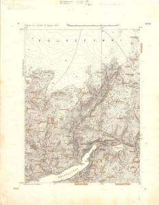
1314-4 Åkrafjorden
1 : 50000 Statens kartverk
1314-4 Fjæra
1 : 50000 Statens kartverk
C35 vest Fjæra
1 : 50000
B35-12
1 : 50000 Niels Sire
17A 2; 17A 3; 17A 4; 17A 8; 17A 12 (geometrisk hovednet)
1 : 100000 Fr. Sejersted
17A 6; 17A 7; 17A 10; 17A 11
1 : 100000 Fougner
Kroki i 100000 over terrænet omkring Valdalen
1 : 100000 J. Rieck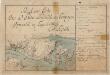
Kartblad 130-2: Situations Carte over det Søndre Sundhordlehnske Compagnie District; versjon 2
Lorentz Henrik Møller Segelcke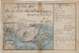
Kartblad 130- Situations Carte over det Søndre Sundhordlehnske Compagnie District; versjon 1
Lorentz Henrik Møller Segelcke
17A 2; 17A 3; 17A 4; 17A 8; 17A 12
1 : 100000 Fr. Sejersted
Portefølje nr 19
1 : 100000 E. Lund
Sammensetning av deler av følgende kart utgitt av Norges geografiske oppmåling
1 : 100000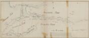
Kartblad 159: Det Skaanevigske; Captain von Voigts Compagnie

Museumskart 217-4 Specialkart over Hardangerfjorden. Vestre del.
1 : 100000 M. T. Kingo | H. N. Bergh | R. M. Petersen Den Geografiske Opmaaling
B35 aust Skaanevik
1 : 100000
1315-3 Odda
1 : 50000 Statens kartverk
1315-3 Odda
1 : 50000 Statens kartverk
1315-3 Odda
1 : 50000 Statens kartverk
1315-3 Odda
1 : 50000 Norges Geografiske Oppmåling
B35-11; B35-12
1 : 50000 Kjeld Andreas Bugge
12C 6; 12C 7; 12C 10; 12C 11
1 : 50000 E. Lund
C34-1; C34-2; C34-7; C34-8
1 : 50000 Sigurd L. N. Hauge | Kaare Kvisgaard
1214-1 Kvinnherad
1 : 50000 Statens kartverk
1214-1 Kvinnherad
1 : 50000 Norges Geografiske Oppmåling
1214-1 Kvinnherad
1 : 50000 Statens kartverk
C34-2; C34-3; C34-4
1 : 50000 Hjalmar Skaar | Axel P. Printz