Maps of Tysfjord

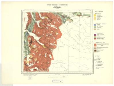
Geologisk kart 8 Geologisk kart: Hellembotn
1 : 100000 Steinar Foslie Norges geologiske undersøkelse
M11 Hellemobotn
1 : 100000 Ole Engh | Torgrim Lundtvedt
M11 Hellemobotn
1 : 100000
M11 Hellemobotn
1 : 100000 Torgrim Lundtvedt | Ole Engh
M11 Hellemobotn
1 : 100000 Torgrim Lundtvedt | Ole Engh
2230-1 Björntoppen
1 : 50000 Norges Geografiske Oppmåling
2230-1 Björntoppen
1 : 50000 Norges Geografiske Oppmåling
2230-4 Vuodnabahta
1 : 50000 Statens kartverk
2230-4 Hellemobotn
1 : 50000 Statens kartverk
2230-4 Hellemobotn
1 : 50000 Norges Geografiske Oppmåling
2230-4 Hellemobotn
1 : 50000 Norges Geografiske Oppmåling
2230-1 Bjørntoppen
1 : 50000 Statens kartverk
M11; sørvestre del
1 : 50000 Kjeld Andreas Bugge
M11 nordre del
1 : 50000 Erling Bjørstad
M11; nordvestre del
1 : 50000 Kjeld Andreas Bugge
2230-1 Bjørntoppen
1 : 50000 Statens kartverk
2230-1 Bjørntoppen
1 : 50000 Statens kartverk
L11 nordøstre del
1 : 50000 Henrik Christian Rørholt | Thorleif Barlag
2230-3 Linájávri
1 : 50000 Statens kartverk
2230-3 Linnajávrre
1 : 50000 Statens kartverk
2230-3 Linnajavrre
1 : 50000 Norges Geografiske Oppmåling
2230-3 Linájávri
1 : 50000 Statens kartverk
M10; sørøstre del
1 : 50000 Ole Berg Getz | Sven Nielsen
Statistikk 43-22- Bosettingskart over Sulitjelma. Blad 22
1 : 250000 Statistisk Sentralbyrå
NRA GA 18
Thodal | Mackuer | Krogh | Marelius | Holm | Wetterstedt
Geologiske kart 121-L: Kart med magnetisk totalfelt. Sulitjelma
1 : 250000 Norges geologiske undersøkelse
Statistikk 43-22-2: Bosettingskart over Sulitjelma. Blad 22
1 : 250000 Statistisk Sentralbyrå
Sulitjelma
1 : 250000 Bernh. Tolstad | O. Engh
NRA GA 17
Thodal | Marelius | Mackuer | Krogh | Holm | Wetterstedt