Maps of Grimstad

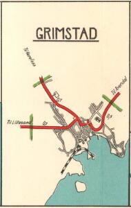
Grimstad
1 : 15000 P. M. Bye og Co. AS Oslo
Grimstad
1 : 2500 Søren Christian Gjessing
Museumskart 62: Kart over Indseilingen til Grimstad
1 : 25000 H. Wille Grimstads Sømands- og Handelsforening
5A 8 5A 12
1 : 50000 Birger Hielm
1611-4 Arendal
1 : 50000 Norges Geografiske Oppmåling
1611-4 Arendal
1 : 50000 Statens kartverk
1611-4 Arendal
1 : 50000 Statens kartverk
1611-4 Arendal
1 : 50000 Norges Geografiske Oppmåling
5B 5 5B 9 5B 10
1 : 50000 Ph. Sissener
1611-4 Arendal
1 : 50000 Norges Geografiske Oppmåling
5B 9 5B 10
1 : 50000 Johannes Solem
1611-4 Arendal
1 : 50000 Statens kartverk
E39 vest Froland
1 : 100000
E39 vest Froland
1 : 100000
5B Grimstad
1 : 100000 H. C. Wanggård | Arnt Magnus Andreassen Øgaard
5B Grimstad
1 : 100000 H. Hagen | Arnt Magnus Andreassen Øgaard
E39 vest Froland
1 : 100000
Kartblad 140: Vej-Kart over det 2det Nedenæsske Compagnie District
M. Kuur
5B Grimstad
1 : 100000
E39 vest Froland
1 : 100000
5A Kristiansand
1 : 100000
Museumskart 60b: Kart over strekningen Kristiansand-Risør
1 : 200000 Rasmus Iuel
5A Kristiansand
1 : 100000 Daniel Tønnesen | H. C. Wanggård
5A Kristiansand
1 : 100000 C. Pedersen | Daniel Tønnesen
5B Grimstad
1 : 100000 H. Hagen | Arnt Magnus Andreassen Øgaard
Portefølje nr 3
1 : 100000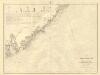
Museumskart 217-24: Kart over Den Norske Kyst fra Arendal til Christiansand
1 : 50000 H. Wille | C. Diriks | Vibe Opmaalings Directionen
Trigonometrisk grunnlag, Squelet-Cart 19- Kysten fra Kragerø til Tromøy
B. Aubert | Niels Andreas Wibe
Trigonometrisk grunnlag, Squelet-Cart 19-2: Kysten fra Kragerø til Tromøy
Niels Andreas Wibe | B. Aubert