Maps of Porsanki

Finmarkens amt 54e(3): kart over Alten-Talvigs Sogne
1 : 200000 Gerhard Munthe, Fredrik Rode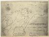
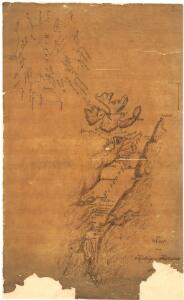
Finmarkens amt nr 58: Plan des environs de la colonne no 363 ou de Jakobsvig
1 : 8400 Mathias Andersen Ween
Finmarkens amt 54b(2): Kart over Loppens Præstegd. eller Loppens og Hasvigs Sogne
1 : 200000 Gerhard Munthe, Fredrik Rode
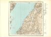
Museumskart 190: Kart ovèr den norske kyst fra söröen til nordkap
1 : 200000 Vibe
Museumskart 217-17: Kart over Den Norske Kyst fra Sørøen til Nordkap
1 : 50000 Due | Hagerup | Rynning | Vibe | Klouman | G. L. Fehr Opmaalings Directionen
Museumskart 144: Kart over Den Norske Kyst fra Sørøen til Nordkap
1 : 200000 Klouman | Hagerup | Due | Vibe | Rynning
Statistikk 43-31-2: Bosettingskart over Honningsvåg. Blad 31
1 : 250000 Statistisk Sentralbyrå
Statistikk 43-31- Bosettingskart over Honningsvåg. Blad 31
1 : 250000 Statistisk Sentralbyrå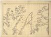
Statistikk 36-2 nord: Ethnigrafisk Kart over Finmarkens Amt No 2
1 : 200000 Jens Andreas Friis
V2
1 : 100000 Axel P. Printz | Alf Hattestad
V2
1 : 100000 Axel P. Printz
Geologisk kart 125: Børselvfjellet - Lille Porsangen, Nord-Norge
1 : 75000 J. L. Sollid | K. J. Kristiansen Geografisk institutt, Universitetet i Oslo
V4
1 : 100000 Thorleif Barlag
V1 Hjelmsø
1 : 100000 Ole Bernhard Tolstad | Carl Christian P. Olberg
V4 nordre del; V3 2 og 3
1 : 100000 Per Tang
W1 Nordkap
1 : 100000 Ole Engh | Torgrim Lundtvedt
V1 Hjelmsø
1 : 100000 Ole Bernhard Tolstad | Carl Christian P. Olberg
V3 Repparfjord
1 : 100000
W1 Nordkap
1 : 100000 Ole Engh | Torgrim Lundtvedt
W4 Børselv
1 : 100000
W4 Børselv
1 : 100000
V4 Stabbursdalen
1 : 100000
V2 Havøysund
1 : 100000
V1 Hjelmsøy
1 : 100000 Ole Bernhard Tolstad | Carl Christian P. Olberg
V3 Repparfjord
1 : 100000
W2 Honningsvåg
1 : 100000 Johan Gulbrandsen Natrud | Ellef Nilsen
V3 Repparfjord
1 : 100000
W3 Kistrand
1 : 100000
V4 Stabbursdalen
1 : 100000