Maps of South Varanki

Finmarkens amt 48-R: Grændserà ̧skarter, optagne under Grændserydningerne 1896 og 1897
1 : 8400 M. A. Ween
Finmarkens amt 48-Q1: Grændserà ̧skarter, optagne under Grændserydningerne 1896 og 1897
1 : 8400 M. A. Ween
Spesielle kart 172-15: Kart over riksgrensen mellom Norge og Finland
1 : 40000 Kristian Nissen | Gleditsch | Arvo Manner | K. Vaala
89C 10; 89C 11; 96A 2; 96A 3
1 : 100000 Aksel Hvide Bang
2333-1 Vaggatem
1 : 50000 Norges Geografiske Oppmåling
2333-1 Vaggatem
1 : 50000 Norges Geografiske Oppmåling
2333-1 Vaggatem
1 : 50000 Norges Geografiske Oppmåling
2333-1 Vaggatem
1 : 50000 Statens kartverk
2333-1 Store Spurvvatnet
1 : 50000 Statens kartverk
2334-2 Neiden
1 : 50000 Statens kartverk
2333-1 Vaggatem
1 : 50000 Statens kartverk
2334-2 Neiden
1 : 50000 Norges Geografiske Oppmåling
2334-2 Neiden
1 : 50000 Statens kartverk
Æ6 Svanvik
1 : 100000
Æ6 Svanvik
1 : 100000 Ole Engh | Johan Gulbrandsen Natrud
Æ6 Svanvik
1 : 100000 Ole Engh | Johan Gulbrandsen Natrud
Æ6 Svanvik
1 : 100000 Johan Gulbrandsen Natrud | Ole Engh
Æ6
1 : 100000 Bent Eskildssøn Bentzen
Æ6 Svanvik
1 : 100000
Æ6 Svanvik
1 : 100000 Johan Nordhagen | Johan Gulbrandsen Natrud
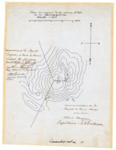
Røis 349-363-2
Mejlander | Calamus
Statistikk 43-29- Bosettingskart over Kirkenes. Blad 29
1 : 250000 Statistisk Sentralbyrå
Statistikk 43-29-2: Bosettingskart over Kirkenes. Blad 29
1 : 250000 Statistisk Sentralbyrå
Petsamo ympäristöineen
1 : 400000 Finsko severní Maanmittaushallituksen kivipaino
Spesielle kart 122-15: Postkart over Norge
1 : 400000 Toralf à ̃yen
Statistikk 38-15: Bosettingskart over Finnmark. Blad 15
1 : 400000 Statistisk Sentralbyrå
Geologisk kart 120: Features of the Glacial Geology of Finnmark
1 : 300000 O. Kjeldsen | O. Salvigsen | S. Sturød | T. Tveitå | A. Wilhelmsen | J. L. Sollid | S. Andersen | N. Hamre Norsk geografisk tidsskrift
Spesielle kart 110-4: Hydrografisk kart over det nordlige Norge
1 : 500000 G. Sætren
Skogkart paa grundlag av det Hydrografiske kart, blad 8
1 : 500000 Kaptein K. Gleditsch