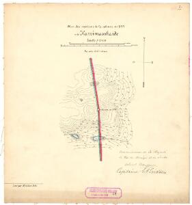
Maps of Teno

Finmarkens amt 48-K1: Grændserà ̧skarter, optagne under Grændserydningerne 1896 og 1897
1 : 8400 M. A. Ween
Spesielle kart 172b-20: Kart over riksgrensen mellom Norge og Finland på grunnlag av luftfotografier
1 : 20000 Arvo Manner | Kristian Nissen | Gleditsch | K. Vaala
Spesielle kart 172-12: Kart over riksgrensen mellom Norge og Finland
1 : 40000 Kristian Nissen | Gleditsch | Arvo Manner | K. Vaala
2235-2 Polmak
1 : 50000 Statens kartverk
2235-2 Polmak
1 : 50000 Norges Geografiske Oppmåling
2235-2 Deanušaldi
1 : 50000 Statens kartverk
2235-2 Polmak
1 : 50000 Statens kartverk
2235-2 Polmak
1 : 50000 Norges Geografiske Oppmåling
95D 9; 101B 1
1 : 100000 Johan Ferdinand Normann
95D 9
1 : 100000 Johan Ferdinand Normann
95D 5; 95D 6; 95D 9; 95D 10
1 : 100000 Daniel Tønnesen
Y4 Polmak
1 : 100000 Arnt Magnus Andreassen Øgaard | Ole Engh
Y4 Polmak
1 : 100000 H. C. Wanggård | Arnt Magnus Andreassen Øgaard
Y4 Polmak
1 : 100000 Ole Engh | Arnt Magnus Andreassen Øgaard
Y4 Polmak
1 : 100000 H. C. Wanggård | Arnt Magnus Andreassen Øgaard
Y4 Polmak
1 : 100000
Y4 Polmak
1 : 100000
Y4 Polmak
1 : 100000
Z4 Nesseby
1 : 100000 Ole Tolstad | C. Pedersen
Røis 343-349
Mejlander | Calamus
Y4 Polmak
1 : 100000 Arnt Magnus Andreassen Øgaard | H. C. Wanggård
Z4 Næsseby
1 : 100000 Ole Tolstad | Carl Christian P. Olberg
Y5 Bievra
1 : 100000 Ole Engh | Oluf Lier
NRA GA 23
Wetterstedt | Thodal | Halldin | Krogh | Wessaman | Holm
Finmarkens amt nr 6: Situations Kort over Finmarken og dens Grændser
1 : 600000 H. J. Broch
Statistikk 43-31-2: Bosettingskart over Honningsvåg. Blad 31
1 : 250000 Statistisk Sentralbyrå
Statistikk 43-31- Bosettingskart over Honningsvåg. Blad 31
1 : 250000 Statistisk Sentralbyrå
Statistikk 43-28- Bosettingskart over Karasjok. Blad 28
1 : 250000 Statistisk Sentralbyrå
Trigonometrisk grunnlag, Squelet-Cart 59
Haffner