Maps of Jerez de la Frontera

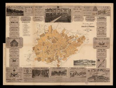
Plano industrial y comercial de la ciudad de Jerez de la Frontera / propiedad de J. Calvet y Boix
1 : 5000 Calvet y Boix, Juan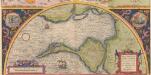
Hanc Insulam Perlustrabat [... Cadiz und Küste] [Karte], in: Theatrum orbis terrarum, S. 60.
1 Karte aus Atlas Ortelius, Abraham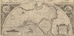
Hanc Insulam Perlustrabat [...] [Cadiz und Küste] [Karte], in: Theatrum orbis terrarum, S. 107.
1 Karte aus Atlas Ortelius, Abraham Vrients, Jan Baptista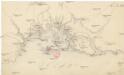
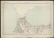
[Cádiz a okolí]
Andalusie (Španělsko)
A plan of the city of Cadis and the environs, with the harbour, bay and soundings at lon water also a particular plan of the town and fortifications, from the collection of Capt. Clarck and improved by the late John Rocque, topographer to his Majesty
Rocque, John ; Clarck, capt.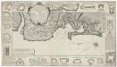
Plan de la baye et ville de Cadis de la riviere de St. Lucas de Barameda de ses environs
Beaurain
[Cádiz a okolí]
Andalusie (Španělsko)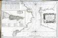
Carte du détroit de Gibraltar
1 Karte : Kupferdruck ; 56 x 87 cm Bellin s.n.
Accurate Vorstellung der berühmten Meers-Enge bey Gibraltar
1 Karte : Kupferdruck ; 32 x 25 cm, Bildgrösse 47 x 56 cm Homännische Erben
Castellum Gibraltar in Andalusia situm
1 Karte : Kupferdruck ; 26 x 32 cm, Bildgrösse 48 x 59 cm Lotter T. K. Lotter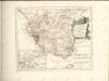
Des Koenigreichs Sevilla...

Nouvelle carte du détroit de Gibraltar et de l'isle de Cadix
1 Karte : Kupferdruck ; 54 x 46 cm Santini; Remondini chez M.r Remondini
Plan topo-hydrographique du détroit de Gibraltar
1 Karte : Kupferdruck ; 44 x 53 cm Vezou; Lattré; Lynslager chez Lattré graveur rue St. Jacques vis-a-vis celle de la parcheminerie à la ville de Bordeaux

Carte nouvelle de l'isle de Cadix [et] du detroit de Gibraltar
1 Karte : Kupferdruck ; 55 x 47 cm Weidler; Petit; Schneider Homännische Erben
Accurata designatio celebris freti prope Andalusiæ castellum Gibraltar. inter in Europam et Africam
1 Karte : Kupferdruck ; 36 x 56 cm, Bildgrösse 48 x 56 cm Seutter Matthäus Seutter
Mappa ou carta geographica dos reinos de Portugal e Algarve, 6
1 Blatt : 55 x 44 cm Dury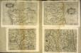
Hispalensis conventvs delineatio
1 Karte : Kupferdruck ; 14 x 18 cm Lambert Andreae
Hispalensis conventvs delineatio
1 Karte : Kupferdruck ; 33 x 43 cm Chaves; Ortelius s.n.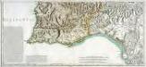
Mapa general del reyno de Portugal, 4
2 Blätter : 35 x 78 cm Tomás López
Hispalensis Conventus Delineatio [Karte], in: Theatrum orbis terrarum, S. 101.
1 Karte aus Atlas Ortelius, Abraham Vrients, Jan Baptista
Mapa del reyno de Sevilla
1 Karte auf 4 Blättern : Kupferdruck ; 74 x 71 cm López; Ellobet s.n.
Hispalensis Conventus Delineatio [Karte], in: Theatrum orbis terrarum, S. 54.
1 Karte aus Atlas Ortelius, Abraham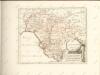
Maroc (500 000 e). Tanger
1 : 500000 France. Service géographique de l'armée Service géographique de l'Armée
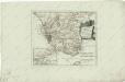
Sevilla regnum in suas archiepiscopatos episcopatos et praefecturas divisum
1 Karte : Kupferdruck ; 42 x 55 cm Güssefeld; López; Ellobet; Hauer Homännische Erben
Carte nouvelle De L'ISLE de CADIX & du Detroit de GIBRALTAR
1 : 500000 Cádiz (Španělsko) Petit, Jean de Schneider, Ruprecht A. Weidler
Carte nouvelle de l'Isle de Cadix & du Detroit de Gibraltar
1 : 390000 Cádiz (Španělsko) Petit, Jean de aux depens des Heritiers du feu m. le docteur Homann