Maps of Europe

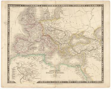
Ancient Roman empire
J. Dower Henry Teesdale & C
Europa Post Bellum Triginta Annorum. (1650-1700)
Europa Westfälischer Friede
Europam, Sive Celticam Veterem [Karte], in: Theatrum orbis terrarum, S. 453.
1 Karte aus Atlas Ortelius, Abraham Vrients, Jan Baptista
Europam, Sive Celticam Veterem [Karte], in: Theatrum orbis terrarum, S. 362.
1 Karte aus Atlas Ortelius, Abraham
Europa. Staaten
1 : 24000000 Europa Politische Geografie
Eisenbahn- und Dampfschiffrouten-Karte von Europa
1 : 3000000 Franz, J. Druck und Verlag von Carl Flemming
Europa antiqua cum finitimis Africæ & utriusque Asiæ regionibus / Nicolaus Blancardus ... delineabat
1 : 10000000 Annotatie: Origineel is Blad 2 in atlas factice Blanckaert, Nicolaas [Amsterdam : Joannes Janssonius]
Europa ad magnae Europae Gerardi Mercatoris P. imitationem [...] [Karte], in: Atlas, sive, Cosmographicae meditationes de fabrica mundi et fabricati figura, S. 65.
1 Karte aus Atlas Mercator, Gerhard
Europa 1878
Europa Kunz, Andreas ; Röss, Wolf ; Moeschl, Joachim Robert
Europa. Staaten
1 : 24000000 Europa Politische Geografie
Europa 1881
Europa Kunz, Andreas ; Röss, Wolf ; Moeschl, Joachim Robert
[Übersicht der Verbreitung der wichtigsten Kultur-, Baum- und Strauchgewächse in Europa]
Zweiter Band, enthaltend in vier Abtheilungen die Vertheilung der Organismen: 5. Pflanzen-Geographie, 6. Thier-Geographie, 7. Anthropographie, 8. Ethnographie Humboldt, Alexander von Verlag von Justus Perthes
Europa
Geographischer Atlas über alle Theile der Erde Ziegler, Jakob Melchior Verlag von Dietrich Reimer
[Karte von Europa, Zur Übersicht der Regen-Verhältnisse in diesem Erdtheile]
Erster Band, enthaltend in vier Abtheilungen die Erscheinungen der anorganischen Natur: 1. Meteorologie und Klimatographie. 2. Hydrologie und Hydrographie. 3. Geologie. 4. Tellurischer Magnetismus Humboldt, Alexander von Verlag von Justus Perthes
Europa Antiqua cum finitimis Africae & utriusque Asiae regionibus. [Karte], in: Novus atlas absolutissimus, Bd. 10, S. 33.
1 Karte aus Atlas Janssonius Offizin
Europa 1804
Europa Kunz, Andreas ; Moeschl, Joachim Robert
Europa nach dem Wiener Congress 1815
1 : 15000000 Europa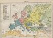
Völkerkarte von Europa
1 : 36000000 Europa Ethnische Gruppe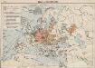
Das Deutschtum in Europa
1 : 36000000 Europa Ethnische Gruppe, Deutsche
Europae [Karte], in: Theatrum orbis terrarum, S. 52.
1 Karte aus Atlas Ortelius, Abraham Vrients, Jan Baptista
Europa zur Zeit Napoleon's I. (um 1810)
1 : 15000000 Europa Napoleon I., Frankreich, Kaiser
Europa. Bodengestalt
1 : 24000000 Europa Physische Geografie
Europe : laid down from the observations of the Royal Academy of Sciences & compared with the maps of Sanson, Nolin, Du Fer, De l'Isle, Moll & other modern geographers ... / [John Bowles] ; engrav'd by Emanuel Bowen
1 : 4500000 Annotatie: Met tabel van Europese lengtematen; Met informatie over de verschillende Europese staten Bowles, John; Bowen, Emanuel London : printed for John Bowles
Europa 1885
Europa Kunz, Andreas ; Röss, Wolf ; Moeschl, Joachim Robert
Übersichts Karte zu den Reisen in Europa, Asien und Afrika unternommen von dem k. k. oesterreich. Bergrathe Joseph Russegger in den Jahren von 1835 bis 1841
1 : 11400000 Afrika E. Schweizerbart'schen Buchhandlung
Übersichts Karte zu den Reisen in Europa, Asien und Afrika unternommen von dem k. k. oesterreich. Bergrathe Joseph Russegger in den Jahren von 1835 bis 1841
1 : 11400000 Afrika
Europa 1911
Europa Kunz, Andreas ; Röss, Wolf ; Moeschl, Joachim Robert
L'Europe, suivant les nouvelles observations de Messrs. de l'Academie Royale des Sciences, etc.
1 : 5100000 augmentées de nouveau Leyde : chez Pierre van der Aa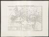
Carta generale dell'impero romano sotto Costantino
1 : 11000000 Marzolla, Benedetto [Verlag nicht ermittelbar]