Maps of Sahara

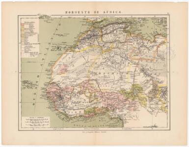
Noroeste de Africa
1 mapa. Datat al s. XIX. Gras y compañia, editores. Madrid
Mittel- und Nord-Africa, westl. Theil

Mittel- und Nord-Africa und Arabien. Westliches Blatt
Stieler's Hand-Atlas Stieler, Adolf bei Justus Perthes
Tabula Moderna Prime Partis Aphricae [Karte], in: Claudii Ptolemei viri Alexandrini mathematice discipline philosophi doctissimi geographie opus [...], S. 263.
1 Karte aus Atlas Waldseemüller, Martin [und Ptolemaeus, Claudius] Übelin, Georg
Afrique, septentrionale.
1 : 16000000 Picquet, C.
Province of Nova Scotia (Island of Cape Breton). Sheet no. 20.
1 : 63360 Geological Survey of Canada
Barbary and Bildulgerid ; A map of Zaara, Negroe-land, Guinea, &c. (Inset: The Isles of C, Verd)
from A system of geography, or, A new & accurate description of the earth in all its empires, kingdoms and states : illustrated with history and topography, and maps of every country : fairly engraven on copper, according to the latest discoveries and corrections / by Herman Moll.
Lisbon, Littleton.
1 : 4800 D.H. Hurd & Co.
Hillsborough Bridge P.O.
D.H. Hurd & Co.
Carte de la Barbarie de la Nigritie et de la Guinée / par Guill.me Del'Isle de l'Academie Royale des Sciences
1 : 9000000 Annotatie: Afkomstig uit: Atlas nouveau ... / par Guillaume de l'Isle. - Amsterdam : Jean Covens & Corneille Mortier, [na 1757]; Oorspr. afkomstig uit: Atlas de géographie / G. de l'Isle. - Paris : G. de l'Isle, [1700-1712]; Lit.: Norwich's maps of Africa / O. I. Norwich ; Pam Kolbe. - 2nd ed., p. 362, krt. 317; Africa on maps dating from the twelfth to the eighteenth century / E. Klemp, p. 30 en krt. 25; Annotatie geografische gegevens: Met 2 schaalstokken Guillaume Delisle 1675-1726 A Amsterdam : chez Jean Covens et Corneille Mortier
Scarsdale.
1 : 3600 Bromley, George Washington; Bromley, Walter Scott; G.W. Bromley & Co.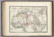
Afrique partie Nord.
1 : 16000000 Levasseur, E.
Nord Africa.
1 : 24000000 Reichard, C. G.
Itinéraires suivis par les voyages Français et autres qui ont pénétré dans le Sahara
1 : 20000000 Erhard Bros. (Firm) Imp-Janson
West Africa.
1 : 15000000 Colton, G.W.

[Mittel- und Nord-Africa und Arabien, Westliches Blatt]
Hand-Atlas über alle Theile der Erde nach dem neuesten Zustande und über das Weltgebäude Stieler, Adolf bei Justus Perthes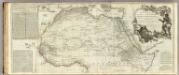
Africa, with all its states, kingdoms, republics, regions, islands, &ca. (northern section)
1 : 8400000 Boulton, S.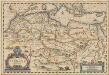
Nova Barbariae Descriptio. [Karte], in: Novus atlas absolutissimus, Bd. 6, S. 162.
1 Karte aus Atlas Janssonius Offizin
North Western {LF}{LF}Africa
1 : 15000000 Colton, G.W.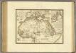
Afrique, septentrionale.
1 : 15000000 Brue, Adrien Hubert, 1786-1832
Carte détaillée (en deux feuilles) de l'Afrique et des îles qui en dépendent (partie septentrionale)
1 : 16323500 par A. Brué, d'après les observations astronomiques, les découvertes et les hypothèses les plus récentes Paris : chez l'auteur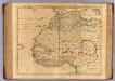
Barbarie, Nigritie, Guinee.
1 : 9200000 L'Isle, Guillaume de, 1675-1726
Barbarie, Nigritie, Guinee.
1 : 9200000 L'Isle, Guillaume de, 1675-1726
Carte de la Barbarie de la Nigritie et de la Guinée
1 : 9000000
Africa Antiqua.
1 : 58000000 Fenner, Rest.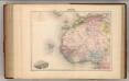
Afrique (Partie Nord-Ouest).
1 : 14400000 Migeon, J.
Mittel- & Nord-Afrika, Westl. Theil
Handatlas über alle Theile der Erde und über das Weltgebäude Stieler, Adolf Justus Perthes
North Western Africa.
1 : 15000000 Colton, G.W.