Maps of Castilla y León
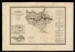
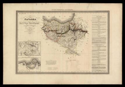
Navarra y provincias vascongadas con las nuevas divisiones
1 Mapa. Atlas Nacional de España Dufour, A.H. 0
Le royaume de France, 4
1 Blatt : 47 x 45 cm Jaillot
Legionis, Biscaiae Et Guipiscoae Typus [Karte], in: Gerardi Mercatoris Atlas, sive, Cosmographicae meditationes de fabrica mundi et fabricati figura, S. 180.
1 Karte aus Atlas Mercator, Gerhard Montanus, Petrus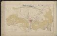
Legionis Biscaiae Et Guipiscoae Typus [Karte], in: Gerardi Mercatoris et I. Hondii Newer Atlas, oder, Grosses Weltbuch, Bd. 2, S. 183.
1 Karte aus Atlas Mercator, Gerhard und Hondius, Jodocus Jansson, Jan
Regnorum Castellæ veteris Legionis et Gallæciæ principatuumque Biscaiæ et Asturiarum accuratissima descriptio, 2
1 Blatt : 48 x 41 cm Visscher
Castilla la Vieja con las nuevas divisiones
1 Mapa. Atlas Nacional de España Dufour, A.H. 0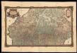
Carte generale des Monts Pyrénees, et partie des royaumes de France et d'Espagne / par le Sr. Roussel ; J.B. Delahaye scrip. ; A. Coquart fecit
1 : 270000 1 Mapa, col. Datació aproximada. Roussel ; Delahaye, J.B. ; Coquart, A. Dépôt des Fortifications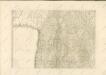

Spain. Espana II.
1 : 1800000 Society for the Diffusion of Useful Knowledge (Great Britain)
Neueste Generalkarte von Portugal und Spanien, 2
1 Blatt : 71 x 50 cm Schrämbl
Regna Hispaniarum, atque Portugalliæ, 2
1 Blatt : 53 x 63 cm Gerard Valck
Exactissima et plane nova tabula, in qua summa cura delineata invetus Arragoniae regissima et Navarrae, una cum Cataloniae principatu
1 : 1100000 per Jacobum Robyn Luggerdus van Anse schulp. Amsterdam : [s.n.]
Theatre de la guerre en Espagne [et]c
1 Blatt : 51 x 64 cm Covens et Mortier
A new Military Map of Spain and Portugal compiled from The Nautical Surveys of Don Vincent Tofiño, the new Provincial maps of Don Tomas Lopez, the large map of the Ptrenees by Roussill, and various original documents
1 Mapa en 4 seccions dins d'un estoig. John Stockdale J. Stockdale
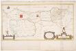
Arragonia et Catalonia [Karte], in: Gerardi Mercatoris Atlas, sive, Cosmographicae meditationes de fabrica mundi et fabricati figura, S. 192.
1 Karte aus Atlas Mercator, Gerhard Montanus, Petrus
[Carte d'Espagne et de Portugal en neuf feuilles, 2]
1 Blatt : 31 x 41 cm P.G. Chanlaire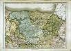
Espagne et Portugal, 2
1 Blatt : 31 x 42 cm Mentelle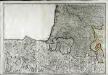
Neueste Generalkarte von Frankreich, 5
1 Blatt : 54 x 78 cm F.A. Schrämbl
Il regno di Castiglia vecchia
1 Karte : Kupferdruck ; 42 x 54 cm Cantelli da Vignola; Rossi; Barbey Domenico de Rossi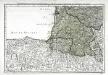
Cinquieme feuille contenant la Guienne, le Bearn, la Basse Navarre, le comté de Foix, et une partie du Languedoc
1 Blatt : 38 x 54 cm Bourgoin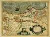
Legionis, Biscaiæ et Guipiscoæ typus
1 Karte : Kupferdruck ; 33 x 46 cm Mercator; Hondius Henricus Hondius
Legionis, Biscaiae et Guipiscoae typus
1 Karte : Kupferdruck ; 17 x 24 cm Mercator Cloppenburgh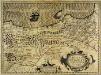
Legionis, Biscaiæ et Guipiscoæ typus
1 Karte : Kupferdruck ; 33 x 46 cm Mercator; Hondius Jodocus Hondius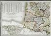
Carte de la république de France, no. 5
1 Blatt : 42 x 59 cm s.n.
Aragonia et Navarra
1 Karte : Kupferdruck ; 37 x 48 cm s.n.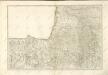
Principato Asturias, Biscaia et Guispus, Alava / [J.F. van Essen]
1 : 700000 Annotatie: De kaart is vermoedelijk vervaardigd door J.F. van Essen uit Antwerpen; Gerestaureerd, 1995; Met opgeplakte cartouches Essen, J. F. van [S.l. : s.n.]
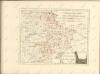
Castilla La Vieja con las nuevas divisiones
1 : 600000 formada por A. H. Dufour Paris : Bulla