Maps of Spain

Mapa de España y Portugal: dividido en sus actuales provincias y orlado con los de las posesiones ultramarinas españolas y los planos de las principales ciudades
1 : 800000 . Conté 3 mapes: Islas Canarias, Islas Antillas, Islas Filipinas; i 8 plantes de ciutats: S. Sebastián, Sevilla, La Habana, Madrid, Palma, Zaragoza, Valencia, Barcelona. - Fotografia: T-VI-1-17698 Martín de López, Pedro; Alabern, Ramon Gaspar y Roig
Secunda Europe Tabula [Karte], in: [Clavdii Ptholomei Cosmographi ...], S. 248.
1 Karte aus Atlas Nicolaus Germanus [und Ptolemaeus, Claudius]
Spanien und Portugal
Schul-Atlas über alle Theile der Erde nach dem neuesten Zustande, und über das Weltgebäude Stieler, Adolf Justus Perthes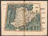
Tabula Secunda Europe [Hispania] [Karte], in: Claudii Ptolemei viri Alexandrini mathematice discipline philosophi doctissimi geographie opus [...], S. 154.
1 Karte aus Atlas Waldseemüller, Martin [und Ptolemaeus, Claudius] Übelin, Georg
Spanien und Portugal
E. von Sydow's Schul-Atlas in sechs und dreissig Karten Sydow, Emil von bei Justus Perthes
Tabula Europae II. [Karte], in: Geographia universalis vetus et nova complectens Claudii Ptolemaei Alexandrini enarrationis libros VIII, S. 225.
1 Karte aus Atlas Münster, Sebastian [und Ptolemaeus, Claudius]
Tabula Moderna Et Nova Hispanie [Karte], in: Claudii Ptolemei viri Alexandrini mathematice discipline philosophi doctissimi geographie opus [...], S. 239.
1 Karte aus Atlas Waldseemüller, Martin [und Ptolemaeus, Claudius] Übelin, Georg
Carte générale de l'Espagne et du Portugal / par A.H. Brué
1 Mapa. Atlas universel; 22 Brué. Adrien-Hubert chez l'auteur et chez Simonneau
Regnorum Hispaniae nova descriptio
1 mapa, col.. Text: francès. Reclam: A, 1. - Originàriament dins: Le Theatre du monde ou novvel atlas, mis en lumiere par Gvillavme & Iean Blaeu. Amsterdam, 1643. Blaeu, Willem Jansz.; Blaeu, Joan mis en lumiere par Gvillavme & Iean Blaeu
Mare Mediterraneum, 1
1 Blatt : 47 x 58 cm G. und L. Valck
France.
from A new systeme of the mathematicks: containing I. Arithmetick, as well natural and decimal, as in species, or the principles of algebra. II. Practical geometry, together with the first six books of Euclid's Elements, as also the eleventh and twelfth, symbo
[Spanien und Portugal, Iberische Halbinsel]
Geographischer Atlas über alle Theile der Erde Ziegler, Jakob Melchior Verlag von Dietrich Reimer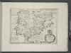
Spain and Portugal.
from A new sett of maps both of antient and present geography : wherein not only the latitude and longitude of many places are corrected according to the latest observations, but also the most remarkable differences of antient and present geography may be quickly discern'd by a bare inspection or comparing of correspondent maps, which seems to be the most natural and easy method to lead young students (for whose use the work is principally intended) unto a competent knowledge of the geographical science : together with a geographical treatise particularly adapted to the use and design of these maps / by Edward Wells, M.A. and student of Christ-Church, Oxon.
Map of France, Spain, and Portugal; Switzerland in cantons [inset]; Island of Corsica [inset].
from Mitchell's new general atlas, containing maps of the various countries of the world, plans of cities, etc., embraced in fifty-three quarto maps., forming a series of eighty four maps and plans, together with valuable statistical tables.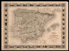
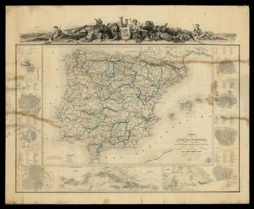
Carte administrative, physique et routiere de l'Espagne et du Portugal indiquant les canaux, les rivieres naviables, les routes de poste et les nouvelles divisions des provinces, &c.
1 Mapa, col. Orla amb 32 vistes de ciutats i monuments. - Limits acolorits Dufour, A.-H. Dufour, Bulla et Jouy
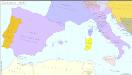
Südeuropa 1861
Südeuropa Kunz, Andreas ; Röss, Wolf ; Johnen, Bettina ; Moeschl, Joachim Robert
Südeuropa 1881
Südeuropa Kunz, Andreas ; Röss, Wolf ; Johnen, Bettina ; Moeschl, Joachim Robert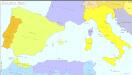
Südeuropa 1929
Südeuropa Kunz, Andreas ; Treiling, Thomas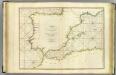
Coasts Spain, Portugal, Barbary.
1 : 3200000 Faden, William, 1750?-1836
Südeuropa 1947
Südeuropa Kunz, Andreas ; Treiling, Thomas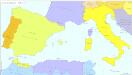
Südeuropa 1922
Südeuropa Kunz, Andreas ; Treiling, Thomas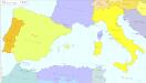
Südeuropa 1956
Südeuropa Kunz, Andreas ; Treiling, Thomas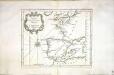
Carte des costes de France et d'Espagne
1 Karte : Kupferdruck ; 21 x 26 cm Bellin Arkstée et Merkus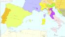
Südeuropa 1789
Südeuropa Kunz, Andreas ; Treiling, Thomas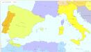
Südeuropa 1954
Südeuropa Kunz, Andreas ; Treiling, Thomas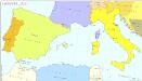
Südeuropa 1870
Südeuropa Kunz, Andreas ; Röss, Wolf ; Johnen, Bettina ; Moeschl, Joachim Robert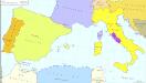
Südeuropa 1866
Südeuropa Kunz, Andreas ; Röss, Wolf ; Johnen, Bettina ; Moeschl, Joachim Robert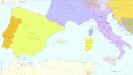
Südeuropa 1806
Südeuropa Kunz, Andreas ; Treiling, Thomas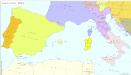
Südeuropa 1805
Südeuropa Kunz, Andreas ; Treiling, Thomas