Maps of Hranice
II. vojenské mapování 10
1 : 144000
Special - Karte der Markgrafschaft Maehren und des Herzogthums Schlesien
II. vojenské mapování 10
1 : 144000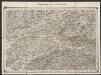
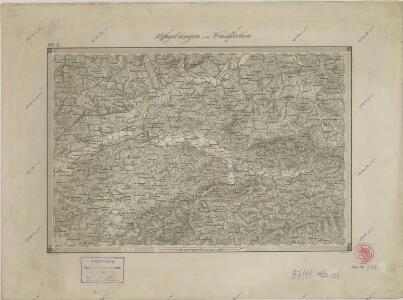
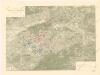
Umgebungen von Weiskirchen
1 : 144000 K.K. Militärisches Geographisches Institut
Podrobná místopisná mapa Království Českého

Podrobná místopisná mapa Království Českého

Podrobná mapa Markrabství moravského a Vévodství slezkého
1 : 100000 Hranice (Přerov, Česko : oblast) Srp, Jan Jos. R. Vilímek
Hranice a okolí
Soubor vojenských map 1900 - 1910

Hranice a okolí
1 : 75000 Hranice (Přerov, Česko : oblast) Vojenský zeměpisný ústav
Mapa hejtmanství Hranického

Příruční mapa okresu Nový Jičín

Neutitschein
1 : 75000 Frenštát pod Radhoštěm (Česko : oblast) Fitz K. u. k. Militärgeographisches Institut
Nový Jičín
1 : 75000 Hustopeče nad Bečvou (Česko : oblast) Vojenský zeměpisný ústav
III. vojenské mapování 4160
1 : 75000
Karte des Gemeindegrenzen

Vsetín
1 : 75000 Morava (Česko) Vojenský zeměpisný ústav
Vsetín
1 : 75000 Morava (Česko) Vojenský zeměpisný ústav
III. vojenské mapování 4260
1 : 75000
Wal. Meseritsch.; Spezialkarte der osterreichisch-ungarischen Monarchie.
from Spezialkarte der osterreichisch-ungarischen Monarchie. Austro-Hungarian Monarchy. Militärgeographisches Institut.,
Vsetín a Val. Meziříčí
1 : 75000 Morava (Česko) Vojenský zeměpisný ústav


[Kartenblatt]
1 : 25000 Hranice (Přerov, Česko : oblast) Reichsamt für Landesaufnahme

[Kartenblatt]
1 : 25000 Hustopeče nad Bečvou (Česko : oblast) Reichsamt für Landesaufnahme
III. vojenské mapování 4159/4
1 : 25000
Gradkartenblatt
1 : 25000 Bystřice pod Hostýnem-oblast (Česko) Catinelli, Max von
Gradkartenblatt
1 : 25000 Hranice-oblast (Přerov, Česko) Genecke, Hugo