Maps of Benešov nad Černou
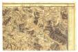
II. vojenské mapování 35
1 : 144000
Podrobné mapy zemí Koruny české v měřítku 1:75.000 a mapy vzdáleností všech míst při silnici ležících
1 : 75000 Trhové Sviny (Česko : oblast) Bělohlav, Josef F. Topič
Podrobné mapy zemí Koruny české v měřítku 1:75.000 a mapa vzdáleností všech míst při silnici ležících - České Budějovice - Trhové Sviny. Průvodce statisticko-historický po všech místech na těchto mapách uvedených a rejstřík věcný názvů hor, potoků, řek, rybníků atd. Sešit 33. List 61,
1 : 75000
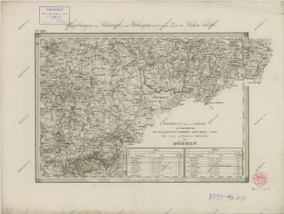
Gradkartenblatt
1 : 25000 Borovany-oblast (České Budějovice, Česko) Gerstner, Eduard von

[Mapový list]
1 : 25000 Nové Hrady-oblast (České Budějovice, Česko) Vojenský zeměpisný ústav
III. vojenské mapování 4453/4
1 : 25000
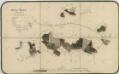
Přehledná mapa polesí Ledenice 1

Generální mapa panství Třeboň a inkorporovaných statků Bzí, Lomnice, Borovany, Třeboň, Hamr a Val 1
Přehledná mapa polesí Ledenice 1

Generální mapa panství Třeboň a inkorporovaných statků Bzí, Lomnice, Borovany, Třeboň, Hamr a Val 1

Situační plán erární silnice od dvora Kuna do Ledenic 1
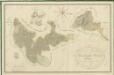
Přehledná mapa polesí Ledenice 1
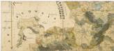
Administrativní mapa třeboňského panství se statky Bzí,Lomnice, Borovany,Hamr a Val 1

[Mapový list]
1 : 25000 Borovany-oblast (České Budějovice, Česko) Vojenský zeměpisný ústav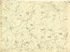
III. vojenské mapování 4453/2
1 : 25000
Porostní mapa polesí Borovany 1
Porostní mapa polesí Zborov 1

Porostní mapa polesí Ledenice 1
1 : 15000
Beneschau - c0113-2-009 - Kaiserpflichtexemplar der Landkarten des stabilen Katasters
1 : 2880
Beneschau - c0113-2-005 - Kaiserpflichtexemplar der Landkarten des stabilen Katasters
1 : 2880
Beneschau - c0113-2-001 - Kaiserpflichtexemplar der Landkarten des stabilen Katasters
1 : 2880
Beneschau - c0113-2-008 - Kaiserpflichtexemplar der Landkarten des stabilen Katasters
1 : 2880
Beneschau - c0113-2-014 - Kaiserpflichtexemplar der Landkarten des stabilen Katasters
1 : 2880
Beneschau - c0113-2-004 - Kaiserpflichtexemplar der Landkarten des stabilen Katasters
1 : 2880
Beneschau - c0113-2-011 - Kaiserpflichtexemplar der Landkarten des stabilen Katasters
1 : 2880
Beneschau - c0113-2-013 - Kaiserpflichtexemplar der Landkarten des stabilen Katasters
1 : 2880
Beneschau - c0113-2-006 - Kaiserpflichtexemplar der Landkarten des stabilen Katasters
1 : 2880
Beneschau - c0113-2-015 - Kaiserpflichtexemplar der Landkarten des stabilen Katasters
1 : 2880
Beneschau - c0113-2-010 - Kaiserpflichtexemplar der Landkarten des stabilen Katasters
1 : 2880
Beneschau - c0113-2-007 - Kaiserpflichtexemplar der Landkarten des stabilen Katasters
1 : 2880
Beneschau - c0113-2-003 - Kaiserpflichtexemplar der Landkarten des stabilen Katasters
1 : 2880
Beneschau - c0113-2-002 - Kaiserpflichtexemplar der Landkarten des stabilen Katasters
1 : 2880