Maps of Šaštín-Stráže
III. vojenské mapování 4558/2
1 : 25000
[Kartenblatt]
1 : 25000 Slovensko Reichsamt für Landesaufnahme
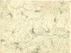
Landshut, Schlossberg und Hohenau
1 : 75000 Lanžhot, Hohenau an der March Schrift u. Gerippe v. Hptm. Schuberth. Terrainschraffirung v. R. Bloschitz

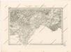
III. vojenské mapování 4558
1 : 75000
Lanžhot a Šaštín
1 : 75000 Lanžhot (Česko : oblast) Vojenský zeměpisný ústav
Lanžhot
1 : 75000 Lanžhot-oblast (Česko) Vojenský zeměpisný ústav
Lanžhot a Šaštín
1 : 75000 Lanžhot (Česko : oblast) Vojenský zeměpisný ústav
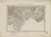
III. vojenské mapování 4558
1 : 75000
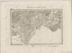
Landshut, Sasvar und Hohenau.
from Spezialkarte der osterreichisch-ungarischen Monarchie.
Generální mapa okresních hejtmanství
II. vojenské mapování 18
1 : 144000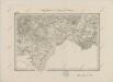
II. vojenské mapování 18
1 : 144000
Malé Karpaty severná časť
Special - Karte der Markgrafschaft Maehren und des Herzogthums Schlesien
II. vojenské mapování 18
1 : 144000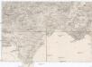
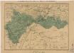
Umgebungen von Gaya und Göding
1 : 144000 Hodonín (Česko : oblast) K.K. Militärisch-Geographisches Institut
Goding und Lundenburg.
from Spezialkarte der osterreichisch-ungarischen Monarchie.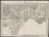
Umgebungen von Gaya und Göding
1 : 144000 K.K. Militärisches Geographisches Institut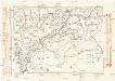
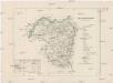
Komunikační mapa země Moravskoslezské
1 : 100000 Hodonín (Česko : oblast) Morslez. zem. výbor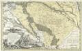
Comitatvs Posoniensis Germanis Presbvrg dicti Delineatio Geographica
1 : 150000 Mollova mapová sbírka Homann, Johann Baptist Alber, Johann Eberhard Homann, Johann Baptista - dědici
C. Nitriensis. Tab. II
Slowakei Komitat Neutra
Bratislava okolie
Ober-Neutraer Comitat
1 : 280000 Nitra-oblast (Slovensko)
Carte Topographique d'Allemagne.
1 : 220000 Mollova mapová sbírka Jaeger, Johann Wilhelm Abraham Berndt, Johann Christoph Jäger, Johann Wilhelm Abraham
Národnostní mapa Moravy
1 : 150000 Morava jižní (Česko) Chytil, Alois nákladem Al. Chytila
Národnostní mapa Moravy

Generalkarte 1:200 000 zum Kriegsspielplan von Poisdorf
1 : 200000 Poysdorf (Rakousko) K.u.k militär-geographisches Institut


