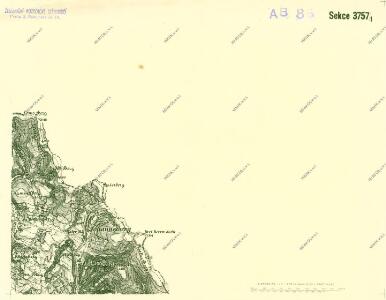
Maps of Heřmánkovice

III. vojenské mapování 3757/1
1 : 25000
[Gradkartenblatt]
1 : 25000 Čechy (Česko) Vojenský zeměpisný ústav
Hermsdorf (Hermankowice) - c1836-1-004 - Kaiserpflichtexemplar der Landkarten des stabilen Katasters
1 : 2880
Hermsdorf (Hermankowice) - c1836-1-010 - Kaiserpflichtexemplar der Landkarten des stabilen Katasters
1 : 2880
Hermsdorf (Hermankowice) - c1836-1-009 - Kaiserpflichtexemplar der Landkarten des stabilen Katasters
1 : 2880
Hermsdorf (Hermankowice) - c1836-1-005 - Kaiserpflichtexemplar der Landkarten des stabilen Katasters
1 : 2880
Hermsdorf (Hermankowice) - c1836-1-006 - Kaiserpflichtexemplar der Landkarten des stabilen Katasters
1 : 2880
Hermsdorf (Hermankowice) - c1836-1-007 - Kaiserpflichtexemplar der Landkarten des stabilen Katasters
1 : 2880
Hermsdorf (Hermankowice) - c1836-1-002 - Kaiserpflichtexemplar der Landkarten des stabilen Katasters
1 : 2880
Hermsdorf (Hermankowice) - c1836-1-008 - Kaiserpflichtexemplar der Landkarten des stabilen Katasters
1 : 2880
Hermsdorf (Hermankowice) - c1836-1-003 - Kaiserpflichtexemplar der Landkarten des stabilen Katasters
1 : 2880
Hermsdorf (Hermankowice) - c1836-1-001 - Kaiserpflichtexemplar der Landkarten des stabilen Katasters
1 : 2880
Meßtischblatt 5364 : Wüstegiersdorf, 1937
1 : 250000 Wüstegiersdorf. - Aufn. 1930, hrsg. 1934, einz. Nachtr. 1937. - 1:25000. - [Berlin]: Reichsamt für Landesaufnahme, 1937. - 1 Kt.

[Kartenblatt]
1 : 25000 Broumov (Náchod, Česko : oblast) Reichsamt für Landesaufnahme
Rosenthal (Ružkow) - c6602-1-003 - Kaiserpflichtexemplar der Landkarten des stabilen Katasters
1 : 2880
Rosenthal (Ružkow) - c6602-1-001 - Kaiserpflichtexemplar der Landkarten des stabilen Katasters
1 : 2880
Rosenthal (Ružkow) - c6602-1-002 - Kaiserpflichtexemplar der Landkarten des stabilen Katasters
1 : 2880
Rosenthal (Ružkow) - c6602-1-004 - Kaiserpflichtexemplar der Landkarten des stabilen Katasters
1 : 2880
Vilímkovy místopisné mapy zemí Koruny české
1 : 100000 Broumov (Náchod, Česko : oblast) Srp, Jan Jos. R. Vilímek
Topographische und Militairische Carte desienigen Theils von Boehmen...

Karte der Bezirkshauptmannschaft Braunau
1 : 75000 Broumov-oblast (Náchod, Česko) Stelzig, Heinrich Heinrich Stelzig
Podrobná mapa Království českého
1 : 100000 Broumov (Náchod, Česko : oblast) Srp, Jan Jaroslav Bursík
Schönau bei Bhm. Braunau
1 : 75000 Broumov (Náchod, Česko : oblast) Bloschitz, R. K. u. k. Militärgeographisches Institut
Schönau bei B[ö]hm[isch] Branau
1 : 75000 Čechy (Česko) K. u. k. Militärgeographisches Institut
Karte der Bezirkshauptmannschaft Braunau
1 : 100000 Broumov-oblast (Náchod, Česko) Erben, Josef Karl Janský
Mapa okresního hejtmanství Broumovského

Mapa okresního hejtmanství Broumovského
Podrobná místopisná mapa Království Českého