Maps of Hollabrunn

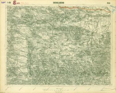
III. vojenské mapování 4556
1 : 75000
III. vojenské mapování 4556
1 : 75000
Hollabrunn
1 : 75000 Rakousko Vojenský zeměpisný ústav
[Gradkartenblatt]
1 : 25000 Morava (Česko)
III. vojenské mapování 4556/1
1 : 25000
III. vojenské mapování 4556/2
1 : 25000
[Gradkartenblatt]
1 : 25000 Dolní Rakousko (Rakousko) Kartographisches Institut
[Gradkartenblatt]
1 : 25000 Jaroslavice-oblast (Znojmo, Česko)
Šengrabenskīj boj 4-go nojabrja 1805 g.
Österreich Hollabrunn Napoleonische Kriege
Ober Hallabrunn.
from Spezialkarte der osterreichisch-ungarischen Monarchie.

Joslowitz - m1044-1-006 - Kaiserpflichtexemplar der Landkarten des stabilen Katasters
1 : 2880
Joslowitz - m1044-1-014 - Kaiserpflichtexemplar der Landkarten des stabilen Katasters
1 : 2880
Joslowitz - m1044-1-002 - Kaiserpflichtexemplar der Landkarten des stabilen Katasters
1 : 2880
Joslowitz - m1044-1-013 - Kaiserpflichtexemplar der Landkarten des stabilen Katasters
1 : 2880
Joslowitz - m1044-1-001 - Kaiserpflichtexemplar der Landkarten des stabilen Katasters
1 : 2880
Joslowitz - m1044-1-010 - Kaiserpflichtexemplar der Landkarten des stabilen Katasters
1 : 2880
Joslowitz - m1044-1-008 - Kaiserpflichtexemplar der Landkarten des stabilen Katasters
1 : 2880
Joslowitz - m1044-1-009 - Kaiserpflichtexemplar der Landkarten des stabilen Katasters
1 : 2880
Joslowitz - m1044-1-004 - Kaiserpflichtexemplar der Landkarten des stabilen Katasters
1 : 2880
Joslowitz - m1044-1-011 - Kaiserpflichtexemplar der Landkarten des stabilen Katasters
1 : 2880
Joslowitz - m1044-1-012 - Kaiserpflichtexemplar der Landkarten des stabilen Katasters
1 : 2880
Joslowitz - m1044-1-005 - Kaiserpflichtexemplar der Landkarten des stabilen Katasters
1 : 2880
Joslowitz - m1044-1-003 - Kaiserpflichtexemplar der Landkarten des stabilen Katasters
1 : 2880
Joslowitz - m1044-1-007 - Kaiserpflichtexemplar der Landkarten des stabilen Katasters
1 : 2880
Localstrecke von Wien K. F. J. B. bis Krems mit Umgebung
Kremže (Rakousko) K. k. Österreichische Staatsbahnen
Das in dem Ertzhertzogtumb Vnter Osterreich
1 : 246000 Dolní Rakousko (Rakousko) Vischer, Georg Matthaeus Hoffmann, Jakob
Generální mapa Protektorátu Čechy a Morava

Generalkarte 1:200 000 zum Kriegsspielplan von Poisdorf
1 : 200000 Poysdorf (Rakousko) K.u.k militär-geographisches Institut