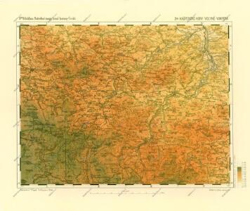
Maps of Vimperk

Podrobné mapy zemí Koruny české v měřítku 1:75.000 a mapa vzdáleností všech míst při silnici ležících. Volyně - Vimperk. Průvodce statisticko-historický po všech místech na těchto mapách uvedených a rejstřík věcný názvů hor, potoků, řek, rybníků atd. Sešit 31. List 34,
1 : 75000
Sušice
1 : 75000 Sušice-oblast (Klatovy, Česko) Vojenský zeměpisný ústav
Sušice a Vimperk
1 : 75000 Sušice (Klatovy, Česko : oblast) Vojenský zeměpisný ústav

Gradkartenblatt
1 : 25000 Vimperk-oblast (Česko) Gerstner, Eduard von
III. vojenské mapování 4351/4
1 : 25000
[Mapový list]
1 : 25000 Vimperk-oblast (Česko) Vojenský zeměpisný ústav

[Kartenblatt]
1 : 25000 Borová Lada (Česko) Reichsamt für Landesaufnahme
Kaltenbach - c5273-1-014 - Kaiserpflichtexemplar der Landkarten des stabilen Katasters
1 : 2880
Kaltenbach - c5273-1-002 - Kaiserpflichtexemplar der Landkarten des stabilen Katasters
1 : 2880
Kaltenbach - c5273-1-007 - Kaiserpflichtexemplar der Landkarten des stabilen Katasters
1 : 2880
Kaltenbach - c5273-1-008 - Kaiserpflichtexemplar der Landkarten des stabilen Katasters
1 : 2880
Kaltenbach - c5273-1-018 - Kaiserpflichtexemplar der Landkarten des stabilen Katasters
1 : 2880
Kaltenbach - c5273-1-013 - Kaiserpflichtexemplar der Landkarten des stabilen Katasters
1 : 2880
Kaltenbach - c5273-1-003 - Kaiserpflichtexemplar der Landkarten des stabilen Katasters
1 : 2880
Kaltenbach - c5273-1-001 - Kaiserpflichtexemplar der Landkarten des stabilen Katasters
1 : 2880
Kaltenbach - c5273-1-012 - Kaiserpflichtexemplar der Landkarten des stabilen Katasters
1 : 2880
Kaltenbach - c5273-1-015 - Kaiserpflichtexemplar der Landkarten des stabilen Katasters
1 : 2880
Kaltenbach - c5273-1-009 - Kaiserpflichtexemplar der Landkarten des stabilen Katasters
1 : 2880
Kaltenbach - c5273-1-005 - Kaiserpflichtexemplar der Landkarten des stabilen Katasters
1 : 2880
Kaltenbach - c5273-1-011 - Kaiserpflichtexemplar der Landkarten des stabilen Katasters
1 : 2880
Kaltenbach - c5273-1-016 - Kaiserpflichtexemplar der Landkarten des stabilen Katasters
1 : 2880
Kaltenbach - c5273-1-010 - Kaiserpflichtexemplar der Landkarten des stabilen Katasters
1 : 2880
Kaltenbach - c5273-1-006 - Kaiserpflichtexemplar der Landkarten des stabilen Katasters
1 : 2880
Kaltenbach - c5273-1-004 - Kaiserpflichtexemplar der Landkarten des stabilen Katasters
1 : 2880
Kaltenbach - c5273-1-017 - Kaiserpflichtexemplar der Landkarten des stabilen Katasters
1 : 2880
Gradkartenblatt
1 : 25000 Kašperské Hory-oblast (Česko) Gerstner, Eduard von
[Gradkartenblatt]
1 : 25000 Soběšice-oblast (Klatovy, Česko) Vojenský zeměpisný ústav