Maps of Klatovy

Podrobné mapy zemí Koruny české v měřítku 1:75.000 a mapa vzdáleností všech míst při silnici ležících - Klatovy - Nýrsko - Sušice. Průvodce statisticko-historický po všech místech na těchto mapách uvedených a rejstřík věcný názvů hor, potoků, řek, rybníků atd. Sešit 32. List 23,
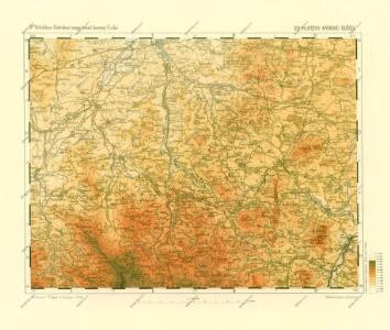
1 : 75000
Podrobné mapy zemí Koruny české v měřítku 1:75.000 a mapy vzdáleností všech míst při silnici ležících
1 : 75000 Klatovy (Česko : oblast) Bělohlav, Josef F. Topič
Porostní mapa revíru Týnec
1 : 25000
Gradkartenblatt
1 : 25000 Nalžovské Hory-oblast (Česko) Albrecht, Julius
III. vojenské mapování 4251/3
1 : 25000
III. vojenské mapování 4251/3
1 : 25000
Gradkartenblatt
1 : 25000 Nýrsko-oblast (Česko) Bulla, Eduard
III. vojenské mapování 4250/4
1 : 25000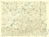
III. vojenské mapování 4250/4
1 : 25000
III. vojenské mapování 4250/4
1 : 25000
[Kartenblatt]
1 : 25000 Janovice nad Úhlavou (Česko : oblast) Reichsamt für Landesaufnahme

Hospodářská mapa revíru Běšiny
1 : 2880
Katastrální mapa obce Horní Lhota
1 : 2880
Hospodářská mapa revíru Srbice
1 : 2880
Hospodářská a porostní mapa revíru Dlažov, Miletice, Běhařov
1 : 20000
Porostní mapa revíru Těšetiny
1 : 5000
Porostní mapa revíru Běšiny
1 : 5000
Kolinetz (Kolinec) - c3284-1-001 - Kaiserpflichtexemplar der Landkarten des stabilen Katasters
1 : 2880
Kolinetz (Kolinec) - c3284-1-005 - Kaiserpflichtexemplar der Landkarten des stabilen Katasters
1 : 2880
Kolinetz (Kolinec) - c3284-1-003 - Kaiserpflichtexemplar der Landkarten des stabilen Katasters
1 : 2880
Kolinetz (Kolinec) - c3284-1-004 - Kaiserpflichtexemplar der Landkarten des stabilen Katasters
1 : 2880
Kolinetz (Kolinec) - c3284-1-002 - Kaiserpflichtexemplar der Landkarten des stabilen Katasters
1 : 2880
Janowitz (Janowice) - c2763-1-004 - Kaiserpflichtexemplar der Landkarten des stabilen Katasters
1 : 2880
Janowitz (Janowice) - c2763-1-005 - Kaiserpflichtexemplar der Landkarten des stabilen Katasters
1 : 2880
Janowitz (Janowice) - c2763-1-001 - Kaiserpflichtexemplar der Landkarten des stabilen Katasters
1 : 2880
Janowitz (Janowice) - c2763-1-002 - Kaiserpflichtexemplar der Landkarten des stabilen Katasters
1 : 2880
Janowitz (Janowice) - c2763-1-003 - Kaiserpflichtexemplar der Landkarten des stabilen Katasters
1 : 2880
Porostní mapa revíru Běšiny
1 : 5000