Maps of Maine

Railway map of the New England states : prepared expressly for the Pathfinder railway guide
Snow, George K., 1826 or 7-1885 Geo. K. Snow ; Rand, Avery, & Co.
Nova Anglia Septentrionali Americae implantata Anglorumque coloniis florentissima geographicè exhibita

Railway map of routes to the White Mountains
Boardman, Harvey J.H. Bufford's Lith.
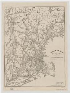
Map showing the Portland & Rochester railroad and its connections
1 : 900000 G.W. & C.B. Colton & Co G.W. & C.B. Colton & Co.
Map of railways in the New England states : engraved expressly for Snow's pathfinder railway guide
Geo. K. Snow & Hapgood (Firm) Geo. K. Snow & Hapgood

Shell Sectional Map No. 1 - New England States.
1 : 1457280 Shell Oil Company
Northern provinces of the United States
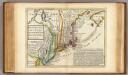
New England, New York, New Jersey and Pensilvania.
1 : 3700000 Moll, Herman, d. 1732
Lloyd's Railroad, Telegraph & Express Map of the Eastern States
Lloyd's Railroad, Telegraph & Express Map of the Eastern States to accompany Lloyd's Railroad, Telegraph & Express Map of the United States and Canadas. This map shows the communication lines of the eastern states of the Union as they existed in 1863. Reliable communication networks were vital during the war to send troops and messages from one theatre of conflict to another. The map also lists the position of telegraph stations close to the offices of Express companies which provided the main form of travel in this period of American history.
Nova Belgica Et Anglia Nova [Karte], in: Le théâtre du monde, ou, Nouvel atlas contenant les chartes et descriptions de tous les païs de la terre, Bd. 2, S. 303.
1 Karte aus Atlas Blaeu, Willem Janszoon und Blaeu, Joan Blaeu, Willem Janszoon
Carte du théatre de la guerre entre les Anglais et les Américains
1 : 1400000 Nová Anglie Brion de la Tour, Louis Esnauts et Rapilly
Nova Belgica Et Anglia Nova [Karte], in: Novus Atlas, das ist, Weltbeschreibung, Bd. 2, S. 306.
1 Karte aus Atlas Blaeu, Joan Blaeu, Willem Janszoon
Map of New England with adjacent portions of New York & Canada
1 : 1537500 Walling, Henry Francis Walling, Henry Francis
Nova Anglia Septentrionali Americae implantata Anglorumque coloniis florentissima / geographice exhibita â Ioh. Baptista Homann, sac. caes. maj. geographo.
from John H. Levine Collection John Baptista Homann, S.,
Scene of Operations of the Northern Army.
1 : 1950000 Marshall, John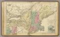
N.E. United States.
1 : 2150000 Cornell, S. S. (Sarah S.)
New England.
1 : 1550000 Walling, H. F.
New England.
1 : 2100000 Mitchell, Samuel Augustus
Map of Maine, New Hampshire, and Vermont : compiled from the latest authorities
1 : 1001000 Young, J. H. (James Hamilton) S. Augustus Mitchell
Railroad map of New England & eastern New York : compiled from the most authentic sources
1 : 700000 Goldthwait, J. H Redding & Co. ; Clark, Austin & Co.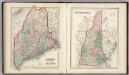
Maine. New Hampshire.
1 : 1250000 Gray, Ormando Willis
New England and New York.
1 : 3000000 Lloyd, H.H.
New England and New York.
1 : 3000000 Walling, H. F.
New England.
1 : 2700000 Cornell, S. S. (Sarah S.)
New England.
1 : 3600000 Grigg, John
G. Woolworth Colton's railroad, township & distance map of New England with adjacent portions of New York, Canada & New Brunswick
1 : 900000 Colton, G. Woolworth Colton, G. Woolworth
New Engelland, New York, New Yersey und Pensilvania

A new and accurate map of New Jersey, Pensilvania, New York and New England: with the adjacent countries / drawn from surveys, assisted by the most approved modern maps & charts and regulated by astronomical observations by Eman. Bowen.
from Charts and maps Emannuel Bowen,