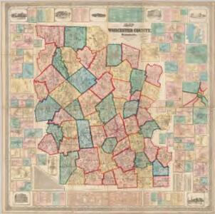
Maps of Worcester County

Map of Worcester County, Massachusetts : based upon the trigonometrical survey of the state
1 : 63360 Walling, Henry Francis, 1825-1888 Wm. E. Baker & Co.
Worcester County.
1 : 158400 Gray, Ormando Willis; Walling, H. F.
Quinsigamond
1 : 125000
Quinsigamond
1 : 125000
Quinsigamond
1 : 125000
Quinsigamond
1 : 125000
Map of Middlesex County, Massachusetts : based upon the trigonometrical survey of the state
1 : 50000 Walling, Henry Francis, 1825-1888 Smith & Bumstead
Boston
1 : 100000
Boston
1 : 100000
Boston
1 : 100000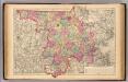
Middlesex County.
1 : 158400 Gray, Ormando Willis; Walling, H. F.
Ware
1 : 125000
Ware
1 : 125000
Map of the country about Worcester
1 : 62500 Appalachian Mountain Club W.B.Clarke & Co.
Marlboro quadrangle, Massachusetts
1 : 62500 Geological Survey (U.S.) U.S. Geological Survey
Barre quadrangle, Massachusetts
1 : 62500 Geological Survey (U.S.) U.S. Geological Survey
Worcester quadrangle, Massachusetts
1 : 62500 Geological Survey (U.S.) U.S. Geological Survey
Map of the town of Gardner, Worcester Co., Mass. : from actual surveys : Western sheet
1 : 19800 Osborne, D. S Richard Clark
Map of the town of Gardner, Worcester Co., Mass. : from actual surveys : Eastern sheet
1 : 19800 Osborne, D. S Richard Clark
Fitchburg quadrangle, Massachusetts
1 : 62500 Geological Survey (U.S.) U.S. Geological Survey
Groton quadrangle, Massachusetts
1 : 62500 Geological Survey (U.S.) U.S. Geological Survey
Brookfield
1 : 62500
Webster
1 : 62500
Blackstone
1 : 62500
Blackstone
1 : 62500
Blackstone
1 : 62500
Blackstone
1 : 62500
Blackstone
1 : 62500
Blackstone
1 : 62500
Blackstone
1 : 62500
Blackstone
1 : 62500
Blackstone
1 : 62500
Brookfield
1 : 62500
Brookfield
1 : 62500
Brookfield
1 : 62500
Brookfield
1 : 62500
6. Brookfield sheet.
1 : 62500 Geological Survey (U.S.)
Brookfield
1 : 62500
Brookfield
1 : 62500
Brookfield
1 : 62500
7. Webster sheet.
1 : 62500 Geological Survey (U.S.)
Blackstone
1 : 62500
Blackstone
1 : 62500
Webster
1 : 62500
Webster
1 : 62500
Webster
1 : 62500
Webster
1 : 62500
Webster
1 : 62500
Webster
1 : 62500
Webster
1 : 62500
Webster
1 : 62500
Webster
1 : 62500
18. Brookfield sheet.
1 : 62500 Massachusetts. Topographical Survey Commission
Brookfield
1 : 62500
21. Webster sheet.
1 : 62500 Massachusetts. Topographical Survey Commission
24. Blackstone sheet.
1 : 62500 Massachusetts. Topographical Survey Commission
Webster
1 : 62500