Maps of Cambridge
Plan of Cambridge
1 : 10560 W.A. Mason & Son Greenough & Co.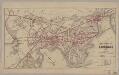
Map of the city of Cambridge for 1865
1 : 12672 Chase, J. G J.H. Bufford's Lith.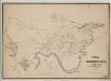
A map of Cambridge, Mass
1 : 12000 Hayward, James, 1786-1866 Eddy's Lithography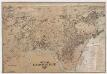
City of Cambridge, Mass
[s.n.]
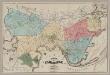
Map of the city of Cambridge, Middlesex County, Massachusetts
1 : 6000 Walling, Henry Francis, 1825-1888 Geo. L. Dix
A plan of those parts of Boston and the towns in its vicinity : with the waters and flats adjacent which are immediately or remotely connected with the contemplated design of erecting perpetual tide-mills
1 : 15840 Dearborn, Benjamin, 1754-1838 Benjamin Dearborn
A plan of those parts of Boston, and the towns in its vicinity, with the waters and flats adjacent, which are immediately or remotely connected with the contemplated design of erecting perpetual tide-mills

Plan of the town of Brighton : made by order of the selectmen from actual surveys : Eastern sheet
1 : 3600 Wightman, H. M A. Meisel
Plan of the town of Brighton : made by order of the selectmen from actual surveys : Western sheet
1 : 3600 Wightman, H. M A. Meisel
This plan drawn from a scale of 200 ft. to an in. : [Cambridgeport, Massachusetts]
1 : 2400 Tufts, Peter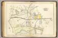
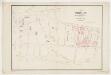
35. Wards 9-11.
1 : 3600 Bromley, George Washington; Bromley, Walter Scott
An accurate plan of the town of Boston and its vicinity : exhibiting a ground plan of all the streets, lanes, alleys, wharves, and public buildings in Boston, with the names and description thereof, likewise all the flats and channels between Boston and Charlestown, Cambridge, Roxbury & Dorchester with the two bridges and causeway, and the boundary lines beween Boston and the above mentioned towns from ...
1 : 4170 Carleton, Osgood, 1742-1816 Published and sold by Osgood Carleton
Boston, Birthplace of the Telephone : A Pictorial Map of the Down Town Area
Chase, Ernest Dudley, 1878-1966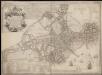
A new plan of ye great town of Boston in New England in America, with the many additionall buildings & new streets to the year 1743

Sketch of the Action on the Heights of Charlestown.
Melish, John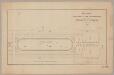
Part of a plan presented to the Commissioners for the improvement of the Back Bay
1 : 2400 T. & J. Doane (Firm) s.n.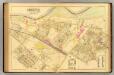
35. Ward 25 Brighton.
1 : 2400 Richards, L. J.
Map of Fresh Pond : showing the division lines of the proprietors extended into the pond and defining their right to the same as decided by Simon Greenleaf & S.M. Felton, commissioners
1 : 2400 Parker, George A E.W. Bouvé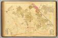
36. Ward 25 Brighton.
1 : 2400 Richards, L. J.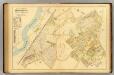
37. Ward 25 Brighton.
1 : 2400 Richards, L. J.
Plan of the village in old Cambridge
1 : 1200 Wadsworth, Alexander, 1806-1898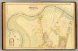
33. Ward 25 Brighton.
1 : 2400 Richards, L. J.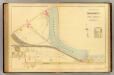
34. Ward 25 Brighton.
1 : 2400 Richards, L. J.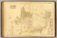
38. Ward 25 Brighton.
1 : 2400 Richards, L. J.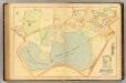
40. Ward 25 Brighton.
1 : 2400 Richards, L. J.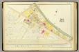
1. Ward 4.
1 : 1200 Bromley, George Washington; Bromley, Walter Scott
A plan of a part of the land belonging to the honorable Frances Dana, Esqr. lying in Cambridge
1 : 1980 Tufts, Peter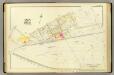
3. Ward 6.
1 : 1200 Bromley, George Washington; Bromley, Walter Scott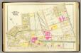
9. Wards 2-4.
1 : 1200 Bromley, George Washington; Bromley, Walter Scott