Maps of Seven Seas (Open Ocean)

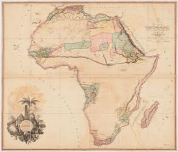
Africa
1 : 6500000 Arrowsmith, Aaron, 1750-1823 A. Arrowsmith, Rathbone Place
Oceanica, Sandwich Islands.
1 : 70000000 Mitchell, Samuel Augustus
Oceanica, Sandwich Islands.
1 : 70000000 Mitchell, Samuel Augustus
Oceanica, Sandwich Islands.
1 : 70000000 Mitchell, Samuel Augustus Jr.
Oceanica, Sandwich Islands.
1 : 70000000 Mitchell, Samuel Augustus
Oceanica, Sandwich Islands.
1 : 70000000 Mitchell, Samuel Augustus
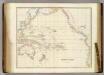
Map Of Oceanica.
1 : 100000000 Mitchell, Samuel Augustus
Grosser Ocean.
1 : 75000000 Andree, Richard
Oceania, or Islands in the Pacific Ocean.
1 : 41000000 Fullarton, A. & Co.
Pacific.
1 : 75000000 Andree, Richard; Times (London, England)
Pacific Ocean.
1 : 50000000 Letts, Son & Co.
Pacific Ocean
1 : 35000000 Aleutské ostrovy (Aljaška) National Geographic Society
Pacific Ocean.
1 : 35000000 Arrowsmith, John
Oceanie.
1 : 29500000 Brue, Adrien Hubert, 1786-1832
Oceana Or Pacific Ocean.
1 : 55000000 Tanner, Henry S.
Oceana Or Pacific Ocean.
1 : 55000000 Tanner, Henry S.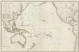
Composite: Oceanie.
1 : 15500000 Brue, Adrien Hubert, 1786-1832
Pacific Ocean.
1 : 90000000 Arrowsmith, Aaron; Lewis, Samuel
Oceana Or Pacific Ocean.
1 : 57500000 Mitchell, Samuel Augustus
Magnum Mare del Zur cum insula California
1 Karte : Kupferdruck ; 49 x 55 cm Renard by L. Renard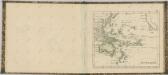
Pacific Ocean.
1 : 40000000 Arrowsmith, John
Pacific Ocean.
1 : 50000000 Society for the Diffusion of Useful Knowledge (Great Britain)
Pacific Ocean including Oceania.
1 : 47000000 Mitchell, Samuel Augustus
Pacific Ocean including Oceania.
1 : 47000000 Mitchell, Samuel Augustus
Pacific Ocean : compiled from Admiralty surveys & other official sources
1 : 15000000 India-Rubber, Gutta-Percha & Telegraph Works Co J.D. Potter
Longueurs du pendule.
1 : 75000000 L'Isle, Guillaume de, 1675-1726
A chart of the discoveries made by the late Capt. Cook, & other European navigators, in the great Pacific Ocean between Asia and America
Kitchin, Thomas Baldwin, Richard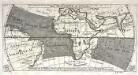
Réprésentation du cours ordinaire des vents de traverse qui regnent le long des côtes dans la mer Atlantique [et] celle des Indes
1 Karte : Kupferdruck ; 15 x 30 cm Cosmant Didot