Maps of Kolkata

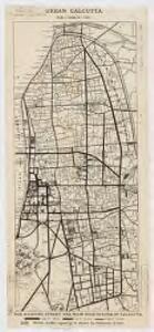
Urban Calcutta : the existing street and main road system of Calcutta
1 : 21120 Richards, E. P Calcutta Improvement Trust
Traffic intensities
1 : 10560 Richards, E. P Calcutta Improvement Trust?]
Map of Calcutta with pictorial insets
Engraved map with pictorial inserts of Calcutta in West Bengal by an unknown engraver published in 1842 under the superintendence of the Society for the Diffusion of Useful Knowledge. Calcutta was founded by Job Charnock in 1690. Thanks to its position on the River Hooghly, a tributary of the Ganges, Calcutta soon became the largest port in the region. The city was also known as 'The City of Palaces', due to the impressive array of public buildings along Esplanade Row and Chowringhee Road. The three pictorial inserts along the bottom edge of the map show Writers' Buildings, Government House and Esplanade Row. The Writer's Building is located on the north side of Tank Square, later Dalhousie Square and now BBD Bagh. It was built as the headquarters of the East India Company by Thomas Lyon in 1777. In front of the building is the monument erected by John Zephaniah Holwell to the memory of the survivors of the 'Black Hole' of 1756. Marquess Wellesley commissioned the building of the new Government House on his appointment to Governor-General in 1798. The architect, Captain Charles Wyatt of the Engineers, based his designs for the building on Kedleston Hall in Derbyshire. 'This view shows the southern facade. There is a circular colonnade with a dome in the centre and two projecting wings either side. Esplanade Row runs east-west to the north of the Maidan, the open space in which the new Fort William was built in 1757. By the close of the eighteenth century, Esplanade Row was the location of numerous public buildings. The new Government House is shown on the right.
Plan of Calcutta
Maps described in the 1878 published catalogue Survey of India
Plan of Calcutta
1 : 11000 Kalkata (Indie) Surveyor general's office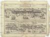
Calechvt celeberrimvm Indiae emporivm
Kalkata (Indie) Braun, Georg Hogenberg, Franz
Calcutta
1 : 38000 Kalkata (Indie) Society for the Diffusion of Useful Knowledge
Calcutta
1 : 21500 Society for the Diffusion of Useful Knowledge (Great Britain) published under the superintendence of the Society for the Diffusion of Useful Knowledge [by] George Cox
Route map : Calcutta & Howrah
1 : 21120 Calcutta Tramways Company Calcutta Tramways Co.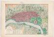
Map of the city and environs of Calcutta : constructed chiefly from Major Schalch's map and from Captain Prinsep's surveys of the suburbs with the latest improvements and topographic details
1 : 21450 Tassin, Jean-Baptiste Athanase, 1800-1868 J.B. Tassin
City of Calcutta
1 : 21120 Richards, E. P Printed by Jennings & Bewley?
City of Calcutta : sociological map
1 : 21120 Survey of India Taylor, Garnett, Evans & Co.
Bengal & Chandernagore, No 79 B, Calcutta
India And Adjacent Countries 1:253,440 or 1" = 4 miles maps Survey of India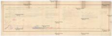
A geological, botanical, ethnological, statistical or physical section of the districts of Beerbhoom and Moorshedabad in Bengal 1853
Bengálsko Sherwill, Walter Stanhope Surv. gen. office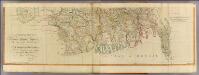
Bengal, Bahar &c. (south)
1 : 750000 Robert Laurie & James Whittle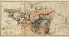
Gold, copper and lead in Chota Nagpore
This is the map contained within the 176-page volume Gold, copper and lead in Chota Nagpore and the adjacent country, compiled by W. King and T.A. Pope and published in Calcutta. King, W., F.G.S. (William) Calcutta : Thacker, Spink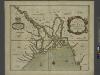
A mapp of the greate river GANGES as ir emptieth it selfe into the bay of BENGALA
from The sea-atlas : containing an hydrographical description of most of the sea-coasts of the known parts of the world.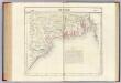
Bengale. Asie 95.
1 : 1641836 Vandermaelen, Philippe, 1795-1869
India 8.
1 : 2217600 Letts, Son & Co.
India VIII. Bengal Presidency.
1 : 2200000 Society for the Diffusion of Useful Knowledge (Great Britain)
Karte von Asam, Ost-Bengalen und Nord-Birma
1 : 2275000 Bengálsko Mahlmann, Heinrich Etzel, Franz August von D. Reimer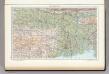
142. Lower Ganga (Ganges) Valley. The World Atlas.
1 : 2500000 USSR (Union of Soviet Socialist Republics).
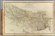
The Province of Bengal
India Office reference collection of maps Survey of India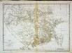
Carte du Bengale et de ses dépendances
1 Karte : Kupferdruck ; 37 x 53 cm Bolts s.n.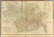
Composite: Bengal, Bahar &c.
1 : 750000 Robert Laurie & James Whittle
Bengal Etc.
1 : 3380000 Sharpe, J.
Provinces of the Lower Ganges.
1 : 2000000 John Bartholomew & Co.
The Province of Bengal and Assam
India Office reference collection of maps Survey of India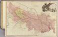
Bengal, Bahar, Oude, Allahabad.
1 : 1480000 Rennell, James, 1742-1830
Gangetic Hindoostan or the countries occupied by the Ganges and the branches
1 : 7000000 Cary, John, ca. 1754-1835 J. Cary