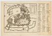
Maps of Copenhagen Municipality

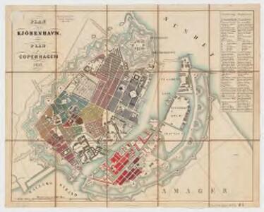
Plan af Kjöbenhavn = Plan of Copenhagen
1 : 8857 Em. Baerentzen & Co Em. Baerentzen & Co.
COPPENHAGEN die königl. Dänische Haupt und Residentz Stadt
Kodaň (Dánsko) Seutter, Matthäus Kraus, Johann Thomas von Matth. Seutter
Coppenhagen die königl. dänische Haupt und Residentz Stadt
Kodaň (Dánsko) Kraus, Johann Thomas Seutter, Matthäus Matth. Seutter
Grundriss von Kopenhagen
1 : 10000 Lithographie von Asch, in Berlin Stettin : Morin
Naaukeurige Aftekening van de Koninglyke Deensche Hoofd en Residentie STAD KOPENHAGEN
Kodaň (Dánsko) Ottens, Josua uitgegeven door Reinier & Josua Ottens
PLAN von KOPENHAGEN
Kodaň (Dánsko)
Plan von Kopenhagen
Kodaň (Dánsko) Call, Jan van Niebuhr, Carsten
Grund tegning af den kongelige reisdenz stad Kiøbenhavn
Fridrich, Johann Gottlieb, 1742-1809
Plan af Kjöbenhavn med Forstaeder

Kopenhagen
1 : 21500 Kodaň (Dánsko) Bibliographisches Institut
Copenhagen
Naaukeurige aftekening van de koninglyke Deensche hoofd en residentie stad Koppenhagen : met de aftekening van de swaren brand op den 20 October en volgende dagen A° 1728
Ottens, R. (Reinier), 1698-1750 Reinier & Josua Ottens
Copenhagen
Grosser Hand-Atlas über alle Theile der Erde in 170 Karten Meyer, J. Verlag des Bibliographischen Instituts
Kopenhagen
1 : 27700 Kodaň (Dánsko) F.A. Brockhaus' geogr.-artist. Anstalt
Copenhagen = (Kiöbenhaven)
1 : 12500 Clarke, W. B published by the Superintendence of the Society for the Diffusion of Useful Knowledge [by] George Cox
Kjöbenhavn : med nærmeste omegn 1903
1 : 10000 Kjøbenhavns Kommunes Foranstaltning Kjøbenhavns Kommunes Ejendomme
Ostsee
1 : 100000 Baltské moře Reichs-Marine-Amt
Den nordöstlige Deel af Sjælland
1 : 160000 samlet, tegnet og lithogr. af J.H. Mansa [København] : trykt i det Kongl. Steentr.
Strait Denmark-Sweden.
1 : 150000 Nordenankar, J.
Kjöbenhavn 4, uit: Special-Karte von Mittel-Europa / nach amtlichen Quellen bearbeitet von W. Liebenow
1 : 300000 titelvariant: W. Liebenow's Mittel-Europa; Annotatie: Titel boven de bladen: W. Liebenow's Mittel-Europa Johannes Wilhelm Liebenow 1822-1897 Frankfurt a. M. : Ludwig Ravenstein
SCANIA | Vulgo | SCHOONEN.
[Amsterdam : Joan Blaeu]
Scania, Vulgo Schonen. [Karte], in: Novus atlas absolutissimus, Bd. 1, S. 122.
1 Karte aus Atlas Janssonius Offizin

ZEELANDIA | INSVLA | Danicarum Maxima.
[Amsterdam : Joan Blaeu]
Nova et accurata Scaniae et maximae partis Zeelandiae tabula
1 : 325000 A Amsterdam : chez Jean Cóvens et Corneille Mortier
Selandiae In Regno Daniae Insulae Chorographica Descriptio. [Karte], in: Novus atlas absolutissimus, Bd. 1, S. 125.
1 Karte aus Atlas Janssonius Offizin
Sect. 2: Stralsund, uit: Geologische Karte des Deutschen Reichs in 27 Blaettern / [von] Richard Lepsius ; Red. von C. Vogel
1 : 500000 Annotatie: Blad 18 ontbreekt; Een aantal bladen op linnen; Een aantal bladen gereviseerd 1913-1914; Annotatie geografische gegevens: Met schaalstokken o.a. in kilometers; Legenda Carl Vogel 1828-1897 Gotha : Justus Perthes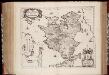
Zeelandia insvla : Danicarum maxima
1 : 390000 Annotatie: Met opdracht van Joan Blaeu aan Petrus Charisius; Origineel is Blad 145 in atlas factice; Annotatie geografische gegevens: Met schaalstok [Amsterdam] : [Joan Blaeu]
Insvlae Danicae in Mari Balthico sitae utpote Zeelandia, Fionia, Langelandia, Lalandia, Falstria, Fembria Mona repraesentatae
1 : 470000 Baltské moře-oblast Homann, Johann Baptist J.B. Homann