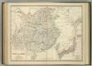
Maps of Inner Mongol
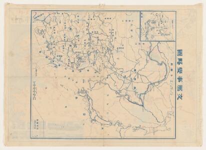
上海事變明細圖解 : 中支戰況要圖
上海事變明細圖解:中支戰況要圖 昭和十二年[1937]9月5日,东京:东京日日新聞社 该图反映的是1937年“八一三事变”初期日军对上海、南京、杭州及铁道沿线地区的大规模轰炸形势,以及国民党军队的军事部署状况。空间范围即长三角一带。 插图1幅《上海附近》,详细标注日军对上海华界的轰炸地和国军部队部署状况。 背面为《支那事變略圖》,比例尺为1:10000000。 2图,彩色,日文,图幅37 x 52 cm,主图无比例尺和经纬线。 Harvard-YenchingManchuguo J-0872;Hollis Number:014634349 东京日日新聞社
Karte von China mit dessen Eintheilung in 18 Provinzen
1 : 6500000 Roost, J. B Verlag der liter. artist. Anstalt der L.G. Cotta'schen Buchhandlung
Carte des missions catholiques en Chine
1 : 5500000 Launay, Adrien 1853-1927 [Lyon : Oeuvre de la propagation de la foi]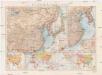
Politische Karte von China
1 : 10000000 Japonsko Scobel, Albert Velhagen & Klasing
Political Map of China showing Christian Mission Stations
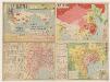
廣東香港明細地圖. 漢口南昌明細地圖
1 : 820000 廣東香港明細地圖•漢口南昌明細地圖 昭和十三年[1938]3月1日,淵田忠良 编辑,东京:大日本雄辯會講談社 正面为《廣東香港明細地圖》,以珠三角为中心的行政图,包括香港,绘制了铁路、公路、河网和航空线,标注了县治及部分乡镇地名。附插图3幅:《汕頭附近》,为粤东地区行政区划图;《廣東》,为广州城地形简图;《香港》为维多利亚海湾两岸等高线地形图。 背面为《漢口南昌明細地圖》,西起洞庭湖,东至太湖西侧,南抵湖南、江西中部的湘潭-抚州一线,北达南京、信阳一带,以长江中游汉口-南昌-南京为中心,包括洞庭湖、鄱阳湖、巢湖等。绘制了该区域较为详细的村镇地名和交通线。 背面的汉口图较广东图详细,应与此时日军正大举进攻长江中游,并即将发动武汉会战的战争局势密切相关。 2图,黑蓝双色,日文,图幅39.5 x 54.5 cm,比例尺分别为1:820,000和1:1,500,000,无经纬线。 Harvard-YenchingManchuguo J-0886;Hollis Number:014636952 淵田忠良 大日本雄辯會講談社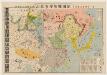
北支事變明細圖解 : 日·満·露·支·蒙·関係一覽.
北支事變明細圖解 昭和十二年[1937]8月22日 东京:東京日日新聞社 此图是在《東亜危機明細図解》(014623780)上修改而成,主图内容是1937年中国的军事形势,东北地区中苏边界上,苏联部署重兵包围了伪满洲国。华北地区沦陷并成立了冀东傀儡政权。国民党主要控制淮河以南地区。 插图1幅《北支事變要圖》。 1图,彩色,日文,图幅53.6 x 77.2 cm,无比例尺和经纬线。 Harvard-YenchingManchuguo J-0828;Hollis Number:014623845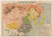
東亜危機明細図解 : 恐るべし日満包囲馬蹄陣形 : 日満露支蒙関係一覧.
東亜危機明細図解:恐るべし日満包囲馬蹄陣形 昭和十一年[1936]10月10日,东京:东京日日新聞社 该图标示出苏联红军重兵包围东北,沿着东北中苏边界修筑防线,进而形成对东北和华北地区的马蹄形包围。同时,苏联从西北方向中国输送物质弹药,西北地区已赤化,并不断向东推进。华北地区则有多个国民党军头控制,淮河以南地区除了广西外,主要由蒋介石中央政府控制,并向北推进。该图用图画标注各地主要物产,并用贴了各地军政首脑头像。 1图,彩色,日文,图幅53.5 x 77.6 cm,无比例尺和经纬度线。 Harvard-YenchingManchuguo J-0822;Hollis Number:014623780 东京日日新聞社
萬國通鑑:中國地圖
美国传教士撰的向中国人介绍世界地理概况的著作,后有世界地图册1份,共13幅世界、大洲和区域地图,其中一幅题为《中國地圖》的清朝内地地图。 Sheffield, Devello Zelotos 謝衛樓 福州 : 美華書局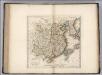
China.
1 : 10500000 Carey, Mathew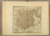
China.
1 : 10500000 Carey, Mathew
China, divided into it's Great Provinces.
1 : 12672000 Carey, Mathew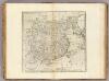
China divided into it's Great Provinces.
1 : 12672000 Carey, Mathew
China divided into it's Great Provinces.
1 : 12672000 Carey, Mathew
Carte generale de la Chine

China, Corea.
1 : 15700000 Bowen, Frances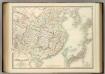
China and Japan.
1 : 6198300 Johnston, Alexander Keith
China.
1 : 13000000 Tanner, Henry S.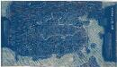
大清萬年一統地理全圖
大清萬年一統地理全圖 嘉庆十八至二十年(1814-1816年),黄千人原作 此图根据乾隆年间黄千人《大清万年一统天下全图》增补翻刻而成。黄千人制图之时,大小金川、新疆、西藏等尚未平定,河口海岸也有所偏差,此版修订反映乾隆至嘉庆年间的新变化。其空间范围西起帕米尔、东至朝鲜、南抵南海、北达黑龙江。陆地部分为蓝底白字,海水则绘制碧波纹,图幅广大,壮阔明朗,全图分为八条屏幅印制,以便于旅途携带,供“博雅君子悬壁纵观天下之广”。 黄千人(1694-1771),字证孙,浙江余姚人,乾隆三十二年(1767)将其祖父黄宗羲旧刻舆图重订为《大清万年一统天下全图》并付梓。燕京馆藏本是据1767年本的翻刻本,翻刻时间约1814至1816年间。 1图,蓝色刻本,中文,128 x 228 cm,计里画方,每方百里。 Harvard-Yenching | Rare Book | T 3080.8 4831;Hollis Number:009747467 黃千人 缺
大明九辺萬國人跡路程全圖.
大明九辺萬國人跡路程全圖 日本:帝幾書坊梅村彌白翻刻。 此图翻刻自康熙二年[1663] 王君甫的《天下九邊萬國人跡路程全圖》,内容一致,只是将图题和图下解说中的“天下”改为“大明”,并未着色而已。具体见“天下九邊萬國人跡路程全圖”条目。 1图,黑白刻本,中文,图幅122.5 x 122.8 cm,无比例尺和经纬度。 Harvard-Yenching | Rare Book | TJ 3080 4643 F,Hollis Number:008628419 帝幾書坊梅村彌白翻刻
China.
1 : 6000000 John Bartholomew & Co.
Carte Particuliere de la Chine.
1 : 10000000 Vivien de St Martin, L.
China.
1 : 6200000 Robert Laurie & James Whittle
Imperii Sinarvm nova descriptio / auctore Joh van Loon
1 : 6200000 1 Karte : Kupferdruck ; 46 x 51 cm Loon, Jan van Johannes Janssonius]
China.
1 : 7500000 Lizars, Daniel
China.
1 : 13305600 Lucas, Fielding Jr.
China.
1 : 10200000 Bowen, Emanuel
China and Japan
1 : 8820000 Annotatie: Blad 41 uit: Edinburgh imperial atlas. - Edinburgh : Gall & Inglis, 1850 Edinburgh : Lloyd
China.
1 : 13400000 Finley, Anthony