Maps of China

大東亜共榮パノラマ地圖
大東亜共榮パノラマ地圖[大东亚共荣圈全图] 昭和十六年[1941]1月1日,佐藤保太郎 监修,中央地图研究所 制图,原一司 画,东京:株式会社大日本雄辯會講談社 发行。 该图的空间范围包括中国在内的整个东亚和东南亚地区。此图是作为《少年俱楽部》第28卷第1号的附录,面向青少年读者,因而用卡通画标注了各地主要的农牧业物产,以宣传为主要功能。图背为“兵隊さん慰問ゑはがきお手本集”,各类军事相关明信片图案。 1图,彩色,日文,图幅76.7 x 53.4 cm,无比例尺和经纬度线。 Harvard-Yenching | Manchuguo J-0852;Hollis Number:014629855 佐藤保太郎 株式会社大日本雄辯會講談社
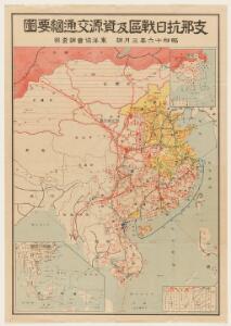
支那抗日戰區及資源交通網要圖
1 : 8000000 支那抗日戰區及資源交通網要圖 昭和十六年[1941]3月,东京:東洋協會調查部 该图空间范围为中国内地及东南亚。绘制了日占区、中国军队部署、中国对外交通线及各地农牧矿业物产资源。 1图,彩色,日文,图幅73 x 50 cm,比例尺1:8,000,000,无经纬度线。 Harvard-YenchingManchuguo J-0838;Hollis Number:014624151 東洋協會調查部
萬國通鑑:亞西亞
美国传教士撰的向中国人介绍世界地理概况的著作,后有世界地图册1份,共13幅世界、大洲和区域地图,其中一幅题为《中國地圖》的清朝内地地图。 Sheffield, Devello Zelotos 謝衛樓 福州 : 美華書局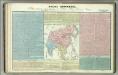
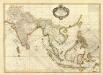
Tableau l'historie de L'Asie, Inde, Chine, Japon.
1 : 33200000 Duval, Henri
Chinae, olim Sinarum regionis, nova descriptio. [Karte], in: Theatrum orbis terrarum, S. 393.
1 Karte aus Atlas Ortelius, Abraham Vrients, Jan Baptista
Chinae, olim Sinarum regionis, nova descriptio. [Karte], in: Theatrum orbis terrarum, S. 298.
1 Karte aus Atlas Ortelius, Abraham
South Eastern Asia.
1 : 16600000 Sharpe, J.
Das Chinesische Reich mit seinen Schutzstaaten
Grosser Hand-Atlas über alle Theile der Erde in 170 Karten Meyer, J. Verlag des Bibliographischen Instituts
China.
from A system of geography, or, A new & accurate description of the earth in all its empires, kingdoms and states : illustrated with history and topography, and maps of every country : fairly engraven on copper, according to the latest discoveries and corrections / by Herman Moll.
Hindoostan, Farther India, China, Tibet.
1 : 17500000 Mitchell, Samuel Augustus
Hindoostan, Farther India, China, Tibet.
1 : 17500000 Mitchell, Samuel Augustus
Hindoostan, Farther India, China, Tibet.
1 : 17500000 Mitchell, Samuel Augustus Jr.
Hindoostan, Farther India, China, Tibet.
1 : 17500000 Williams, W. (Wellington)
East India.
from A new systeme of the mathematicks: containing I. Arithmetick, as well natural and decimal, as in species, or the principles of algebra. II. Practical geometry, together with the first six books of Euclid's Elements, as also the eleventh and twelfth, symbo
Hindoostan, Farther India, China, Tibet.
1 : 17500000 Williams, W. (Wellington)
Map Of Hindoostan, Farther India, China, and Tibet.
1 : 17600000 Mitchell, Samuel Augustus
Map of China, Burma, Siam, Annam & c
1 : 10280000 Hongkong (Čína) G.W. Bacon
Map of Hindoostan, Farther India, China, and Tibet
1 : 18000000 Mitchell, Samuel Augustus Jr.
Das Chinesische Reich mit den Schutz-Staaten und Japan
Stieler's Hand-Atlas Stieler, Adolf bei Justus Perthes
Chinesisches Reich, Japan.
1 : 17000000 Flemming, Carl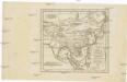
Charte von China und den angränzenden Ländern, und Völkerschaften so wie sie dem letzten Kaiser Tschien-Long unterworfen waren
Čína Kiepert, Heinrich Macartney, George Macartney
Chinesisches Reich
Adolf Stieler's Handatlas über alle Theile der Erde und über das Weltgebäude Stieler, Adolf Justus Perthes
Tabula Asiae VIII. [Karte], in: Geographia universalis vetus et nova complectens Claudii Ptolemaei Alexandrini enarrationis libros VIII, S. 287.
1 Karte aus Atlas Münster, Sebastian [und Ptolemaeus, Claudius]
India Orientalis [Karte], in: Gerardi Mercatoris Atlas, sive, Cosmographicae meditationes de fabrica mundi et fabricati figura, S. 535.
1 Karte aus Atlas Mercator, Gerhard Montanus, Petrus
Ostasiatischer-Raum
1 : 10000000 Asie východní Bibliographisches Institut
Undecima Asiae Tabula [Karte], in: Claudii Ptolemei viri Alexandrini mathematice discipline philosophi doctissimi geographie opus [...], S. 223.
1 Karte aus Atlas Waldseemüller, Martin [und Ptolemaeus, Claudius] Übelin, Georg
China
1 : 9500000
China [Karte], in: Gerardi Mercatoris Atlas, sive, Cosmographicae meditationes de fabrica mundi et fabricati figura, S. 532.
1 Karte aus Atlas Mercator, Gerhard Montanus, Petrus