Maps of Tong'an District

廈門城市全圖
1 : 7500 廈門城市全圖 民国八年(1919年),厦門:全閩新日報社 民国初期厦门城市地图。此图原为1911年全闽新日报社四周年纪念日时发行的赠品图,1919年十二周年纪念时重印。空间范围为厦门岛西侧,但未包括鼓浪屿。较为详细标注各街道名。 1幅,黑白,中文,78 x 55 cm,1: 5,000 Harvard-Yenching | Rare Book | T 3102 0740,Hollis Number:009406147 全閩新日報社 廈門:全閩新日報社
廈門市街圖
1 : 5000 廈門市街圖 1912-1949年 日本绘制的厦门城市街道图,主要为鼓浪屿和厦门岛西侧部分区域。绘制了街道,标注各国领事馆、公司、邮局、医院、寺庙等。郊区山地绘制等高线。成图时间未标注,厦门岛上城内原水师提督署处已改为“司令部”。 1图,黑白,日文,54 x 48.5 cm,1: 8,000 Harvard-Yenching | Rare Book | T 3102 0702,Hollis Number:009406129
Amoy Inner Harbour[廈門內港圖]
Amoy Inner Harbour[廈門內港圖] 1892年11月,W.C. Howard 此为航行图,以鼓浪屿为中心,绘制了厦门港内附近地形、航道、岛屿,并标注海水深度。对鼓浪屿绘制较为详细,厦门岛仅绘制西侧海岸部分,老城内未绘制。 1图,彩色,英文、中文,55 x 69 cm,约1:7500 Harvard-Yenching | Rare Book | T 3102 W92;Hollis Number:009406171 Howard, W.C
Hsia-men
1 : 2500000 United States. Army Map Service. Army Map Service
Amoy and surrounding region, China (1902)
Map of Amoy and surrounding region, which includes Heng-Hoa, Chin-Chew, Chang-Chew, Eng-Chhun, Lung-Yen, and the district round each year, by Rev.L.W.Kip, D.D. London : Unwin Brothers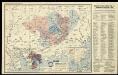
The northeastern part of the southern Chinese province Kwang Tung (Canton) with the mission stations of the Basel, Berlin and Rhenish (Barmer) Mission Societies.

康熙内府分省分府圖:福建全圖
康熙内府分省分府圖 民国己卯年[1939],清内府制,夏孙桐序 康熙年间内地分省分府图,未包括边疆地区。据图前夏孙桐序,此图原为蒋廷锡于康熙年间奉敕编制,图板后失传,夏在光绪年间参与编修会典舆图时,于厂肆间得到此图,后于民国时期石印出版。体例上一省一图,一府一图,有如下图幅: 全图:《山海輿地全圖》和内地总图各一幅,在直隶省后。 直隶:《直隸全圖》《順天府圖》《永平府圖》《保定府圖》《河間府圖》《真定府圖》《順德府圖》《廣平府圖》《大名府圖》《宣化府圖》 盛京:《盛京省全圖》《奉天府南分圖》《奉天府北分圖》《錦州府圖》《鴨綠江圖》《熱河圖》《寧古塔圖》《烏喇圖》《烏蘇里江圖》 江南:《江南全省圖》《江寧府圖》《蘇州府圖》《松江府圖》《常州府圖》《鎮江府圖》《徐州圖》《揚州府圖》《安慶府圖》《徽州府圖》《寧國府圖》《池州府圖》《太平府圖》《廬州府圖》《鳳陽府圖》《廣德州圖》《淮安府圖》《滁州圖》《和州圖》 江西:《江西全圖》《南昌府圖》《饒州府圖》《廣信府圖》《南康府圖》《九江府圖》《建昌府圖》《撫州府圖》《臨江府圖》《吉安府圖》《瑞州府圖》《袁州府圖》《贛州府圖》《南安府圖》; 浙江:《浙江全圖》《杭州府圖》《嘉興府圖》《湖州府圖》《寧波府圖》《紹興府圖》《台州府圖》《金華府圖》《衢州府圖》《嚴州府圖》《溫州府圖》《處州府圖》 福建:《福建全圖》《福州府圖》《泉州府圖》《建寧府圖》《延平府圖》《汀州府圖》《興化府圖》《邵武府圖》《漳州府圖》《福寧州圖》《台灣府圖》 河南:《河南全圖》《開封府圖》《歸德府圖》《彰德府圖》《衞輝府圖》《懷慶府圖》《河南府圖》《南陽府圖》《汝寧府圖》《汝州圖》 湖广:《湖廣全圖》《武昌府圖》《漢陽府圖》《安陸府圖》《襄陽府圖》《隕陽府圖》《德安府圖》《黃州府圖》《荊州府圖》《長沙府圖》《岳州府圖》《寶慶府圖》《衡州府圖》《常德府圖》《辰州府圖》《永州府圖》《永順保靖二司圖》《九谿永定二衞圖》《靖州圖》《施州衞圖》 山东:《山東全圖》《濟南府圖》《兗州府圖》《東昌府圖》《青州府圖》《登州府圖》《萊州府圖》 陕西:《陝西全圖》《西安府圖》《西安府北圖》《西安府南圖》《鳳翔府圖》《漢中府圖》《延安府圖》《延安府北圖》《延安府南圖》《平涼府圖》《平涼府西北圖》《平涼府南圖》《鞏昌府圖》《鞏昌府北圖》《鞏昌府南圖》《臨洮府圖》《臨洮府圖南》《慶陽府圖》《寧夏鎮圖》《興安州圖》《涼州圖蘭州西北》《延綏鎮圖》《河套北圖》《河套南圖》《甘肅鎮圖》《甘肅鎮圖涼州西北》《蘭州圖臨洮府西北》 山西:《山西全圖》《太原府圖》《平陽府圖》《潞安府圖》《汾州府圖》《沁州圖》《澤州圖》《遼州圖》《大同府圖》 四川:《四川全圖》《成都府圖》《保寧府圖》《順慶府圖》《敘州府圖》《重慶府圖》《夔州府圖》《龍安府圖》《馬湖府圖》《遵義府圖》《東川府附鎮雄烏蒙二土府圖》《潼川州圖》《嘉定州圖》《雅州圖》《瀘州圖》《眉州圖》《建昌衞所屬衞所南圖》《建昌衞所屬衞所北圖》《建昌衞所屬衞所中圖》《松潘衞圖》《邛州圖》 广东:《廣東全圖》《廣州府圖》《韶州府圖》《南雄府圖》《惠州府圖》《潮州府圖》《肇慶府圖》《高州府圖》《廉州府圖》《雷州府圖》《瓊州府圖》《羅定州圖》 广西:《廣西全圖》《桂林府圖》《柳州府北圖》《柳州府南圖》《慶遠府圖》《思恩府圖》《平樂府圖》《梧州府圖》《潯州府圖》《南寧府圖》《太平府圖》《思明府圖》 云南:《雲南全圖》《雲南府圖》《大理府圖》《楚雄府圖》《臨安府圖》《景東府圖》《澂江府圖》《廣西府圖》《廣南府圖》《曲靖府圖》《順寧府圖》《鶴慶府圖》《姚安府圖》《麗江府圖》《武定府圖》《蒙化府圖》《元江府圖》《永北府圖》《永昌府圖》《鎮沅府圖》《開化府圖》《孟定土府》《永寧府圖》 贵州:《貴州全圖》《貴陽府圖》《思州府圖》《思南府圖》《鎮遠府圖》《石阡府圖》《銅仁府圖》《黎平府圖》《安順府圖》《威寧府圖》《都勻府圖》《平越府圖》《郴州圖》。 8册231图,黑白石印,经折装,中文,图幅为28.3 x 34.5 cm。 Harvard-Yenching | Rare Book | T 3080 0789;Hollis Number:010244054 清内府
康熙内府分省分府圖:福州府圖
康熙内府分省分府圖 民国己卯年[1939],清内府制,夏孙桐序 康熙年间内地分省分府图,未包括边疆地区。据图前夏孙桐序,此图原为蒋廷锡于康熙年间奉敕编制,图板后失传,夏在光绪年间参与编修会典舆图时,于厂肆间得到此图,后于民国时期石印出版。体例上一省一图,一府一图,有如下图幅: 全图:《山海輿地全圖》和内地总图各一幅,在直隶省后。 直隶:《直隸全圖》《順天府圖》《永平府圖》《保定府圖》《河間府圖》《真定府圖》《順德府圖》《廣平府圖》《大名府圖》《宣化府圖》 盛京:《盛京省全圖》《奉天府南分圖》《奉天府北分圖》《錦州府圖》《鴨綠江圖》《熱河圖》《寧古塔圖》《烏喇圖》《烏蘇里江圖》 江南:《江南全省圖》《江寧府圖》《蘇州府圖》《松江府圖》《常州府圖》《鎮江府圖》《徐州圖》《揚州府圖》《安慶府圖》《徽州府圖》《寧國府圖》《池州府圖》《太平府圖》《廬州府圖》《鳳陽府圖》《廣德州圖》《淮安府圖》《滁州圖》《和州圖》 江西:《江西全圖》《南昌府圖》《饒州府圖》《廣信府圖》《南康府圖》《九江府圖》《建昌府圖》《撫州府圖》《臨江府圖》《吉安府圖》《瑞州府圖》《袁州府圖》《贛州府圖》《南安府圖》; 浙江:《浙江全圖》《杭州府圖》《嘉興府圖》《湖州府圖》《寧波府圖》《紹興府圖》《台州府圖》《金華府圖》《衢州府圖》《嚴州府圖》《溫州府圖》《處州府圖》 福建:《福建全圖》《福州府圖》《泉州府圖》《建寧府圖》《延平府圖》《汀州府圖》《興化府圖》《邵武府圖》《漳州府圖》《福寧州圖》《台灣府圖》 河南:《河南全圖》《開封府圖》《歸德府圖》《彰德府圖》《衞輝府圖》《懷慶府圖》《河南府圖》《南陽府圖》《汝寧府圖》《汝州圖》 湖广:《湖廣全圖》《武昌府圖》《漢陽府圖》《安陸府圖》《襄陽府圖》《隕陽府圖》《德安府圖》《黃州府圖》《荊州府圖》《長沙府圖》《岳州府圖》《寶慶府圖》《衡州府圖》《常德府圖》《辰州府圖》《永州府圖》《永順保靖二司圖》《九谿永定二衞圖》《靖州圖》《施州衞圖》 山东:《山東全圖》《濟南府圖》《兗州府圖》《東昌府圖》《青州府圖》《登州府圖》《萊州府圖》 陕西:《陝西全圖》《西安府圖》《西安府北圖》《西安府南圖》《鳳翔府圖》《漢中府圖》《延安府圖》《延安府北圖》《延安府南圖》《平涼府圖》《平涼府西北圖》《平涼府南圖》《鞏昌府圖》《鞏昌府北圖》《鞏昌府南圖》《臨洮府圖》《臨洮府圖南》《慶陽府圖》《寧夏鎮圖》《興安州圖》《涼州圖蘭州西北》《延綏鎮圖》《河套北圖》《河套南圖》《甘肅鎮圖》《甘肅鎮圖涼州西北》《蘭州圖臨洮府西北》 山西:《山西全圖》《太原府圖》《平陽府圖》《潞安府圖》《汾州府圖》《沁州圖》《澤州圖》《遼州圖》《大同府圖》 四川:《四川全圖》《成都府圖》《保寧府圖》《順慶府圖》《敘州府圖》《重慶府圖》《夔州府圖》《龍安府圖》《馬湖府圖》《遵義府圖》《東川府附鎮雄烏蒙二土府圖》《潼川州圖》《嘉定州圖》《雅州圖》《瀘州圖》《眉州圖》《建昌衞所屬衞所南圖》《建昌衞所屬衞所北圖》《建昌衞所屬衞所中圖》《松潘衞圖》《邛州圖》 广东:《廣東全圖》《廣州府圖》《韶州府圖》《南雄府圖》《惠州府圖》《潮州府圖》《肇慶府圖》《高州府圖》《廉州府圖》《雷州府圖》《瓊州府圖》《羅定州圖》 广西:《廣西全圖》《桂林府圖》《柳州府北圖》《柳州府南圖》《慶遠府圖》《思恩府圖》《平樂府圖》《梧州府圖》《潯州府圖》《南寧府圖》《太平府圖》《思明府圖》 云南:《雲南全圖》《雲南府圖》《大理府圖》《楚雄府圖》《臨安府圖》《景東府圖》《澂江府圖》《廣西府圖》《廣南府圖》《曲靖府圖》《順寧府圖》《鶴慶府圖》《姚安府圖》《麗江府圖》《武定府圖》《蒙化府圖》《元江府圖》《永北府圖》《永昌府圖》《鎮沅府圖》《開化府圖》《孟定土府》《永寧府圖》 贵州:《貴州全圖》《貴陽府圖》《思州府圖》《思南府圖》《鎮遠府圖》《石阡府圖》《銅仁府圖》《黎平府圖》《安順府圖》《威寧府圖》《都勻府圖》《平越府圖》《郴州圖》。 8册231图,黑白石印,经折装,中文,图幅为28.3 x 34.5 cm。 Harvard-Yenching | Rare Book | T 3080 0789;Hollis Number:010244054 清内府
康熙内府分省分府圖:泉州府圖
康熙内府分省分府圖 民国己卯年[1939],清内府制,夏孙桐序 康熙年间内地分省分府图,未包括边疆地区。据图前夏孙桐序,此图原为蒋廷锡于康熙年间奉敕编制,图板后失传,夏在光绪年间参与编修会典舆图时,于厂肆间得到此图,后于民国时期石印出版。体例上一省一图,一府一图,有如下图幅: 全图:《山海輿地全圖》和内地总图各一幅,在直隶省后。 直隶:《直隸全圖》《順天府圖》《永平府圖》《保定府圖》《河間府圖》《真定府圖》《順德府圖》《廣平府圖》《大名府圖》《宣化府圖》 盛京:《盛京省全圖》《奉天府南分圖》《奉天府北分圖》《錦州府圖》《鴨綠江圖》《熱河圖》《寧古塔圖》《烏喇圖》《烏蘇里江圖》 江南:《江南全省圖》《江寧府圖》《蘇州府圖》《松江府圖》《常州府圖》《鎮江府圖》《徐州圖》《揚州府圖》《安慶府圖》《徽州府圖》《寧國府圖》《池州府圖》《太平府圖》《廬州府圖》《鳳陽府圖》《廣德州圖》《淮安府圖》《滁州圖》《和州圖》 江西:《江西全圖》《南昌府圖》《饒州府圖》《廣信府圖》《南康府圖》《九江府圖》《建昌府圖》《撫州府圖》《臨江府圖》《吉安府圖》《瑞州府圖》《袁州府圖》《贛州府圖》《南安府圖》; 浙江:《浙江全圖》《杭州府圖》《嘉興府圖》《湖州府圖》《寧波府圖》《紹興府圖》《台州府圖》《金華府圖》《衢州府圖》《嚴州府圖》《溫州府圖》《處州府圖》 福建:《福建全圖》《福州府圖》《泉州府圖》《建寧府圖》《延平府圖》《汀州府圖》《興化府圖》《邵武府圖》《漳州府圖》《福寧州圖》《台灣府圖》 河南:《河南全圖》《開封府圖》《歸德府圖》《彰德府圖》《衞輝府圖》《懷慶府圖》《河南府圖》《南陽府圖》《汝寧府圖》《汝州圖》 湖广:《湖廣全圖》《武昌府圖》《漢陽府圖》《安陸府圖》《襄陽府圖》《隕陽府圖》《德安府圖》《黃州府圖》《荊州府圖》《長沙府圖》《岳州府圖》《寶慶府圖》《衡州府圖》《常德府圖》《辰州府圖》《永州府圖》《永順保靖二司圖》《九谿永定二衞圖》《靖州圖》《施州衞圖》 山东:《山東全圖》《濟南府圖》《兗州府圖》《東昌府圖》《青州府圖》《登州府圖》《萊州府圖》 陕西:《陝西全圖》《西安府圖》《西安府北圖》《西安府南圖》《鳳翔府圖》《漢中府圖》《延安府圖》《延安府北圖》《延安府南圖》《平涼府圖》《平涼府西北圖》《平涼府南圖》《鞏昌府圖》《鞏昌府北圖》《鞏昌府南圖》《臨洮府圖》《臨洮府圖南》《慶陽府圖》《寧夏鎮圖》《興安州圖》《涼州圖蘭州西北》《延綏鎮圖》《河套北圖》《河套南圖》《甘肅鎮圖》《甘肅鎮圖涼州西北》《蘭州圖臨洮府西北》 山西:《山西全圖》《太原府圖》《平陽府圖》《潞安府圖》《汾州府圖》《沁州圖》《澤州圖》《遼州圖》《大同府圖》 四川:《四川全圖》《成都府圖》《保寧府圖》《順慶府圖》《敘州府圖》《重慶府圖》《夔州府圖》《龍安府圖》《馬湖府圖》《遵義府圖》《東川府附鎮雄烏蒙二土府圖》《潼川州圖》《嘉定州圖》《雅州圖》《瀘州圖》《眉州圖》《建昌衞所屬衞所南圖》《建昌衞所屬衞所北圖》《建昌衞所屬衞所中圖》《松潘衞圖》《邛州圖》 广东:《廣東全圖》《廣州府圖》《韶州府圖》《南雄府圖》《惠州府圖》《潮州府圖》《肇慶府圖》《高州府圖》《廉州府圖》《雷州府圖》《瓊州府圖》《羅定州圖》 广西:《廣西全圖》《桂林府圖》《柳州府北圖》《柳州府南圖》《慶遠府圖》《思恩府圖》《平樂府圖》《梧州府圖》《潯州府圖》《南寧府圖》《太平府圖》《思明府圖》 云南:《雲南全圖》《雲南府圖》《大理府圖》《楚雄府圖》《臨安府圖》《景東府圖》《澂江府圖》《廣西府圖》《廣南府圖》《曲靖府圖》《順寧府圖》《鶴慶府圖》《姚安府圖》《麗江府圖》《武定府圖》《蒙化府圖》《元江府圖》《永北府圖》《永昌府圖》《鎮沅府圖》《開化府圖》《孟定土府》《永寧府圖》 贵州:《貴州全圖》《貴陽府圖》《思州府圖》《思南府圖》《鎮遠府圖》《石阡府圖》《銅仁府圖》《黎平府圖》《安順府圖》《威寧府圖》《都勻府圖》《平越府圖》《郴州圖》。 8册231图,黑白石印,经折装,中文,图幅为28.3 x 34.5 cm。 Harvard-Yenching | Rare Book | T 3080 0789;Hollis Number:010244054 清内府
康熙内府分省分府圖:建寧府圖
康熙内府分省分府圖 民国己卯年[1939],清内府制,夏孙桐序 康熙年间内地分省分府图,未包括边疆地区。据图前夏孙桐序,此图原为蒋廷锡于康熙年间奉敕编制,图板后失传,夏在光绪年间参与编修会典舆图时,于厂肆间得到此图,后于民国时期石印出版。体例上一省一图,一府一图,有如下图幅: 全图:《山海輿地全圖》和内地总图各一幅,在直隶省后。 直隶:《直隸全圖》《順天府圖》《永平府圖》《保定府圖》《河間府圖》《真定府圖》《順德府圖》《廣平府圖》《大名府圖》《宣化府圖》 盛京:《盛京省全圖》《奉天府南分圖》《奉天府北分圖》《錦州府圖》《鴨綠江圖》《熱河圖》《寧古塔圖》《烏喇圖》《烏蘇里江圖》 江南:《江南全省圖》《江寧府圖》《蘇州府圖》《松江府圖》《常州府圖》《鎮江府圖》《徐州圖》《揚州府圖》《安慶府圖》《徽州府圖》《寧國府圖》《池州府圖》《太平府圖》《廬州府圖》《鳳陽府圖》《廣德州圖》《淮安府圖》《滁州圖》《和州圖》 江西:《江西全圖》《南昌府圖》《饒州府圖》《廣信府圖》《南康府圖》《九江府圖》《建昌府圖》《撫州府圖》《臨江府圖》《吉安府圖》《瑞州府圖》《袁州府圖》《贛州府圖》《南安府圖》; 浙江:《浙江全圖》《杭州府圖》《嘉興府圖》《湖州府圖》《寧波府圖》《紹興府圖》《台州府圖》《金華府圖》《衢州府圖》《嚴州府圖》《溫州府圖》《處州府圖》 福建:《福建全圖》《福州府圖》《泉州府圖》《建寧府圖》《延平府圖》《汀州府圖》《興化府圖》《邵武府圖》《漳州府圖》《福寧州圖》《台灣府圖》 河南:《河南全圖》《開封府圖》《歸德府圖》《彰德府圖》《衞輝府圖》《懷慶府圖》《河南府圖》《南陽府圖》《汝寧府圖》《汝州圖》 湖广:《湖廣全圖》《武昌府圖》《漢陽府圖》《安陸府圖》《襄陽府圖》《隕陽府圖》《德安府圖》《黃州府圖》《荊州府圖》《長沙府圖》《岳州府圖》《寶慶府圖》《衡州府圖》《常德府圖》《辰州府圖》《永州府圖》《永順保靖二司圖》《九谿永定二衞圖》《靖州圖》《施州衞圖》 山东:《山東全圖》《濟南府圖》《兗州府圖》《東昌府圖》《青州府圖》《登州府圖》《萊州府圖》 陕西:《陝西全圖》《西安府圖》《西安府北圖》《西安府南圖》《鳳翔府圖》《漢中府圖》《延安府圖》《延安府北圖》《延安府南圖》《平涼府圖》《平涼府西北圖》《平涼府南圖》《鞏昌府圖》《鞏昌府北圖》《鞏昌府南圖》《臨洮府圖》《臨洮府圖南》《慶陽府圖》《寧夏鎮圖》《興安州圖》《涼州圖蘭州西北》《延綏鎮圖》《河套北圖》《河套南圖》《甘肅鎮圖》《甘肅鎮圖涼州西北》《蘭州圖臨洮府西北》 山西:《山西全圖》《太原府圖》《平陽府圖》《潞安府圖》《汾州府圖》《沁州圖》《澤州圖》《遼州圖》《大同府圖》 四川:《四川全圖》《成都府圖》《保寧府圖》《順慶府圖》《敘州府圖》《重慶府圖》《夔州府圖》《龍安府圖》《馬湖府圖》《遵義府圖》《東川府附鎮雄烏蒙二土府圖》《潼川州圖》《嘉定州圖》《雅州圖》《瀘州圖》《眉州圖》《建昌衞所屬衞所南圖》《建昌衞所屬衞所北圖》《建昌衞所屬衞所中圖》《松潘衞圖》《邛州圖》 广东:《廣東全圖》《廣州府圖》《韶州府圖》《南雄府圖》《惠州府圖》《潮州府圖》《肇慶府圖》《高州府圖》《廉州府圖》《雷州府圖》《瓊州府圖》《羅定州圖》 广西:《廣西全圖》《桂林府圖》《柳州府北圖》《柳州府南圖》《慶遠府圖》《思恩府圖》《平樂府圖》《梧州府圖》《潯州府圖》《南寧府圖》《太平府圖》《思明府圖》 云南:《雲南全圖》《雲南府圖》《大理府圖》《楚雄府圖》《臨安府圖》《景東府圖》《澂江府圖》《廣西府圖》《廣南府圖》《曲靖府圖》《順寧府圖》《鶴慶府圖》《姚安府圖》《麗江府圖》《武定府圖》《蒙化府圖》《元江府圖》《永北府圖》《永昌府圖》《鎮沅府圖》《開化府圖》《孟定土府》《永寧府圖》 贵州:《貴州全圖》《貴陽府圖》《思州府圖》《思南府圖》《鎮遠府圖》《石阡府圖》《銅仁府圖》《黎平府圖》《安順府圖》《威寧府圖》《都勻府圖》《平越府圖》《郴州圖》。 8册231图,黑白石印,经折装,中文,图幅为28.3 x 34.5 cm。 Harvard-Yenching | Rare Book | T 3080 0789;Hollis Number:010244054 清内府
康熙内府分省分府圖:延平府圖
康熙内府分省分府圖 民国己卯年[1939],清内府制,夏孙桐序 康熙年间内地分省分府图,未包括边疆地区。据图前夏孙桐序,此图原为蒋廷锡于康熙年间奉敕编制,图板后失传,夏在光绪年间参与编修会典舆图时,于厂肆间得到此图,后于民国时期石印出版。体例上一省一图,一府一图,有如下图幅: 全图:《山海輿地全圖》和内地总图各一幅,在直隶省后。 直隶:《直隸全圖》《順天府圖》《永平府圖》《保定府圖》《河間府圖》《真定府圖》《順德府圖》《廣平府圖》《大名府圖》《宣化府圖》 盛京:《盛京省全圖》《奉天府南分圖》《奉天府北分圖》《錦州府圖》《鴨綠江圖》《熱河圖》《寧古塔圖》《烏喇圖》《烏蘇里江圖》 江南:《江南全省圖》《江寧府圖》《蘇州府圖》《松江府圖》《常州府圖》《鎮江府圖》《徐州圖》《揚州府圖》《安慶府圖》《徽州府圖》《寧國府圖》《池州府圖》《太平府圖》《廬州府圖》《鳳陽府圖》《廣德州圖》《淮安府圖》《滁州圖》《和州圖》 江西:《江西全圖》《南昌府圖》《饒州府圖》《廣信府圖》《南康府圖》《九江府圖》《建昌府圖》《撫州府圖》《臨江府圖》《吉安府圖》《瑞州府圖》《袁州府圖》《贛州府圖》《南安府圖》; 浙江:《浙江全圖》《杭州府圖》《嘉興府圖》《湖州府圖》《寧波府圖》《紹興府圖》《台州府圖》《金華府圖》《衢州府圖》《嚴州府圖》《溫州府圖》《處州府圖》 福建:《福建全圖》《福州府圖》《泉州府圖》《建寧府圖》《延平府圖》《汀州府圖》《興化府圖》《邵武府圖》《漳州府圖》《福寧州圖》《台灣府圖》 河南:《河南全圖》《開封府圖》《歸德府圖》《彰德府圖》《衞輝府圖》《懷慶府圖》《河南府圖》《南陽府圖》《汝寧府圖》《汝州圖》 湖广:《湖廣全圖》《武昌府圖》《漢陽府圖》《安陸府圖》《襄陽府圖》《隕陽府圖》《德安府圖》《黃州府圖》《荊州府圖》《長沙府圖》《岳州府圖》《寶慶府圖》《衡州府圖》《常德府圖》《辰州府圖》《永州府圖》《永順保靖二司圖》《九谿永定二衞圖》《靖州圖》《施州衞圖》 山东:《山東全圖》《濟南府圖》《兗州府圖》《東昌府圖》《青州府圖》《登州府圖》《萊州府圖》 陕西:《陝西全圖》《西安府圖》《西安府北圖》《西安府南圖》《鳳翔府圖》《漢中府圖》《延安府圖》《延安府北圖》《延安府南圖》《平涼府圖》《平涼府西北圖》《平涼府南圖》《鞏昌府圖》《鞏昌府北圖》《鞏昌府南圖》《臨洮府圖》《臨洮府圖南》《慶陽府圖》《寧夏鎮圖》《興安州圖》《涼州圖蘭州西北》《延綏鎮圖》《河套北圖》《河套南圖》《甘肅鎮圖》《甘肅鎮圖涼州西北》《蘭州圖臨洮府西北》 山西:《山西全圖》《太原府圖》《平陽府圖》《潞安府圖》《汾州府圖》《沁州圖》《澤州圖》《遼州圖》《大同府圖》 四川:《四川全圖》《成都府圖》《保寧府圖》《順慶府圖》《敘州府圖》《重慶府圖》《夔州府圖》《龍安府圖》《馬湖府圖》《遵義府圖》《東川府附鎮雄烏蒙二土府圖》《潼川州圖》《嘉定州圖》《雅州圖》《瀘州圖》《眉州圖》《建昌衞所屬衞所南圖》《建昌衞所屬衞所北圖》《建昌衞所屬衞所中圖》《松潘衞圖》《邛州圖》 广东:《廣東全圖》《廣州府圖》《韶州府圖》《南雄府圖》《惠州府圖》《潮州府圖》《肇慶府圖》《高州府圖》《廉州府圖》《雷州府圖》《瓊州府圖》《羅定州圖》 广西:《廣西全圖》《桂林府圖》《柳州府北圖》《柳州府南圖》《慶遠府圖》《思恩府圖》《平樂府圖》《梧州府圖》《潯州府圖》《南寧府圖》《太平府圖》《思明府圖》 云南:《雲南全圖》《雲南府圖》《大理府圖》《楚雄府圖》《臨安府圖》《景東府圖》《澂江府圖》《廣西府圖》《廣南府圖》《曲靖府圖》《順寧府圖》《鶴慶府圖》《姚安府圖》《麗江府圖》《武定府圖》《蒙化府圖》《元江府圖》《永北府圖》《永昌府圖》《鎮沅府圖》《開化府圖》《孟定土府》《永寧府圖》 贵州:《貴州全圖》《貴陽府圖》《思州府圖》《思南府圖》《鎮遠府圖》《石阡府圖》《銅仁府圖》《黎平府圖》《安順府圖》《威寧府圖》《都勻府圖》《平越府圖》《郴州圖》。 8册231图,黑白石印,经折装,中文,图幅为28.3 x 34.5 cm。 Harvard-Yenching | Rare Book | T 3080 0789;Hollis Number:010244054 清内府
康熙内府分省分府圖:汀州府圖
康熙内府分省分府圖 民国己卯年[1939],清内府制,夏孙桐序 康熙年间内地分省分府图,未包括边疆地区。据图前夏孙桐序,此图原为蒋廷锡于康熙年间奉敕编制,图板后失传,夏在光绪年间参与编修会典舆图时,于厂肆间得到此图,后于民国时期石印出版。体例上一省一图,一府一图,有如下图幅: 全图:《山海輿地全圖》和内地总图各一幅,在直隶省后。 直隶:《直隸全圖》《順天府圖》《永平府圖》《保定府圖》《河間府圖》《真定府圖》《順德府圖》《廣平府圖》《大名府圖》《宣化府圖》 盛京:《盛京省全圖》《奉天府南分圖》《奉天府北分圖》《錦州府圖》《鴨綠江圖》《熱河圖》《寧古塔圖》《烏喇圖》《烏蘇里江圖》 江南:《江南全省圖》《江寧府圖》《蘇州府圖》《松江府圖》《常州府圖》《鎮江府圖》《徐州圖》《揚州府圖》《安慶府圖》《徽州府圖》《寧國府圖》《池州府圖》《太平府圖》《廬州府圖》《鳳陽府圖》《廣德州圖》《淮安府圖》《滁州圖》《和州圖》 江西:《江西全圖》《南昌府圖》《饒州府圖》《廣信府圖》《南康府圖》《九江府圖》《建昌府圖》《撫州府圖》《臨江府圖》《吉安府圖》《瑞州府圖》《袁州府圖》《贛州府圖》《南安府圖》; 浙江:《浙江全圖》《杭州府圖》《嘉興府圖》《湖州府圖》《寧波府圖》《紹興府圖》《台州府圖》《金華府圖》《衢州府圖》《嚴州府圖》《溫州府圖》《處州府圖》 福建:《福建全圖》《福州府圖》《泉州府圖》《建寧府圖》《延平府圖》《汀州府圖》《興化府圖》《邵武府圖》《漳州府圖》《福寧州圖》《台灣府圖》 河南:《河南全圖》《開封府圖》《歸德府圖》《彰德府圖》《衞輝府圖》《懷慶府圖》《河南府圖》《南陽府圖》《汝寧府圖》《汝州圖》 湖广:《湖廣全圖》《武昌府圖》《漢陽府圖》《安陸府圖》《襄陽府圖》《隕陽府圖》《德安府圖》《黃州府圖》《荊州府圖》《長沙府圖》《岳州府圖》《寶慶府圖》《衡州府圖》《常德府圖》《辰州府圖》《永州府圖》《永順保靖二司圖》《九谿永定二衞圖》《靖州圖》《施州衞圖》 山东:《山東全圖》《濟南府圖》《兗州府圖》《東昌府圖》《青州府圖》《登州府圖》《萊州府圖》 陕西:《陝西全圖》《西安府圖》《西安府北圖》《西安府南圖》《鳳翔府圖》《漢中府圖》《延安府圖》《延安府北圖》《延安府南圖》《平涼府圖》《平涼府西北圖》《平涼府南圖》《鞏昌府圖》《鞏昌府北圖》《鞏昌府南圖》《臨洮府圖》《臨洮府圖南》《慶陽府圖》《寧夏鎮圖》《興安州圖》《涼州圖蘭州西北》《延綏鎮圖》《河套北圖》《河套南圖》《甘肅鎮圖》《甘肅鎮圖涼州西北》《蘭州圖臨洮府西北》 山西:《山西全圖》《太原府圖》《平陽府圖》《潞安府圖》《汾州府圖》《沁州圖》《澤州圖》《遼州圖》《大同府圖》 四川:《四川全圖》《成都府圖》《保寧府圖》《順慶府圖》《敘州府圖》《重慶府圖》《夔州府圖》《龍安府圖》《馬湖府圖》《遵義府圖》《東川府附鎮雄烏蒙二土府圖》《潼川州圖》《嘉定州圖》《雅州圖》《瀘州圖》《眉州圖》《建昌衞所屬衞所南圖》《建昌衞所屬衞所北圖》《建昌衞所屬衞所中圖》《松潘衞圖》《邛州圖》 广东:《廣東全圖》《廣州府圖》《韶州府圖》《南雄府圖》《惠州府圖》《潮州府圖》《肇慶府圖》《高州府圖》《廉州府圖》《雷州府圖》《瓊州府圖》《羅定州圖》 广西:《廣西全圖》《桂林府圖》《柳州府北圖》《柳州府南圖》《慶遠府圖》《思恩府圖》《平樂府圖》《梧州府圖》《潯州府圖》《南寧府圖》《太平府圖》《思明府圖》 云南:《雲南全圖》《雲南府圖》《大理府圖》《楚雄府圖》《臨安府圖》《景東府圖》《澂江府圖》《廣西府圖》《廣南府圖》《曲靖府圖》《順寧府圖》《鶴慶府圖》《姚安府圖》《麗江府圖》《武定府圖》《蒙化府圖》《元江府圖》《永北府圖》《永昌府圖》《鎮沅府圖》《開化府圖》《孟定土府》《永寧府圖》 贵州:《貴州全圖》《貴陽府圖》《思州府圖》《思南府圖》《鎮遠府圖》《石阡府圖》《銅仁府圖》《黎平府圖》《安順府圖》《威寧府圖》《都勻府圖》《平越府圖》《郴州圖》。 8册231图,黑白石印,经折装,中文,图幅为28.3 x 34.5 cm。 Harvard-Yenching | Rare Book | T 3080 0789;Hollis Number:010244054 清内府
康熙内府分省分府圖:興化府圖
康熙内府分省分府圖 民国己卯年[1939],清内府制,夏孙桐序 康熙年间内地分省分府图,未包括边疆地区。据图前夏孙桐序,此图原为蒋廷锡于康熙年间奉敕编制,图板后失传,夏在光绪年间参与编修会典舆图时,于厂肆间得到此图,后于民国时期石印出版。体例上一省一图,一府一图,有如下图幅: 全图:《山海輿地全圖》和内地总图各一幅,在直隶省后。 直隶:《直隸全圖》《順天府圖》《永平府圖》《保定府圖》《河間府圖》《真定府圖》《順德府圖》《廣平府圖》《大名府圖》《宣化府圖》 盛京:《盛京省全圖》《奉天府南分圖》《奉天府北分圖》《錦州府圖》《鴨綠江圖》《熱河圖》《寧古塔圖》《烏喇圖》《烏蘇里江圖》 江南:《江南全省圖》《江寧府圖》《蘇州府圖》《松江府圖》《常州府圖》《鎮江府圖》《徐州圖》《揚州府圖》《安慶府圖》《徽州府圖》《寧國府圖》《池州府圖》《太平府圖》《廬州府圖》《鳳陽府圖》《廣德州圖》《淮安府圖》《滁州圖》《和州圖》 江西:《江西全圖》《南昌府圖》《饒州府圖》《廣信府圖》《南康府圖》《九江府圖》《建昌府圖》《撫州府圖》《臨江府圖》《吉安府圖》《瑞州府圖》《袁州府圖》《贛州府圖》《南安府圖》; 浙江:《浙江全圖》《杭州府圖》《嘉興府圖》《湖州府圖》《寧波府圖》《紹興府圖》《台州府圖》《金華府圖》《衢州府圖》《嚴州府圖》《溫州府圖》《處州府圖》 福建:《福建全圖》《福州府圖》《泉州府圖》《建寧府圖》《延平府圖》《汀州府圖》《興化府圖》《邵武府圖》《漳州府圖》《福寧州圖》《台灣府圖》 河南:《河南全圖》《開封府圖》《歸德府圖》《彰德府圖》《衞輝府圖》《懷慶府圖》《河南府圖》《南陽府圖》《汝寧府圖》《汝州圖》 湖广:《湖廣全圖》《武昌府圖》《漢陽府圖》《安陸府圖》《襄陽府圖》《隕陽府圖》《德安府圖》《黃州府圖》《荊州府圖》《長沙府圖》《岳州府圖》《寶慶府圖》《衡州府圖》《常德府圖》《辰州府圖》《永州府圖》《永順保靖二司圖》《九谿永定二衞圖》《靖州圖》《施州衞圖》 山东:《山東全圖》《濟南府圖》《兗州府圖》《東昌府圖》《青州府圖》《登州府圖》《萊州府圖》 陕西:《陝西全圖》《西安府圖》《西安府北圖》《西安府南圖》《鳳翔府圖》《漢中府圖》《延安府圖》《延安府北圖》《延安府南圖》《平涼府圖》《平涼府西北圖》《平涼府南圖》《鞏昌府圖》《鞏昌府北圖》《鞏昌府南圖》《臨洮府圖》《臨洮府圖南》《慶陽府圖》《寧夏鎮圖》《興安州圖》《涼州圖蘭州西北》《延綏鎮圖》《河套北圖》《河套南圖》《甘肅鎮圖》《甘肅鎮圖涼州西北》《蘭州圖臨洮府西北》 山西:《山西全圖》《太原府圖》《平陽府圖》《潞安府圖》《汾州府圖》《沁州圖》《澤州圖》《遼州圖》《大同府圖》 四川:《四川全圖》《成都府圖》《保寧府圖》《順慶府圖》《敘州府圖》《重慶府圖》《夔州府圖》《龍安府圖》《馬湖府圖》《遵義府圖》《東川府附鎮雄烏蒙二土府圖》《潼川州圖》《嘉定州圖》《雅州圖》《瀘州圖》《眉州圖》《建昌衞所屬衞所南圖》《建昌衞所屬衞所北圖》《建昌衞所屬衞所中圖》《松潘衞圖》《邛州圖》 广东:《廣東全圖》《廣州府圖》《韶州府圖》《南雄府圖》《惠州府圖》《潮州府圖》《肇慶府圖》《高州府圖》《廉州府圖》《雷州府圖》《瓊州府圖》《羅定州圖》 广西:《廣西全圖》《桂林府圖》《柳州府北圖》《柳州府南圖》《慶遠府圖》《思恩府圖》《平樂府圖》《梧州府圖》《潯州府圖》《南寧府圖》《太平府圖》《思明府圖》 云南:《雲南全圖》《雲南府圖》《大理府圖》《楚雄府圖》《臨安府圖》《景東府圖》《澂江府圖》《廣西府圖》《廣南府圖》《曲靖府圖》《順寧府圖》《鶴慶府圖》《姚安府圖》《麗江府圖》《武定府圖》《蒙化府圖》《元江府圖》《永北府圖》《永昌府圖》《鎮沅府圖》《開化府圖》《孟定土府》《永寧府圖》 贵州:《貴州全圖》《貴陽府圖》《思州府圖》《思南府圖》《鎮遠府圖》《石阡府圖》《銅仁府圖》《黎平府圖》《安順府圖》《威寧府圖》《都勻府圖》《平越府圖》《郴州圖》。 8册231图,黑白石印,经折装,中文,图幅为28.3 x 34.5 cm。 Harvard-Yenching | Rare Book | T 3080 0789;Hollis Number:010244054 清内府
康熙内府分省分府圖:邵武府圖
康熙内府分省分府圖 民国己卯年[1939],清内府制,夏孙桐序 康熙年间内地分省分府图,未包括边疆地区。据图前夏孙桐序,此图原为蒋廷锡于康熙年间奉敕编制,图板后失传,夏在光绪年间参与编修会典舆图时,于厂肆间得到此图,后于民国时期石印出版。体例上一省一图,一府一图,有如下图幅: 全图:《山海輿地全圖》和内地总图各一幅,在直隶省后。 直隶:《直隸全圖》《順天府圖》《永平府圖》《保定府圖》《河間府圖》《真定府圖》《順德府圖》《廣平府圖》《大名府圖》《宣化府圖》 盛京:《盛京省全圖》《奉天府南分圖》《奉天府北分圖》《錦州府圖》《鴨綠江圖》《熱河圖》《寧古塔圖》《烏喇圖》《烏蘇里江圖》 江南:《江南全省圖》《江寧府圖》《蘇州府圖》《松江府圖》《常州府圖》《鎮江府圖》《徐州圖》《揚州府圖》《安慶府圖》《徽州府圖》《寧國府圖》《池州府圖》《太平府圖》《廬州府圖》《鳳陽府圖》《廣德州圖》《淮安府圖》《滁州圖》《和州圖》 江西:《江西全圖》《南昌府圖》《饒州府圖》《廣信府圖》《南康府圖》《九江府圖》《建昌府圖》《撫州府圖》《臨江府圖》《吉安府圖》《瑞州府圖》《袁州府圖》《贛州府圖》《南安府圖》; 浙江:《浙江全圖》《杭州府圖》《嘉興府圖》《湖州府圖》《寧波府圖》《紹興府圖》《台州府圖》《金華府圖》《衢州府圖》《嚴州府圖》《溫州府圖》《處州府圖》 福建:《福建全圖》《福州府圖》《泉州府圖》《建寧府圖》《延平府圖》《汀州府圖》《興化府圖》《邵武府圖》《漳州府圖》《福寧州圖》《台灣府圖》 河南:《河南全圖》《開封府圖》《歸德府圖》《彰德府圖》《衞輝府圖》《懷慶府圖》《河南府圖》《南陽府圖》《汝寧府圖》《汝州圖》 湖广:《湖廣全圖》《武昌府圖》《漢陽府圖》《安陸府圖》《襄陽府圖》《隕陽府圖》《德安府圖》《黃州府圖》《荊州府圖》《長沙府圖》《岳州府圖》《寶慶府圖》《衡州府圖》《常德府圖》《辰州府圖》《永州府圖》《永順保靖二司圖》《九谿永定二衞圖》《靖州圖》《施州衞圖》 山东:《山東全圖》《濟南府圖》《兗州府圖》《東昌府圖》《青州府圖》《登州府圖》《萊州府圖》 陕西:《陝西全圖》《西安府圖》《西安府北圖》《西安府南圖》《鳳翔府圖》《漢中府圖》《延安府圖》《延安府北圖》《延安府南圖》《平涼府圖》《平涼府西北圖》《平涼府南圖》《鞏昌府圖》《鞏昌府北圖》《鞏昌府南圖》《臨洮府圖》《臨洮府圖南》《慶陽府圖》《寧夏鎮圖》《興安州圖》《涼州圖蘭州西北》《延綏鎮圖》《河套北圖》《河套南圖》《甘肅鎮圖》《甘肅鎮圖涼州西北》《蘭州圖臨洮府西北》 山西:《山西全圖》《太原府圖》《平陽府圖》《潞安府圖》《汾州府圖》《沁州圖》《澤州圖》《遼州圖》《大同府圖》 四川:《四川全圖》《成都府圖》《保寧府圖》《順慶府圖》《敘州府圖》《重慶府圖》《夔州府圖》《龍安府圖》《馬湖府圖》《遵義府圖》《東川府附鎮雄烏蒙二土府圖》《潼川州圖》《嘉定州圖》《雅州圖》《瀘州圖》《眉州圖》《建昌衞所屬衞所南圖》《建昌衞所屬衞所北圖》《建昌衞所屬衞所中圖》《松潘衞圖》《邛州圖》 广东:《廣東全圖》《廣州府圖》《韶州府圖》《南雄府圖》《惠州府圖》《潮州府圖》《肇慶府圖》《高州府圖》《廉州府圖》《雷州府圖》《瓊州府圖》《羅定州圖》 广西:《廣西全圖》《桂林府圖》《柳州府北圖》《柳州府南圖》《慶遠府圖》《思恩府圖》《平樂府圖》《梧州府圖》《潯州府圖》《南寧府圖》《太平府圖》《思明府圖》 云南:《雲南全圖》《雲南府圖》《大理府圖》《楚雄府圖》《臨安府圖》《景東府圖》《澂江府圖》《廣西府圖》《廣南府圖》《曲靖府圖》《順寧府圖》《鶴慶府圖》《姚安府圖》《麗江府圖》《武定府圖》《蒙化府圖》《元江府圖》《永北府圖》《永昌府圖》《鎮沅府圖》《開化府圖》《孟定土府》《永寧府圖》 贵州:《貴州全圖》《貴陽府圖》《思州府圖》《思南府圖》《鎮遠府圖》《石阡府圖》《銅仁府圖》《黎平府圖》《安順府圖》《威寧府圖》《都勻府圖》《平越府圖》《郴州圖》。 8册231图,黑白石印,经折装,中文,图幅为28.3 x 34.5 cm。 Harvard-Yenching | Rare Book | T 3080 0789;Hollis Number:010244054 清内府
康熙内府分省分府圖:漳州府圖
康熙内府分省分府圖 民国己卯年[1939],清内府制,夏孙桐序 康熙年间内地分省分府图,未包括边疆地区。据图前夏孙桐序,此图原为蒋廷锡于康熙年间奉敕编制,图板后失传,夏在光绪年间参与编修会典舆图时,于厂肆间得到此图,后于民国时期石印出版。体例上一省一图,一府一图,有如下图幅: 全图:《山海輿地全圖》和内地总图各一幅,在直隶省后。 直隶:《直隸全圖》《順天府圖》《永平府圖》《保定府圖》《河間府圖》《真定府圖》《順德府圖》《廣平府圖》《大名府圖》《宣化府圖》 盛京:《盛京省全圖》《奉天府南分圖》《奉天府北分圖》《錦州府圖》《鴨綠江圖》《熱河圖》《寧古塔圖》《烏喇圖》《烏蘇里江圖》 江南:《江南全省圖》《江寧府圖》《蘇州府圖》《松江府圖》《常州府圖》《鎮江府圖》《徐州圖》《揚州府圖》《安慶府圖》《徽州府圖》《寧國府圖》《池州府圖》《太平府圖》《廬州府圖》《鳳陽府圖》《廣德州圖》《淮安府圖》《滁州圖》《和州圖》 江西:《江西全圖》《南昌府圖》《饒州府圖》《廣信府圖》《南康府圖》《九江府圖》《建昌府圖》《撫州府圖》《臨江府圖》《吉安府圖》《瑞州府圖》《袁州府圖》《贛州府圖》《南安府圖》; 浙江:《浙江全圖》《杭州府圖》《嘉興府圖》《湖州府圖》《寧波府圖》《紹興府圖》《台州府圖》《金華府圖》《衢州府圖》《嚴州府圖》《溫州府圖》《處州府圖》 福建:《福建全圖》《福州府圖》《泉州府圖》《建寧府圖》《延平府圖》《汀州府圖》《興化府圖》《邵武府圖》《漳州府圖》《福寧州圖》《台灣府圖》 河南:《河南全圖》《開封府圖》《歸德府圖》《彰德府圖》《衞輝府圖》《懷慶府圖》《河南府圖》《南陽府圖》《汝寧府圖》《汝州圖》 湖广:《湖廣全圖》《武昌府圖》《漢陽府圖》《安陸府圖》《襄陽府圖》《隕陽府圖》《德安府圖》《黃州府圖》《荊州府圖》《長沙府圖》《岳州府圖》《寶慶府圖》《衡州府圖》《常德府圖》《辰州府圖》《永州府圖》《永順保靖二司圖》《九谿永定二衞圖》《靖州圖》《施州衞圖》 山东:《山東全圖》《濟南府圖》《兗州府圖》《東昌府圖》《青州府圖》《登州府圖》《萊州府圖》 陕西:《陝西全圖》《西安府圖》《西安府北圖》《西安府南圖》《鳳翔府圖》《漢中府圖》《延安府圖》《延安府北圖》《延安府南圖》《平涼府圖》《平涼府西北圖》《平涼府南圖》《鞏昌府圖》《鞏昌府北圖》《鞏昌府南圖》《臨洮府圖》《臨洮府圖南》《慶陽府圖》《寧夏鎮圖》《興安州圖》《涼州圖蘭州西北》《延綏鎮圖》《河套北圖》《河套南圖》《甘肅鎮圖》《甘肅鎮圖涼州西北》《蘭州圖臨洮府西北》 山西:《山西全圖》《太原府圖》《平陽府圖》《潞安府圖》《汾州府圖》《沁州圖》《澤州圖》《遼州圖》《大同府圖》 四川:《四川全圖》《成都府圖》《保寧府圖》《順慶府圖》《敘州府圖》《重慶府圖》《夔州府圖》《龍安府圖》《馬湖府圖》《遵義府圖》《東川府附鎮雄烏蒙二土府圖》《潼川州圖》《嘉定州圖》《雅州圖》《瀘州圖》《眉州圖》《建昌衞所屬衞所南圖》《建昌衞所屬衞所北圖》《建昌衞所屬衞所中圖》《松潘衞圖》《邛州圖》 广东:《廣東全圖》《廣州府圖》《韶州府圖》《南雄府圖》《惠州府圖》《潮州府圖》《肇慶府圖》《高州府圖》《廉州府圖》《雷州府圖》《瓊州府圖》《羅定州圖》 广西:《廣西全圖》《桂林府圖》《柳州府北圖》《柳州府南圖》《慶遠府圖》《思恩府圖》《平樂府圖》《梧州府圖》《潯州府圖》《南寧府圖》《太平府圖》《思明府圖》 云南:《雲南全圖》《雲南府圖》《大理府圖》《楚雄府圖》《臨安府圖》《景東府圖》《澂江府圖》《廣西府圖》《廣南府圖》《曲靖府圖》《順寧府圖》《鶴慶府圖》《姚安府圖》《麗江府圖》《武定府圖》《蒙化府圖》《元江府圖》《永北府圖》《永昌府圖》《鎮沅府圖》《開化府圖》《孟定土府》《永寧府圖》 贵州:《貴州全圖》《貴陽府圖》《思州府圖》《思南府圖》《鎮遠府圖》《石阡府圖》《銅仁府圖》《黎平府圖》《安順府圖》《威寧府圖》《都勻府圖》《平越府圖》《郴州圖》。 8册231图,黑白石印,经折装,中文,图幅为28.3 x 34.5 cm。 Harvard-Yenching | Rare Book | T 3080 0789;Hollis Number:010244054 清内府
康熙内府分省分府圖:福寧府圖
康熙内府分省分府圖 民国己卯年[1939],清内府制,夏孙桐序 康熙年间内地分省分府图,未包括边疆地区。据图前夏孙桐序,此图原为蒋廷锡于康熙年间奉敕编制,图板后失传,夏在光绪年间参与编修会典舆图时,于厂肆间得到此图,后于民国时期石印出版。体例上一省一图,一府一图,有如下图幅: 全图:《山海輿地全圖》和内地总图各一幅,在直隶省后。 直隶:《直隸全圖》《順天府圖》《永平府圖》《保定府圖》《河間府圖》《真定府圖》《順德府圖》《廣平府圖》《大名府圖》《宣化府圖》 盛京:《盛京省全圖》《奉天府南分圖》《奉天府北分圖》《錦州府圖》《鴨綠江圖》《熱河圖》《寧古塔圖》《烏喇圖》《烏蘇里江圖》 江南:《江南全省圖》《江寧府圖》《蘇州府圖》《松江府圖》《常州府圖》《鎮江府圖》《徐州圖》《揚州府圖》《安慶府圖》《徽州府圖》《寧國府圖》《池州府圖》《太平府圖》《廬州府圖》《鳳陽府圖》《廣德州圖》《淮安府圖》《滁州圖》《和州圖》 江西:《江西全圖》《南昌府圖》《饒州府圖》《廣信府圖》《南康府圖》《九江府圖》《建昌府圖》《撫州府圖》《臨江府圖》《吉安府圖》《瑞州府圖》《袁州府圖》《贛州府圖》《南安府圖》; 浙江:《浙江全圖》《杭州府圖》《嘉興府圖》《湖州府圖》《寧波府圖》《紹興府圖》《台州府圖》《金華府圖》《衢州府圖》《嚴州府圖》《溫州府圖》《處州府圖》 福建:《福建全圖》《福州府圖》《泉州府圖》《建寧府圖》《延平府圖》《汀州府圖》《興化府圖》《邵武府圖》《漳州府圖》《福寧州圖》《台灣府圖》 河南:《河南全圖》《開封府圖》《歸德府圖》《彰德府圖》《衞輝府圖》《懷慶府圖》《河南府圖》《南陽府圖》《汝寧府圖》《汝州圖》 湖广:《湖廣全圖》《武昌府圖》《漢陽府圖》《安陸府圖》《襄陽府圖》《隕陽府圖》《德安府圖》《黃州府圖》《荊州府圖》《長沙府圖》《岳州府圖》《寶慶府圖》《衡州府圖》《常德府圖》《辰州府圖》《永州府圖》《永順保靖二司圖》《九谿永定二衞圖》《靖州圖》《施州衞圖》 山东:《山東全圖》《濟南府圖》《兗州府圖》《東昌府圖》《青州府圖》《登州府圖》《萊州府圖》 陕西:《陝西全圖》《西安府圖》《西安府北圖》《西安府南圖》《鳳翔府圖》《漢中府圖》《延安府圖》《延安府北圖》《延安府南圖》《平涼府圖》《平涼府西北圖》《平涼府南圖》《鞏昌府圖》《鞏昌府北圖》《鞏昌府南圖》《臨洮府圖》《臨洮府圖南》《慶陽府圖》《寧夏鎮圖》《興安州圖》《涼州圖蘭州西北》《延綏鎮圖》《河套北圖》《河套南圖》《甘肅鎮圖》《甘肅鎮圖涼州西北》《蘭州圖臨洮府西北》 山西:《山西全圖》《太原府圖》《平陽府圖》《潞安府圖》《汾州府圖》《沁州圖》《澤州圖》《遼州圖》《大同府圖》 四川:《四川全圖》《成都府圖》《保寧府圖》《順慶府圖》《敘州府圖》《重慶府圖》《夔州府圖》《龍安府圖》《馬湖府圖》《遵義府圖》《東川府附鎮雄烏蒙二土府圖》《潼川州圖》《嘉定州圖》《雅州圖》《瀘州圖》《眉州圖》《建昌衞所屬衞所南圖》《建昌衞所屬衞所北圖》《建昌衞所屬衞所中圖》《松潘衞圖》《邛州圖》 广东:《廣東全圖》《廣州府圖》《韶州府圖》《南雄府圖》《惠州府圖》《潮州府圖》《肇慶府圖》《高州府圖》《廉州府圖》《雷州府圖》《瓊州府圖》《羅定州圖》 广西:《廣西全圖》《桂林府圖》《柳州府北圖》《柳州府南圖》《慶遠府圖》《思恩府圖》《平樂府圖》《梧州府圖》《潯州府圖》《南寧府圖》《太平府圖》《思明府圖》 云南:《雲南全圖》《雲南府圖》《大理府圖》《楚雄府圖》《臨安府圖》《景東府圖》《澂江府圖》《廣西府圖》《廣南府圖》《曲靖府圖》《順寧府圖》《鶴慶府圖》《姚安府圖》《麗江府圖》《武定府圖》《蒙化府圖》《元江府圖》《永北府圖》《永昌府圖》《鎮沅府圖》《開化府圖》《孟定土府》《永寧府圖》 贵州:《貴州全圖》《貴陽府圖》《思州府圖》《思南府圖》《鎮遠府圖》《石阡府圖》《銅仁府圖》《黎平府圖》《安順府圖》《威寧府圖》《都勻府圖》《平越府圖》《郴州圖》。 8册231图,黑白石印,经折装,中文,图幅为28.3 x 34.5 cm。 Harvard-Yenching | Rare Book | T 3080 0789;Hollis Number:010244054 清内府
康熙内府分省分府圖:臺灣府圖
康熙内府分省分府圖 民国己卯年[1939],清内府制,夏孙桐序 康熙年间内地分省分府图,未包括边疆地区。据图前夏孙桐序,此图原为蒋廷锡于康熙年间奉敕编制,图板后失传,夏在光绪年间参与编修会典舆图时,于厂肆间得到此图,后于民国时期石印出版。体例上一省一图,一府一图,有如下图幅: 全图:《山海輿地全圖》和内地总图各一幅,在直隶省后。 直隶:《直隸全圖》《順天府圖》《永平府圖》《保定府圖》《河間府圖》《真定府圖》《順德府圖》《廣平府圖》《大名府圖》《宣化府圖》 盛京:《盛京省全圖》《奉天府南分圖》《奉天府北分圖》《錦州府圖》《鴨綠江圖》《熱河圖》《寧古塔圖》《烏喇圖》《烏蘇里江圖》 江南:《江南全省圖》《江寧府圖》《蘇州府圖》《松江府圖》《常州府圖》《鎮江府圖》《徐州圖》《揚州府圖》《安慶府圖》《徽州府圖》《寧國府圖》《池州府圖》《太平府圖》《廬州府圖》《鳳陽府圖》《廣德州圖》《淮安府圖》《滁州圖》《和州圖》 江西:《江西全圖》《南昌府圖》《饒州府圖》《廣信府圖》《南康府圖》《九江府圖》《建昌府圖》《撫州府圖》《臨江府圖》《吉安府圖》《瑞州府圖》《袁州府圖》《贛州府圖》《南安府圖》; 浙江:《浙江全圖》《杭州府圖》《嘉興府圖》《湖州府圖》《寧波府圖》《紹興府圖》《台州府圖》《金華府圖》《衢州府圖》《嚴州府圖》《溫州府圖》《處州府圖》 福建:《福建全圖》《福州府圖》《泉州府圖》《建寧府圖》《延平府圖》《汀州府圖》《興化府圖》《邵武府圖》《漳州府圖》《福寧州圖》《台灣府圖》 河南:《河南全圖》《開封府圖》《歸德府圖》《彰德府圖》《衞輝府圖》《懷慶府圖》《河南府圖》《南陽府圖》《汝寧府圖》《汝州圖》 湖广:《湖廣全圖》《武昌府圖》《漢陽府圖》《安陸府圖》《襄陽府圖》《隕陽府圖》《德安府圖》《黃州府圖》《荊州府圖》《長沙府圖》《岳州府圖》《寶慶府圖》《衡州府圖》《常德府圖》《辰州府圖》《永州府圖》《永順保靖二司圖》《九谿永定二衞圖》《靖州圖》《施州衞圖》 山东:《山東全圖》《濟南府圖》《兗州府圖》《東昌府圖》《青州府圖》《登州府圖》《萊州府圖》 陕西:《陝西全圖》《西安府圖》《西安府北圖》《西安府南圖》《鳳翔府圖》《漢中府圖》《延安府圖》《延安府北圖》《延安府南圖》《平涼府圖》《平涼府西北圖》《平涼府南圖》《鞏昌府圖》《鞏昌府北圖》《鞏昌府南圖》《臨洮府圖》《臨洮府圖南》《慶陽府圖》《寧夏鎮圖》《興安州圖》《涼州圖蘭州西北》《延綏鎮圖》《河套北圖》《河套南圖》《甘肅鎮圖》《甘肅鎮圖涼州西北》《蘭州圖臨洮府西北》 山西:《山西全圖》《太原府圖》《平陽府圖》《潞安府圖》《汾州府圖》《沁州圖》《澤州圖》《遼州圖》《大同府圖》 四川:《四川全圖》《成都府圖》《保寧府圖》《順慶府圖》《敘州府圖》《重慶府圖》《夔州府圖》《龍安府圖》《馬湖府圖》《遵義府圖》《東川府附鎮雄烏蒙二土府圖》《潼川州圖》《嘉定州圖》《雅州圖》《瀘州圖》《眉州圖》《建昌衞所屬衞所南圖》《建昌衞所屬衞所北圖》《建昌衞所屬衞所中圖》《松潘衞圖》《邛州圖》 广东:《廣東全圖》《廣州府圖》《韶州府圖》《南雄府圖》《惠州府圖》《潮州府圖》《肇慶府圖》《高州府圖》《廉州府圖》《雷州府圖》《瓊州府圖》《羅定州圖》 广西:《廣西全圖》《桂林府圖》《柳州府北圖》《柳州府南圖》《慶遠府圖》《思恩府圖》《平樂府圖》《梧州府圖》《潯州府圖》《南寧府圖》《太平府圖》《思明府圖》 云南:《雲南全圖》《雲南府圖》《大理府圖》《楚雄府圖》《臨安府圖》《景東府圖》《澂江府圖》《廣西府圖》《廣南府圖》《曲靖府圖》《順寧府圖》《鶴慶府圖》《姚安府圖》《麗江府圖》《武定府圖》《蒙化府圖》《元江府圖》《永北府圖》《永昌府圖》《鎮沅府圖》《開化府圖》《孟定土府》《永寧府圖》 贵州:《貴州全圖》《貴陽府圖》《思州府圖》《思南府圖》《鎮遠府圖》《石阡府圖》《銅仁府圖》《黎平府圖》《安順府圖》《威寧府圖》《都勻府圖》《平越府圖》《郴州圖》。 8册231图,黑白石印,经折装,中文,图幅为28.3 x 34.5 cm。 Harvard-Yenching | Rare Book | T 3080 0789;Hollis Number:010244054 清内府
地圖綜要 : 三卷(福建分里圖)
地圖綜要 南明弘光元年(1645),吴学俨等编纂,李釜源鉴定,朗润堂藏板。 该书为明末军事防务地图集,涉及诸多江防、海防、边防等相关地图和解说,军事意味明显,这与成书背景有密切关系。该书在江南刊刻成书之际,清军已大举入关,大明王朝覆灭,仅剩南明小王朝残喘于南方,军事防务至关重要。也因其明显的南明立场,该书被列为四库禁毁书。全书分总卷、内卷和外卷三部分。燕京藏本共八册,书前序言、凡例和目录的总卷部分缺失。 总卷论及大明疆域沿革、军事防守要害、各省道里等内容,地图有《華夷古今形勝圖》,未画方,标绘各府所在,在空白处标注史地简介;《天下各鎮各邊要圖》,未画方,标注北方边防各山口关隘、东南海防、西南边防等;《京省合宿分界圖》,未画方,图上方标注各星宿,对应大明各府州;《天下輿地分里總圖》,计里画方,每方五百里,绘制两京十三省各府所在地。 内卷为两京十三省的建置总数、分里图、分界图、各府州县志、总论及事宜,其中,建制总数包括府州县卫所及各类机构数量、户数、口数、税、钞、丝、绢、盐、马草等数量;分里图采用计里画方,分别绘制两京十三省各府、州、县、卫所及山川河流名;分界图则以突出府界和州县的相对位置,并不追求里程的准确性,因此,与分里图相比,不仅删去了山川地名和解说,而且地图变形较大,以便于较为疏朗地标注各府州县地名;各府州县志则包括省内各府的山川河流、土产古迹、名宦人物等通常为方志所记载的内容;总论高度概括各地历史和地理形势;事宜则多论及该地的军事守备要领。每省分里图和分界图各一幅。 外卷主要为江防、海防、边防相关地图和图说。包括《長江會源分里全圖》《江防全圖》《漕河分里圖》《黃河分里圖》《海防全圖》《日本島夷入寇要害圖》《海運分里圖》《九邊總圖》及九边分图《遼東沿邊圖》《薊鎮沿邊圖》《宣府沿邊圖》《大同沿邊圖》《山西沿邊圖》《大同山西二邊分里合圖》《延綏沿邊圖》《寧夏沿邊圖》《固原沿邊圖》《甘肅沿邊圖》《四夷總圖》及四夷分图《東北諸夷圖》《朝鮮圖》《日本圖》《琉球圖》《東南海夷圖》《東南濱海諸夷圖》《西南海夷圖》《安南圖》《迤北西番諸夷圖》《西域圖》《朔漠圖》等。 在外卷诸图中,以《江防全圖》规模最大、绘制最为详细,并附有详细的解说,显然,这与当时南明小王朝偏居南方的局势密切相关,天堑长江实际上已经成为南明小王朝最后的屏障。 在图例上,府用正方形,州用菱形(包括土州),县用椭圆,卫所用椭圆外加四方短线,但图上大多数卫所并没有标志。 李釜源名茹春,崇祯十年(1637 年)进士,知华亭县。 《中國古籍善本書目》著录。 8册64图,墨刻本,中文,尺寸24.7 x 16.3 cm,计里画方。 Harvard-Yenching | Rare Book | T 3080.7 2925,Harvard-Yenching | Microfilm | FC9113, Master Microforms | Offsite Storage | Film Mas 34483;Hollis Number:008094513 吴学俨等 朗润堂
地圖綜要 : 三卷(福建分界圖)
地圖綜要 南明弘光元年(1645),吴学俨等编纂,李釜源鉴定,朗润堂藏板。 该书为明末军事防务地图集,涉及诸多江防、海防、边防等相关地图和解说,军事意味明显,这与成书背景有密切关系。该书在江南刊刻成书之际,清军已大举入关,大明王朝覆灭,仅剩南明小王朝残喘于南方,军事防务至关重要。也因其明显的南明立场,该书被列为四库禁毁书。全书分总卷、内卷和外卷三部分。燕京藏本共八册,书前序言、凡例和目录的总卷部分缺失。 总卷论及大明疆域沿革、军事防守要害、各省道里等内容,地图有《華夷古今形勝圖》,未画方,标绘各府所在,在空白处标注史地简介;《天下各鎮各邊要圖》,未画方,标注北方边防各山口关隘、东南海防、西南边防等;《京省合宿分界圖》,未画方,图上方标注各星宿,对应大明各府州;《天下輿地分里總圖》,计里画方,每方五百里,绘制两京十三省各府所在地。 内卷为两京十三省的建置总数、分里图、分界图、各府州县志、总论及事宜,其中,建制总数包括府州县卫所及各类机构数量、户数、口数、税、钞、丝、绢、盐、马草等数量;分里图采用计里画方,分别绘制两京十三省各府、州、县、卫所及山川河流名;分界图则以突出府界和州县的相对位置,并不追求里程的准确性,因此,与分里图相比,不仅删去了山川地名和解说,而且地图变形较大,以便于较为疏朗地标注各府州县地名;各府州县志则包括省内各府的山川河流、土产古迹、名宦人物等通常为方志所记载的内容;总论高度概括各地历史和地理形势;事宜则多论及该地的军事守备要领。每省分里图和分界图各一幅。 外卷主要为江防、海防、边防相关地图和图说。包括《長江會源分里全圖》《江防全圖》《漕河分里圖》《黃河分里圖》《海防全圖》《日本島夷入寇要害圖》《海運分里圖》《九邊總圖》及九边分图《遼東沿邊圖》《薊鎮沿邊圖》《宣府沿邊圖》《大同沿邊圖》《山西沿邊圖》《大同山西二邊分里合圖》《延綏沿邊圖》《寧夏沿邊圖》《固原沿邊圖》《甘肅沿邊圖》《四夷總圖》及四夷分图《東北諸夷圖》《朝鮮圖》《日本圖》《琉球圖》《東南海夷圖》《東南濱海諸夷圖》《西南海夷圖》《安南圖》《迤北西番諸夷圖》《西域圖》《朔漠圖》等。 在外卷诸图中,以《江防全圖》规模最大、绘制最为详细,并附有详细的解说,显然,这与当时南明小王朝偏居南方的局势密切相关,天堑长江实际上已经成为南明小王朝最后的屏障。 在图例上,府用正方形,州用菱形(包括土州),县用椭圆,卫所用椭圆外加四方短线,但图上大多数卫所并没有标志。 李釜源名茹春,崇祯十年(1637 年)进士,知华亭县。 《中國古籍善本書目》著录。 8册64图,墨刻本,中文,尺寸24.7 x 16.3 cm,计里画方。 Harvard-Yenching | Rare Book | T 3080.7 2925,Harvard-Yenching | Microfilm | FC9113, Master Microforms | Offsite Storage | Film Mas 34483;Hollis Number:008094513 吴学俨等 朗润堂
七省沿海形勝圖 : 南日嶼至三央口
1 : 1500000 七省沿海形勝圖 民国十五年(1926年)再版,童世亨,上海:商務印書館 此图资料来自山阴朱吉臣在沿海地区进行的实地勘察,但图未及出版,朱吉臣便离世,勘察手稿经交由童世亨,但不幸在日本遗失,仅留部分,后童世亨根据日本邮船会所刊行的航海图,结合朱吉臣残稿及浙江、福建、广东舆图整理绘制成此图。民国三年初版,十五年再版。共有5图:1、《自鴨綠江至東楮島》, 2、《自東楮島至吳淞口》, 3、《自吳淞口至南日嶼》,4、《自南日嶼至三夾口》,5、《自三夾口至白龍尾》,北起鸭绿江,一路南下经辽东半岛、渤海湾、山东半岛、江苏、浙江、福建、广东沿海,过雷州半岛至北部湾,涵盖整个中国东部海岸地带,细致绘制了海岸线和海岛。标注了涨潮和退潮方向、水道、灯塔、灯船、浮筒灯,并用绿色数字标注近海各处的水深。同时,以插图形式绘制了沿海主要港口、河口、海湾和城市,包括《旅順口分圖》《威海衛分圖》《膠州灣分圖》《雲台山分圖》《鎮江分圖》《江陰分圖》《吳淞口分圖》《舟山群島及象山港分圖》《三門灣分圖》《甌江口分圖》《沙埕港分圖》《三都墺分圖》《閩江口分圖》《廈門港分圖》《汕頭港分圖》《香港九龍分圖》《澳門附近分圖》《廣州附近分圖》及《廣州灣分圖》。用红色字体标注港口被列强侵占的情况。 5图,彩印,中文,39.5 x 54.5 cm,约1:1,500,000,E108°-124°/ N16°-41° Harvard-Yenching | 3080 0140.49 Oversize;Hollis Number:009201036 童世亨 上海:商務印書館
Fokien Imperii Sinarum Provincia Undecima. [Karte], in: Novus atlas absolutissimus, Bd. 11, S. 171.
1 Karte aus Atlas Janssonius Offizin
福建並臺灣圖
福建並臺灣圖 光绪五年至十一年(1879-1885年) 福建和台湾行政区划图,标注府州县名,无政区分界线,分福建和台湾两页。从四周图框赞颂耶稣的文字看,此图应是传教士所绘制,且该图采用以格林尼治为零度经线的经纬网,而清末中国绘制的地图往往采用以经过京师的经线作为中央经线,或者是计里画方。 该图未标注时间,根据图上罗列的府、县名单判断,应成图于光绪五年至十一年(1879-1885年)间。首先,图上列有淡水县,而淡水县设立的时间是光绪五年,因此,该图应在这年以后;其次,光绪十一年台湾建省,而图中未见台湾省字样,且台湾各府县仍在福建省名录下,说明该图应在台湾建省之前。 图中台湾只有台南府和台北府两个府,而“臺南府”下有台湾、凤山、嘉义、彰化、恒春五县。这里的“臺南府”误,应是“臺湾府”,台湾建省之前的两个府是台湾府和台北府,光绪十三年九月,改台湾府为台南府,并将下辖的台湾县改为安平县。 此图地理信息简略,应是宣传物附属品。 1图,黑白,中文,44 x 49 cm,E116°-122°/ N22°-28° Harvard-Yenching | Rare Book | TA 3102 1875;Hollis Number:008628085 缺 缺
FOKIEN | IMPERII SINARVM | PROVINCIA | VNDECIMA.
Excud: Joannes Blaeu.
Fokien Imperii Sinarum Provincia Undecima. [Karte], in: Novus atlas Sinensis, S. 173.
1 Karte aus Atlas Martini, Martino Blaeu, Joan
Map of East China. Canton.

KIANGSI, | IMPERII SINARVM | PROVINCIA | OCTAVA.
Excudebat Joannes Blaeu.
Partie, la Chine. Asie 87.
1 : 1641836 Vandermaelen, Philippe, 1795-1869
Kiangsi, Imperii Sinarum Provincia Octava. [Karte], in: Novus atlas absolutissimus, Bd. 11, S. 126.
1 Karte aus Atlas Janssonius Offizin
Pas-kaart van de Chineesche Kust, langs de Provincien Quantung en Fokien, als ook het Eyland Formosa, met alle daar onder gehoorende eylanden als mede de dieptens en ankergronden
1 : 1400000 Te Amsterdam : bij Joannes Van Keulen
![Amoy Inner Harbour[廈門內港圖]](https://images-2.georeferencer.com/images/iiif/064030807423/full/,300/0/native.jpg)

