Maps of Lhünzê County

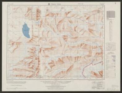
Trigu Tsho
1 : 2500000 United States. Army Map Service. Army Map Service
Yamdrog Tsho
1 : 2500000 United States. Army Map Service. Army Map Service
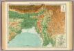
Assam, Bhutan & Tibet, No 78M. Towang
Maps from other India Office departments Survey of India
Karte von Assam und seinen Nachbar-Ländern
1 : 1000000 gest. von W. Brose u. W. Jaeck Gotha : Perthes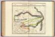
Assam et Boutan. Asie 84.
1 : 1641836 Vandermaelen, Philippe, 1795-1869
The Province of Bengal and Assam
India Office reference collection of maps Survey of India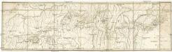
Carte de la route de Tchhing Tou Fou a H'lassa
Lhasa (Čína) Berthe
India - north-eastern section.
1 : 4000000 John Bartholomew & Co.
Northern India Including The Presidency of Calcutta.
1 : 9000000 Tallis, J. & F.
N. Hindostan.
1 : 4400000 Thomson, John
137-138. North India, Nepal, East Pakistan. The World Atlas.
1 : 5000000 USSR (Union of Soviet Socialist Republics).
Inde N.-E. et Tibet.
1 : 5000000 Vivien St Martin, L.
Undecima Asie Tabula [Karte], in: [Clavdii Ptholomei Cosmographi ...], S. 332.
1 Karte aus Atlas Nicolaus Germanus [und Ptolemaeus, Claudius]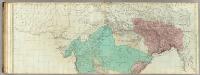
The East Indies, with the roads (northern section).
1 : 2600000 Jefferys, Thomas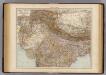
India North.
1 : 6000000 Andree, Richard; Times (London, England)
120-121. China, West. The World Atlas.
1 : 5000000 USSR (Union of Soviet Socialist Republics).
Das Himálaja Gebirg in Bissahir, Gherwal & Kemaun, von Südrande des Plateaus von Mittel-Tibet bis zum Tieflande von Hindostan
1 : 900000 Himálaj Grimm, J. L. Etzel, Franz August von C. Ritter und F.A. O'etzel
Das Himalaja Gebirg in Bissahir, Gherwal & Kemaun, von Südrande des Plateaus von Mittel-Tibet bis zum Tieflande von Hindostan
1 : 900000 Himálaj Grimm, J. L. Etzel, Franz August von C. Ritter und F.A. O'etzel
Siam, Burma & Anam.
1 : 6969600 Stanford, Edward
Hinterindien
1 : 4000000 dem Sir Francis Hamilton [...] gewidmet vom Verfasser [H. Berghaus] gest. von W. Brose Gotha : Perthes
HINTERINDIEN
1 : 4000000 Kambodža Berghaus, Heinrich Karl Wilhelm Brose, W. Justus Perthes
Entwurf des Birmanschen Reichs
Kambodža Dalrymple
Tabula Asiae XI. [Karte], in: Geographia universalis vetus et nova complectens Claudii Ptolemaei Alexandrini enarrationis libros VIII, S. 296.
1 Karte aus Atlas Münster, Sebastian [und Ptolemaeus, Claudius]
Hinter Indien.
1 : 9400000 Radefeld, Carl Christian Franz, 1788-1874
Inner-Asien & Indien
1 : 7500000 Bangladéš Petermann, August Lüddecke, Richard Justus Perthes
[Indien & Inner-Asien, Nördliches Blatt]
Handatlas über alle Theile der Erde und über das Weltgebäude Stieler, Adolf Justus Perthes
Birman Empire & Countries South East of the Ganges.
1 : 7650000 Teesdale, Henry
Imperii magni Mogolis sive Indici Padschach, juxta recentißimas navigationes accurata delineatio geographica
Indie Seutter, Matthäus Seutter, Albrecht Carl sumtibus Matth. Seutteri