Maps of China

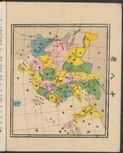
地理志略:大清國圖
地理志略 1903年,Alice S. Parker 此为用厦门闽南方言表述、罗马拼音书写的世界地理介绍性著作,介绍了清朝地理和世界六大洲地理概况。内有《大清國》图和《十八省》图,分别为全清和内地省级行政区划图。 2图,彩色,厦门方言罗马拼音,19.8 x 22.8 cm Harvard-Yenching | Rare Book | TA 2380 68.1,Hollis Number:008161903
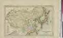
天下九邊萬國人跡路程全圖
天下九邊萬國人跡路程全圖 康熙二年(1663年),姑苏王君甫 此图按内容上属于世界地图,主体部分刻绘了明朝两京十三省府、州、县及边镇卫所等。图东北方绘制了大东洋和美洲(加拿太国和古巴岛等),东南方绘制了日本国、毛人国、女人国、川心国等,该图对南方的绘制方位变形很大,福建已到图下方,该方位的海面有琉球国、三首国、三身国、金齿国等;图西南方向则有大食、槟榔、吕蒙等以及黄河源头昆仑山附近的葫芦形湖泊“星宿海”;图西北方则为大西洋、非洲和欧洲,标注了泥禄河、地中海、佛沙国等;北部则标注了鞑靼等地。这反映明清之际人们对世界的认识。全图由八块刻板拼印而成,有较明显的拼接痕迹。 图上方为题记,左侧罗列外国名称及简介,右侧罗列边疆重要卫所和关隘,下方是题为《天下京省九边外国府州县路程图》的各省文字解说,内容包括两京十三省的地理方位、历史沿革、户口数、米麦、绢丝棉麻、盐引数等统计数据,同时附有两京十三省下辖府县数及到其他省份的里程。 图上府用正方形,着红色;县用椭圆形,着黄色;州及西南土州、土府、长官司等用长方形,着深褐色;卫所用菱形,着浅褐色。大洋、河流、湖泊等水域绘有波纹。 本图为民间私刻,内容和形制上与明万历二十一年梁辀镌刻的《乾坤萬國全圖古今人物事蹟》、明崇祯十七年曹君义刻印的《天下九邊分野人跡路程全圖》、明末季名台刻印的《九州分野輿圖古今人物事跡》等图相似,应有较强的传承关系。在本图成图之后,日本帝幾書坊梅村彌白曾翻刻了王君甫的这张图,将图题和图下解说中的“天下”改为“大明”,称为《大明九邊萬國人跡路程全圖》,除此以外,内容完全一致,只是图上府、州、县、卫所等未着色而已,可以说是本图的复印件。 1图,刻本,彩色,中文,125 x 122.5 cm Harvard-Yenching | Rare Book | T 3080 4643,Hollis Number:008690193 姑蘇:王君甫
新東亞資源開發解說地圖
1 : 8000000 新東亞資源開發解說地圖 昭和十四年[1939]1月1日,相马基 编辑,东京:东京日日新聞社 调查编纂及发行。 主体部分以中国省级行政区为主,兼及周边日本、朝鲜、尼泊尔、不丹等地,用形象图形,标注东亚各地主要的农业、牧业、矿业资源。地图背面为中国各省简介。 1图,彩色,日文,图幅54.6 x 79.2 cm,比例尺1:8,000,000,经纬度E 68°- E148°;N 18°-53°)。 Harvard-Yenching | Manchuguo J-0825;Hollis Number:014623812 相马基 东京日日新聞社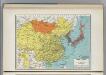
China and Japan.
1 : 15474000 Hammond, C.S.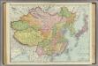
East Asia.
1 : 8997000 Rand McNally and Company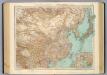
97-98. Dominio Cinese, Impero Giapponese.
1 : 10000000 Touring club italiano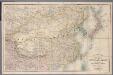
[Kaart], uit: Stanford's map of the empires of China and Japan : with the adjacent parts of the Russian Empire, India, Burma &c
1 : 6000000 titelvariant: Stanford's map of China & Japan; Annotatie: Omslagtitel: Stanford's map of China & Japan London : Stanford
Chinese Empire and Japan.
1 : 19500000 Schonberg & Co.
中華民國現勢圖
1 : 10000000 中華民國現勢圖 昭和十二年[1937]7月20日,鐵道省運輸局编纂,东京:东京朝日新聞社 增补发行 为中国省级行政区划图,由于此图系日本绘制,东北伪满洲国被绘在国界线外。图上绘制了省级争取分界线、铁路、公路和航空线路等。按照20世纪三十年代的制图水准看,此图的绘制精度较差,不论是省界还是海岸线都存在较大偏差。 插图1幅:《北平附近圖》,主要绘制冀东地区傀儡政权和卢沟桥附近地形图。另有2表:《中國國民黨及國民政府組織(附)》和《中國の陸軍及び空軍》,内容为民国党政机构架构和军力数据。 1图,彩色,日文,图幅53.8 x 71.6 cm,比例尺1:10,000,000,经纬度为E75°-140°; N18°-55°。 Harvard-YenchingManchuguo J-0817;Hollis Number:014622127 鐵道省運輸局 东京朝日新聞社
韓國輿地圖:中國
Manuscript. Imprint date from postscript. 金鴻圭
天下輿地圖:中國圖
天下輿地圖 明清时期 该图集为李氏朝鲜时期舆图,前有《天下圖》和《中國圖》各一幅,后为朝鲜八道图及日本图。封面题有“玄黓執徐腊下瀚”,可能是壬辰年十二月下旬,但具体年份待定。内容与形态基本与上图相同(005833853),《天下圖》反映中国传统天下观,中国居中,周围岛国取自《山海经》,《中國圖》绘制明朝两京十三省。 1图,彩绘,中文,图幅27.8 x 34.3 cm。 Harvard-Yenching | Rare Book | TK 3490.7 1174;Hollis Number:009140732
108-109. China, Mongolia, Korea. The World Atlas.
1 : 10000000 USSR (Union of Soviet Socialist Republics).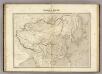
Chine et Japon.
1 : 10250000 Montemont, A.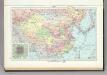
107. China, Political. The World Atlas.
1 : 15000000 USSR (Union of Soviet Socialist Republics).
Das Chinesische Reich und das Kaiserthum Japan
1 : 10666000 entworfen und gezeichnet von C. F. Weiland Weimar : Verlag des Geograph. Instituts
Empire Chinois et Japon.
1 : 14000000 Levasseur, E.
Empire Chinois, Japon.
1 : 13600000 Picquet, C.
Chinese Empire And Japan.
1 : 15840000 Burr, David H., 1803-1875
Das Chinesische Reich und das Kaiserthum Japan
1 : 10780000 Japonsko Humboldt, Alexander von im Verlage des Geograph. Institut
China [Karte], in: Gerardi Mercatoris Atlas, sive, Cosmographicae meditationes de fabrica mundi et fabricati figura, S. 532.
1 Karte aus Atlas Mercator, Gerhard Montanus, Petrus
L'Empire Chinois et du Japon.
1 : 23600000 Malte-Brun, Conrad, 1775-1826
Chinesisches Reich
1 : 16800000 Čína Mollo, Tranquillo bey Tranquillo Mollo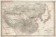
Karte VON CHINA UND JAPAN
1 : 6850000 Japonsko Berghaus, Heinrich Karl Wilhelm Anville, Jean-Baptiste Bourguinon d' Justus Perthes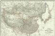
Karte von China und Japan
Japonsko Anville, Jean-Baptiste Bourguinon d' H.B.
Chinese Empire And Japan.
1 : 19300000 Greenleaf, Jeremiah
Chinese Empire And Japan.
1 : 19300000 Greenleaf, Jeremiah
The Chinese Empire compiled from native and foreign authorities
1 : 9700000 The Chinese Empire Compiled from Native and Foreign Authorities 1882年,S. Wells Williams卫三畏 (1812-1884)绘制,Jacob Wells修订,G. Stern刻版,New York: Charles Scribner's Sons出版。 该图详细刻画了清末中国疆域、行政区划及边疆地区。卫三畏曾在1847年左右曾出版了一幅题为Map of the Chinese empire, compiled from native & foreign authorities的彩色中国地图,现藏于国会图书馆,1953年又出版了一幅题为Map of the Chinese Empire : compiled from native & foreign authorities的黑白中国地图(仅部分着黄色),而1882年的这版中国地图,是在前两版的基础上,根据新调查的数据进行修订而成。卫三畏是清末最为杰出的汉学家,对中国有着持续深入的研究,这幅地图可以代表19世纪末西方对中国疆域和政区认识的最高水平,尤其是对内陆边疆和海疆的认识。 附插图2幅:Map of the City of Canton & Adjacent Islands,描绘珠三角地形与广州城市格局;Harbor & Island of Amoy,描绘厦门岛及周边海湾。 Map of the city of Canton & adjacent islands, Harbor & island of Amoy 1图,黑白印刷,英文,图幅49 x 54 cm,比例尺约为1:9,700,000,经纬度约为E65°-140°; N18°-55°。 Harvard-Yenching | Offsite Storage (HD)|MLC-C|HY53A6,Hollis Number:008375431 S. Wells Williams New York: Charles Scribner's Sons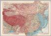
Mongolia and China. Pergamon World Atlas.
1 : 10000000 Polish Army Topography Service