Maps of Baden-Württemberg

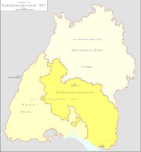
Länder in Südwestdeutschland 1947
Land Baden, Württemberg-Hohenzollern Kunz, Andreas ; Treiling, Thomas ; Moeschl, Joachim
Das Kœnigreich Würtemberg nebst dem Grosherzogthum Baaden, den Fürstenthümern Hohenzollern und Layen
1 Karte : Kupferdruck ; 59 x 53 cm Pflummern in A. G. Schneider u: Weigels kön: priv: Kunst u: Landkartenhandlung
Charte von dem Königreiche Wirtemberg und dem Grossherzogthume Baaden

Grossherzogthum Baden
1 : 824000 Bádensko (Německo) Martin Gleditsch
[Charte vom Königreich Würtemberg, und dem Grossherzogthum Baden]
Neuester Schul-Atlas Walch, Johann im Verlag bei Joh. Walch
Charte von dem Königreiche Wirtemberg, und dem Grosherzogthume Baaden
1 : 620000 Bádensko (Německo) Streit, Friedrich Wilhelm im Verlage des Geogr. Instituts
Nördliche Fortsetzung des Rhein von Oppenheim bis Köln
Hand-Atlas über alle Theile der Erde nach dem neuesten Zustande und über das Weltgebäude Stieler, Adolf bei Justus Perthes
Nördliche Fortsetzung des Rhein von Oppenheim bis Köln
Hand-Atlas über alle Theile der Erde nach dem neuesten Zustande und über das Weltgebäude Stieler, Adolf bei Justus Perthes
Cours du Danube feuille I contenant la Suabe ou est exactement marquée la succession de Charles VI
1 Karte : Kupferdruck ; 47 x 55 cm Le Rouge chez le Rouge rue des Augustins vis a vis le Panier Fleuri
Charte über das Grossherzogthum Baden
1 Karte : Kupferdruck ; 61 x 38 cm Tulla; Müller; Hutter verlegt bei C. F. Müller Hofbuchdrucker
Wurtemberg, Baden.
1 : 450000 Weiland, C. F. (Carl Ferdinand), d. 1847
[Der Rhein vom Boden-See bis Cöln zugleich als Special-Karte von Würtemberg und Baden]
Stieler's Hand-Atlas Stieler, Adolf bei Justus Perthes
Charte von dem Königreiche Wirtemberg und dem gros Herzogthume Baaden
1 : 800000 Bádensko (Německo)
CHARTE von dem KÖNIGREICHE WIRTEMBERG und dem GROSHERZOGTHUME BAADEN
1 : 800000 Bádensko (Německo)
Hessen-Nassau, Groszherzogtum Hessen und Furstentum Waldeck
1 : 500000 Scobel, Albert
Circulus Sueviæ
1 Karte : Kupferdruck ; 47 x 54 cm Homann Johann Baptist Homann
Geognostische Karte von Württemberg, Baden und Hohenzollern
1 : 700000 Bach, Carl Philipp Heinrich Verlag der G. Ebner'schen Kunsthandlung
Circolo di Svevia diviso ne suoi stati
1 Karte : Kupferdruck ; 31 x 40 cm Zatta; Zuliani; Pitteri presso Antonio Zatta
Charte des Königreichs Würtemberg und des Grossherzogthums Baadens nebst den angränzenden Ländern
1 : 698000 Bádensko (Německo) Tranquillo Mollo
Sveviae utriusque cum Germanicæ tum Rheticæ celebratissimis vrbibus
1 Karte : Kupferdruck ; 20 x 22 cm, Bildgrösse 21 x 29 cm Seltzlin; Quad; Bussemacher excudit Johan Buchsemecher
Straßen im Großherzogtum Baden 1848
Baden Straßennetz Kunz, Andreas ; Treiling, Thomas
Circulus Suevicus
1 Karte : Kupferdruck ; 48 x 56 cm Lotter Tobias Konrad Lotter
Palatinat du Rhein, Alsace, et Partie de Souabe de Franconie &c.
1 : 870000 Mollova mapová sbírka Sanson, Nicolas Cordier, Robert Sanson, Nicolas
S.R.I. Sueviae Circulus atq. Ducatus una cum Insertis et Adjacentibus Regionibus, accuratissime in earundem particulares Provincias divisum
1 : 620000 Mollova mapová sbírka Visscher, Nicolaes Schenk, Peter II
Neueste Karte von Württemberg, Baden, Hohenzollern, die Rheinpfalz nebst den deutschen Reichslanden Elsass und Lothringen : zum Hand- und Comptoir-Gebrauch bearbeitet und namentlich mit Rücksicht auf Eisenbahnen als Reise- und Verkehrskarte angelegt
Baur, Carl Friedrich Wittwer
Circulus sive Liga Sueviae Vulgo Schwabische Kraiß. [Karte], in: Theatrum orbis terrarum, S. 179.
1 Karte aus Atlas Ortelius, Abraham
S. R. I. Circulus Sueviae Continens Ducatum Wirtenbergensem Aliosq[ue] Status Et Provincias Eidem Circulo Insertas
1 : 620000 Homann, Johann Baptist
Gross Herzogthum Baden
Grosser Hand-Atlas über alle Theile der Erde in 170 Karten Meyer, J. Verlag des Bibliographischen Instituts