Maps of Europe

Europa 1881
Europa Kunz, Andreas ; Röss, Wolf ; Moeschl, Joachim Robert
Europa 1878
Europa Kunz, Andreas ; Röss, Wolf ; Moeschl, Joachim Robert
Europa 1804
Europa Kunz, Andreas ; Moeschl, Joachim Robert
Europa 1885
Europa Kunz, Andreas ; Röss, Wolf ; Moeschl, Joachim Robert
Europa 2008
Europa Kunz, Andreas ; Moeschl, Joachim Robert
Europa 1911
Europa Kunz, Andreas ; Röss, Wolf ; Moeschl, Joachim Robert
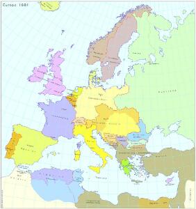
Europa 1861
Europa Kunz, Andreas ; Röss, Wolf ; Moeschl, Joachim Robert
Europa 1993
Europa Kunz, Andreas ; Moeschl, Joachim Robert
[Botanisch-Geographisch-Statistische Karte von Europa]
Zweiter Band, enthaltend in vier Abtheilungen die Vertheilung der Organismen: 5. Pflanzen-Geographie, 6. Thier-Geographie, 7. Anthropographie, 8. Ethnographie Humboldt, Alexander von Verlag von Justus Perthes
Europe : laid down from the observations of the Royal Academy of Sciences & compared with the maps of Sanson, Nolin, Du Fer, De l'Isle, Moll & other modern geographers ... / [John Bowles] ; engrav'd by Emanuel Bowen
1 : 4500000 Annotatie: Met tabel van Europese lengtematen; Met informatie over de verschillende Europese staten Bowles, John; Bowen, Emanuel London : printed for John Bowles
EVROPA
recens descripta | à | Guilielmo Blaeuw. [Amsterdam : Joan Blaeu]
Europa 1867
Europa Kunz, Andreas ; Röss, Wolf ; Moeschl, Joachim Robert
Europa
Geographischer Atlas über alle Theile der Erde Ziegler, Jakob Melchior Verlag von Dietrich Reimer
L'Europe, suivant les nouvelles observations de Messrs. de l'Academie Royale des Sciences, etc.
1 : 5100000 augmentées de nouveau Leyde : chez Pierre van der Aa
Carte Geologique De L'Europe.
1 : 3800000 Dumont, Andre
Europa Exactissime Descripta [Karte], in: Gerardi Mercatoris et I. Hondii Newer Atlas, oder, Grosses Weltbuch, Bd. 1, S. 30.
1 Karte aus Atlas Mercator, Gerhard und Hondius, Jodocus Jansson, Jan
Europa 1923
Europa Kunz, Andreas ; Moeschl, Joachim Robert
Europa 1975
Europa Kunz, Andreas ; Moeschl, Joachim Robert
Europa 1949
Europa Kunz, Andreas ; Moeschl, Joachim Robert
Europa 1820
Europa Kunz, Andreas ; Röss, Wolf ; Moeschl, Joachim Robert
Der europäische Raum
1 : 6000000 Afrika severní Richard Schwarz, Landkarten-Handlung und Geogr. Verlag
Europa 1789
Europa Kunz, Andreas ; Moeschl, Joachim Robert
Der europäische Kontinent
1 : 7500000 Evropa Verlagsanstalt List und von Bressensdorf
Europa Übersicht der politischen Verhältnisse und Hauptverkehrswege
1 : 20000000 Europa Verkehrsnetz
Europa 1812
Europa Kunz, Andreas ; Moeschl, Joachim Robert
Europe.
1 : 21542400 Lucas, Fielding Jr.
Carte demonstrative des déterminations télégraphiques de différences de longitudes
1 : 10000000 Institut topographique militaire
Europa Exactissime Descripta [Karte], in: Novus atlas absolutissimus, Bd. 1, S. 25.
1 Karte aus Atlas Janssonius Offizin
Europa
[Allgemeiner Atlas über alle Theile der Erde in 29 Blättern] Ziegler, Jakob Melchior Top. Anstalt v. J. Wurster u. Comp.