Maps of Europe

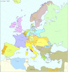
Europa 1867
Europa Kunz, Andreas ; Röss, Wolf ; Moeschl, Joachim Robert
Europa 1861
Europa Kunz, Andreas ; Röss, Wolf ; Moeschl, Joachim Robert
Europa 1993
Europa Kunz, Andreas ; Moeschl, Joachim Robert
Europa 2008
Europa Kunz, Andreas ; Moeschl, Joachim Robert
[Botanisch-Geographisch-Statistische Karte von Europa]
Zweiter Band, enthaltend in vier Abtheilungen die Vertheilung der Organismen: 5. Pflanzen-Geographie, 6. Thier-Geographie, 7. Anthropographie, 8. Ethnographie Humboldt, Alexander von Verlag von Justus Perthes
Europa 1885
Europa Kunz, Andreas ; Röss, Wolf ; Moeschl, Joachim Robert
Europa 1911
Europa Kunz, Andreas ; Röss, Wolf ; Moeschl, Joachim Robert
Europa 1804
Europa Kunz, Andreas ; Moeschl, Joachim Robert
Europa 1789
Europa Kunz, Andreas ; Moeschl, Joachim Robert
Europa 1878
Europa Kunz, Andreas ; Röss, Wolf ; Moeschl, Joachim Robert
Europa 1812
Europa Kunz, Andreas ; Moeschl, Joachim Robert
Europa 1881
Europa Kunz, Andreas ; Röss, Wolf ; Moeschl, Joachim Robert
Europa 1820
Europa Kunz, Andreas ; Röss, Wolf ; Moeschl, Joachim Robert
Europa 1975
Europa Kunz, Andreas ; Moeschl, Joachim Robert
Europa 1812 - Das napoleonische Staatensystem
Europa Kunz, Andreas ; Moeschl, Joachim Robert
Europa 1949
Europa Kunz, Andreas ; Moeschl, Joachim Robert
Europa 1795
Europa Kunz, Andreas ; Moeschl, Joachim Robert
EVROPA
recens descripta | à | Guilielmo Blaeuw. [Amsterdam : Joan Blaeu]
Europa 1923
Europa Kunz, Andreas ; Moeschl, Joachim Robert
Europa 1668
Europa Kunz, Andreas ; Moeschl, Joachim Robert
Europa 1714
Europa Kunz, Andreas ; Moeschl, Joachim Robert
Europa 1908
Europa Kunz, Andreas ; Röss, Wolf ; Moeschl, Joachim Robert
Europa 1914
Europa Kunz, Andreas ; Moeschl, Joachim Robert
L'Europe, suivant les nouvelles observations de Messrs. de l'Academie Royale des Sciences, etc.
1 : 5100000 augmentées de nouveau Leyde : chez Pierre van der Aa
Europa 1718
Europa Kunz, Andreas ; Moeschl, Joachim Robert
Carte Geologique De L'Europe.
1 : 3800000 Dumont, Andre
Europa 1748
Europa Kunz, Andreas ; Moeschl, Joachim Robert
Europe : laid down from the observations of the Royal Academy of Sciences & compared with the maps of Sanson, Nolin, Du Fer, De l'Isle, Moll & other modern geographers ... / [John Bowles] ; engrav'd by Emanuel Bowen
1 : 4500000 Annotatie: Met tabel van Europese lengtematen; Met informatie over de verschillende Europese staten Bowles, John; Bowen, Emanuel London : printed for John Bowles
Europa Exactissime Descripta [Karte], in: Gerardi Mercatoris et I. Hondii Newer Atlas, oder, Grosses Weltbuch, Bd. 1, S. 30.
1 Karte aus Atlas Mercator, Gerhard und Hondius, Jodocus Jansson, Jan